
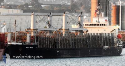
KEN BOS
Cargo
Current Trip
IDJKT
| Time Travelled | 11 days |
|---|---|
| Remaining Time | --- |
| Distance Travelled | 3397.32 nm |
| Remaining Distance | --- |
| AVG Speed | 11.8 Knots |
| MAX Speed | 14.1 Knots |
| AVG Wind | 10.6 knots |
| MAX Wind | 24.8 knots |
| MIN Temp | 23.3°C / 73.94°F |
| MAX Temp | 29.8°C / 85.64°F |
| Draught | 8.1 m |
| Position Received | 1 d ago |
Current Position
| Longitude | 133.65159° |
|---|---|
| Latitude | 20.00766° |
| Status | Under way using engine |
| Speed | 12.5 Knots |
| Course | 19.5° |
| Area | Philippine Sea |
| Station | T-AIS |
| Position Received | 1 d ago |
Info
Information
The current position of KEN BOS is in Philippine Sea with coordinates 20.00766° / 133.65159° as reported on 2024-06-03 07:08 by AIS to our vessel tracker app. The vessel's current speed is 12.5 Knots
The vessel KEN BOS (IMO: 9846146, MMSI: 352003248) is a Cargo It's sailing under the flag of [PA] Panama.
In this page you can find informations about the vessels current position, last detected port calls, and current voyage information. If the vessels is not in coverage by AIS you will find the latest position.
The current position of KEN BOS is detected by our AIS receivers and we are not responsible for the reliability of the data. The last position was recorded while the vessel was in Coverage by the Ais receivers of our vessel tracking app.
The current draught of KEN BOS as reported by AIS is 8.1 meters
Weather
| Temperature | 24.6°C / 76.28°F |
|---|---|
| Wind Speed | 16 knots |
| Direction | 13° NNE |
| Pressure | 1011.2 hPa |
| Humidity | 67.7 % |
| Cloud Coverage | 4 % |
Featured Company
Last Port Calls
| Port | Arrival | Departure | Time In Port |
|---|---|---|---|
| 2024-05-23 01:15 | 2024-05-24 03:54 | 1 d | |
| 2024-05-15 20:27 | 2024-05-16 15:39 | 19 h | |
| 2024-05-12 04:24 | 2024-05-13 06:40 | 1 d | |
| 2024-05-08 01:42 | 2024-05-09 09:32 | 1 d | |
| 2024-04-28 06:12 | 2024-05-01 00:00 | 2 d | |
| 2024-04-24 09:57 | 2024-04-27 15:48 | 3 d | |
| 2024-04-13 04:42 | 2024-04-20 15:32 | 7 d |
Last Trips
| Origin | Departure | Destination | Arrival | Distance | |
|---|---|---|---|---|---|
| 2024-05-16 22:39 | 2024-05-23 09:15 | 1347.52 nm | |||
| 2024-05-13 14:40 | 2024-05-16 03:27 | 791.03 nm | |||
| 2024-05-09 16:32 | 2024-05-12 12:24 | 821.89 nm | |||
| 2024-05-01 09:00 | 2024-05-08 08:42 | 2075.38 nm | |||
| 2024-04-28 00:48 | 2024-04-28 15:12 | 184.98 nm | |||
| 2024-04-20 23:32 | 2024-04-24 18:57 | 577.17 nm | |||
| 2024-03-23 11:16 | 2024-04-13 12:42 | 5499.85 nm |
Events
| Time | Event | Details | Position / Dest | Info |
|---|---|---|---|---|
| 2024-06-03 07:10 | Status Changed | Default Under way using engine |
20.01333 / 133.65334
IDJKT
|
Speed: 12.5 kn Course: 19.5° |
| 2024-06-03 07:08 | OUT of Coverage |
20.00766 / 133.65159
Philippine Sea
|
Speed: 12.5 kn Course: 19.5° |
|
| 2024-06-03 06:37 | Change Sea Area | Japanese part of the Philippine Sea Malaysian part of the South China Sea |
19.90667 / 133.61306
Philippine Sea
|
Speed: 12.2 kn Course: 17.9° |
| 2024-06-03 06:35 | Status Changed | Under way using engine Default |
19.90064 / 133.61101
IDJKT
|
Speed: 12.3 kn Course: 20° |
| 2024-06-03 06:22 | IN Coverage |
19.90667 / 133.61306
Philippine Sea
|
Speed: 12.2 kn Course: 17.9° |