
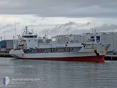
GREEN EGERSUND
Reefer
Current Trip
| Time Travelled | 8 days |
|---|---|
| Remaining Time | --- |
| Distance Travelled | 526.45 nm |
| Remaining Distance | 2.33 nm |
| AVG Speed | 11.4 Knots |
| MAX Speed | 14 Knots |
| AVG Wind | 19.9 knots |
| MAX Wind | 24.8 knots |
| MIN Temp | 15.8°C / 60.44°F |
| MAX Temp | 20.2°C / 68.36°F |
| Draught | 6.1 m |
| Position Received | 8 d ago |
Current Position
| Longitude | -15.27235° |
|---|---|
| Latitude | 27.54957° |
| Status | Under way using engine |
| Speed | 12.8 Knots |
| Course | 199° |
| Area | North Atlantic Ocean |
| Station | T-AIS |
| Position Received | 8 d ago |
Info
Information
The current position of GREEN EGERSUND is in North Atlantic Ocean with coordinates 27.54957° / -15.27235° as reported on 2024-05-11 01:54 by AIS to our vessel tracker app. The vessel's current speed is 12.8 Knots and is heading at the port of NOUADHIBOU. The estimated time of arrival as calculated by MyShipTracking vessel tracking app is 2024-05-12 16:00 LT
The vessel GREEN EGERSUND (IMO: 8804567, MMSI: 311040500) is a Reefer that was built in 1990 ( 34 years old ). It's sailing under the flag of [BS] Bahamas.
In this page you can find informations about the vessels current position, last detected port calls, and current voyage information. If the vessels is not in coverage by AIS you will find the latest position.
The current position of GREEN EGERSUND is detected by our AIS receivers and we are not responsible for the reliability of the data. The last position was recorded while the vessel was in Coverage by the Ais receivers of our vessel tracking app.
The current draught of GREEN EGERSUND as reported by AIS is 6.1 meters
Weather
| Temperature | 18°C / 64.4°F |
|---|---|
| Wind Speed | 16 knots |
| Direction | 4° N |
| Pressure | 1013 hPa |
| Humidity | 86.7 % |
| Cloud Coverage | 3 % |
Featured Company
Last Port Calls
| Port | Arrival | Departure | Time In Port |
|---|---|---|---|
| 2024-05-10 09:23 | 2024-05-10 23:39 | 14 h | |
| 2024-04-25 09:52 | 2024-05-02 16:57 | 7 d | |
| 2024-04-11 15:25 | 2024-04-12 14:17 | 22 h | |
| 2024-04-03 15:35 | 2024-04-11 13:00 | 7 d | |
| 2024-03-13 08:58 | 2024-03-14 07:56 | 22 h |
Most Visited Ports (Last year)
| Port | Arrivals | |
|---|---|---|
| 8 | ||
| 2 | ||
| 2 | ||
| 2 | ||
| 1 | ||
| 1 |
Last Trips
| Origin | Departure | Destination | Arrival | Distance | |
|---|---|---|---|---|---|
| 2024-05-02 16:57 | 2024-05-10 09:23 | 41.92 nm | |||
| 2024-04-12 14:17 | 2024-04-25 09:52 | 3418.20 nm | |||
| 2024-04-11 13:00 | 2024-04-11 15:25 | 29.60 nm | |||
| 2024-03-14 07:56 | 2024-04-03 15:35 | 850.82 nm | |||
| 2024-02-23 11:00 | 2024-03-13 08:58 | 2950.07 nm |
Events
| Time | Event | Details | Position / Dest | Info |
|---|---|---|---|---|
| 2024-05-18 04:06 | STOP Moving | 1.89 nm, East of NOUADHIBOU |
20.89833 / -17.00833
MRNDB
|
Speed: Course: -1° |
| 2024-05-18 02:22 | START Moving | 2.52 nm, South East of NOUADHIBOU |
20.88231 / -17.00239
MRNDB
|
Speed: 3.5 kn Course: 144° |
| 2024-05-17 16:24 | STOP Moving | 2.66 nm, South East of NOUADHIBOU |
20.88500 / -16.99833
MRNDB
|
Speed: Course: -1° |
| 2024-05-17 16:09 | START Moving | 2.36 nm, South East of NOUADHIBOU |
20.88667 / -17.00333
MRNDB
|
Speed: 4 kn Course: -1° |
| 2024-05-13 20:04 | STOP Moving | 2.11 nm, South East of NOUADHIBOU |
20.88667 / -17.00833
MRNDB
|
Speed: Course: -1° |
| 2024-05-13 18:34 | START Moving | 2.08 nm, East of NOUADHIBOU |
20.89049 / -17.00710
MRNDB
|
Speed: 4.8 kn Course: 144° |
| 2024-05-12 16:58 | STOP Moving | 1.81 nm, East of NOUADHIBOU |
20.89167 / -17.01167
MRNDB
|
Speed: Course: -1° |
| 2024-05-11 02:02 | Status Changed | Default Under way using engine |
27.52218 / -15.28427
MRNDB
|
Speed: 12.8 kn Course: 199° |
| 2024-05-11 01:54 | OUT of Coverage |
27.54957 / -15.27235
North Atlantic Ocean
MRNDB
|
Speed: 12.8 kn Course: 199° |
|
| 2024-05-10 22:39 | PORT DEPARTURE |
|
28.11528 / -15.40633
MRNDB
|
Speed: 8.2 kn Course: 113° |