
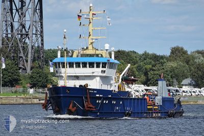
FORTUNA CRANE
Tug/Supply Vessel
Current Trip
| Time Travelled | 2 days |
|---|---|
| Remaining Time | 17 h, 28 mins |
| Distance Travelled | 205.99 nm |
| Remaining Distance | 73.45 nm |
| AVG Speed | 4.8 Knots |
| MAX Speed | 13.9 Knots |
| AVG Wind | 12.4 knots |
| MAX Wind | 18.6 knots |
| MIN Temp | 10.3°C / 50.54°F |
| MAX Temp | 15.3°C / 59.54°F |
| Draught | 3 m |
| Position Received | Now |
Current Position
| Longitude | 8.05208° |
|---|---|
| Latitude | 54.97355° |
| Status | Under way using engine |
| Speed | 4.4 Knots |
| Course | 181° |
| Area | North Sea |
| Station | T-AIS |
| Position Received | Now |
Info
Information
The current position of FORTUNA CRANE is in North Sea with coordinates 54.97355° / 8.05208° as reported on 2024-05-05 13:30 by AIS to our vessel tracker app. The vessel's current speed is 4.4 Knots and is heading at the port of CUXHAVEN. The estimated time of arrival as calculated by MyShipTracking vessel tracking app is 2024-05-06 06:59 LT
The vessel FORTUNA CRANE (IMO: 7403158, MMSI: 219031237) is a Tug/Supply Vessel that was built in 1975 ( 49 years old ). It's sailing under the flag of [DK] Denmark.
In this page you can find informations about the vessels current position, last detected port calls, and current voyage information. If the vessels is not in coverage by AIS you will find the latest position.
The current position of FORTUNA CRANE is detected by our AIS receivers and we are not responsible for the reliability of the data. The last position was recorded while the vessel was in Coverage by the Ais receivers of our vessel tracking app.
The current draught of FORTUNA CRANE as reported by AIS is 3 meters
Weather
| Temperature | 11°C / 51.8°F |
|---|---|
| Wind Speed | 13 knots |
| Direction | 19° NNE |
| Pressure | 1003.7 hPa |
| Humidity | 93.9 % |
| Cloud Coverage | 100 % |
Featured Company
Last Port Calls
| Port | Arrival | Departure | Time In Port |
|---|---|---|---|
| 2024-04-30 04:51 | 2024-05-03 12:02 | 3 d | |
| 2024-04-28 06:05 | 2024-04-29 13:36 | 1 d | |
| 2024-04-23 17:09 | 2024-04-25 15:02 | 1 d | |
| 2024-04-21 12:25 | 2024-04-22 04:50 | 16 h | |
| 2024-04-10 21:30 | 2024-04-20 22:43 | 10 d | |
| 2024-04-09 10:52 | 2024-04-09 13:50 | 2 h | |
| 2024-04-04 06:03 | 2024-04-04 06:05 | 2 m | |
| 2024-03-31 03:52 | 2024-04-03 16:11 | 3 d | |
| 2024-03-21 10:48 | 2024-03-25 17:17 | 4 d | |
| 2024-03-17 09:21 | 2024-03-18 20:21 | 1 d |
Last Trips
| Origin | Departure | Destination | Arrival | Distance | |
|---|---|---|---|---|---|
| 2024-04-29 15:36 | 2024-04-30 06:51 | 106.82 nm | |||
| 2024-04-25 17:02 | 2024-04-28 08:05 | 57.03 nm | |||
| 2024-04-22 06:50 | 2024-04-23 19:09 | 42.62 nm | |||
| 2024-04-21 00:43 | 2024-04-21 14:25 | 134.59 nm | |||
| 2024-04-09 15:50 | 2024-04-10 23:30 | 213.12 nm | |||
| 2024-04-04 08:05 | 2024-04-09 12:52 | 288.66 nm | |||
| 2024-04-03 18:11 | 2024-04-04 08:03 | 69.27 nm | |||
| 2024-03-25 18:17 | 2024-03-31 05:52 | 332.82 nm | |||
| 2024-03-18 21:21 | 2024-03-21 11:48 | 343.97 nm | |||
| 2024-03-16 23:19 | 2024-03-17 10:21 | 108.81 nm |
Events
| Time | Event | Details | Position / Dest | Info |
|---|---|---|---|---|
| 2024-05-05 06:14 | IN Coverage |
54.87660 / 7.68890
North Sea
DE CUX
|
Speed: 7.6 kn Course: 89.2° |
|
| 2024-05-05 04:33 | OUT of Coverage |
54.83536 / 7.49599
North Sea
DE CUX
|
Speed: 3.8 kn Course: 69.7° |
|
| 2024-05-05 03:36 | Destination Changed | DE CUX OWF BUTENDIEK |
54.81264 / 7.39221
DE CUX
|
Speed: 3.8 kn Course: 59° |
| 2024-05-05 03:36 | ETA Changed | 2024/05/06 12:00 2024/05/03 19:00 |
54.81264 / 7.39221
DE CUX
|
Speed: 3.8 kn Course: 59° |
| 2024-05-05 02:22 | IN Coverage |
54.78022 / 7.29991
North Sea
|
Speed: 1 kn Course: 260.6° |
|
| 2024-05-05 00:22 | OUT of Coverage |
54.82815 / 7.42509
North Sea
|
Speed: 0.6 kn Course: 263.5° |
|
| 2024-05-04 22:45 | IN Coverage |
54.85979 / 7.48005
North Sea
|
Speed: 3.7 kn Course: 217.1° |
|
| 2024-05-04 19:54 | OUT of Coverage |
54.94291 / 7.69290
North Sea
|
Speed: 0.5 kn Course: 354.6° |
|
| 2024-05-04 15:47 | START Moving | 16.17 nm, North West of HOERNUM |
54.89141 / 7.89145
OWF BUTENDIEK
|
Speed: 3.1 kn Course: 60° |
| 2024-05-04 15:10 | STOP Moving | 15.65 nm, North West of HOERNUM |
54.89818 / 7.91590
OWF BUTENDIEK
|
Speed: 0.3 kn Course: 305° |