
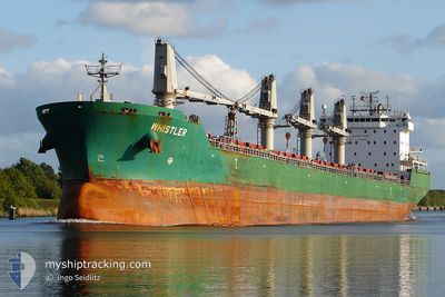
WHISTLER
Bulk Carrier
Current Trip
| Time Travelled | 25 days |
|---|---|
| Remaining Time | --- |
| Distance Travelled | 5448.45 nm |
| Remaining Distance | --- |
| AVG Speed | 10.5 Knop |
| MAX Speed | 13 Knop |
| AVG Wind | 10.9 knots |
| MAX Wind | 25 knots |
| MIN Temp | 10.6°C / 51.08°F |
| MAX Temp | 30.1°C / 86.18°F |
| Djupgående | 10.3 m |
| Position mottagen | 3 d sen |
Current Position
| Longitud | -96.04568° |
|---|---|
| Latitude | 19.14868° |
| Status | At anchor |
| Fart | |
| Kurs | 73° |
| Område | Gulf of Mexico |
| Station | T-AIS |
| Position mottagen | 3 d sen |
Info
Information
The current position of WHISTLER is in Gulf of Mexico with coordinates 19.14868° / -96.04568° as reported on 2024-06-06 23:54 by AIS to our vessel tracker app. The vessel's current speed is 0 Knop
The vessel WHISTLER (IMO: 9358371, MMSI: 538010692) is a Bulk Carrier that was built in 2007 ( 17 År gammal ). It's sailing under the flag of [MH] Marshall Is.
In this page you can find informations about the vessels current position, last detected port calls, and current voyage information. If the vessels is not in coverage by AIS you will find the latest position.
The current position of WHISTLER is detected by our AIS receivers and we are not responsible for the reliability of the data. The last position was recorded while the vessel was in Coverage by the Ais receivers of our vessel tracking app.
The current draught of WHISTLER as reported by AIS is 10.3 meters
Weather
| Temperature | 28.6°C / 83.48°F |
|---|---|
| Wind Speed | 8 knots |
| Direction | 119° ESE |
| Pressure | 1009.7 hPa |
| Humidity | 87.9 % |
| Cloud Coverage | 52 % |
Featured Company
Events
| Tid | Event | Detaljer | Position / Dest | Information |
|---|---|---|---|---|
| 2024-06-06 23:54 | UTANFÖR täckningsområde |
19.14868 / -96.04568
Gulf of Mexico
|
Fart: Kurs: 161° |
|
| 2024-06-06 23:36 | I täckningsområde |
19.14855 / -96.04566
Gulf of Mexico
|
Fart: 0.1 kn Kurs: 161° |
|
| 2024-06-06 03:18 | UTANFÖR täckningsområde |
19.14924 / -96.04564
Gulf of Mexico
|
Fart: Kurs: 356.8° |
|
| 2024-06-06 03:15 | ETA ändrat | 2024/06/05 06:00 2024/06/04 19:00 |
19.14933 / -96.04567
VERACRUZ
|
Fart: Kurs: 93° |
| 2024-06-06 03:06 | Status ändrad | At anchor Default |
19.14928 / -96.04573
VERACRUZ
|
Fart: Kurs: -1° |
| 2024-06-06 02:52 | Status ändrad | Default At anchor |
19.14833 / -96.04500
VERACRUZ
|
Fart: Kurs: 92° |
| 2024-06-06 02:12 | I täckningsområde |
19.14939 / -96.04574
Gulf of Mexico
|
Fart: Kurs: 299.1° |
|
| 2024-06-05 04:18 | STOPPAR förflyttning | 4.6 nm, North East of BOCA DEL RIO |
19.15058 / -96.04247
VERACRUZ
|
Fart: 0.3 kn Kurs: 192° |
| 2024-06-04 00:43 | Status ändrad | Default Under way using engine |
22.50686 / -92.06734
VERACRUZ
|
Fart: 11.1 kn Kurs: 237.7° |
| 2024-06-04 00:39 | UTANFÖR täckningsområde |
22.51415 / -92.05522
Gulf of Mexico
VERACRUZ
|
Fart: 11.1 kn Kurs: 237.7° |