
TUNA
Cargo
Current Trip
| Time Travelled | 6 days |
|---|---|
| Remaining Time | --- |
| Distance Travelled | 386.31 nm |
| Remaining Distance | --- |
| AVG Speed | 5.9 Knop |
| MAX Speed | 7 Knop |
| AVG Wind | 6.4 knots |
| MAX Wind | 17.8 knots |
| MIN Temp | 8.8°C / 47.84°F |
| MAX Temp | 24.1°C / 75.38°F |
| Djupgående | 1.6 m |
| Position mottagen | 4 h, 29 m sen |
Current Position
| Longitud | 20.36355° |
|---|---|
| Latitude | 44.87588° |
| Status | Under way using engine |
| Fart | 6.7 Knop |
| Kurs | 323.1° |
| Område | Black Sea |
| Station | T-AIS |
| Position mottagen | 4 h, 29 m sen |
Info
Information
The current position of TUNA is in Black Sea with coordinates 44.87588° / 20.36355° as reported on 2024-05-23 05:40 by AIS to our vessel tracker app. The vessel's current speed is 6.7 Knop
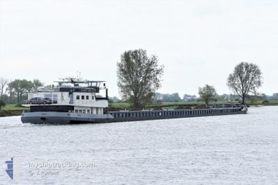
The vessel TUNA (MMSI: 244129081) is a Cargo It's sailing under the flag of [NL] Netherlands.
In this page you can find informations about the vessels current position, last detected port calls, and current voyage information. If the vessels is not in coverage by AIS you will find the latest position.
The current position of TUNA is detected by our AIS receivers and we are not responsible for the reliability of the data. The last position was recorded while the vessel was in Coverage by the Ais receivers of our vessel tracking app.
The current draught of TUNA as reported by AIS is 1.6 meters
Weather
| Temperature | 14°C / 57.2°F |
|---|---|
| Wind Speed | 10 knots |
| Direction | 258° WSW |
| Pressure | 1015.2 hPa |
| Humidity | 94.9 % |
| Cloud Coverage | 100 % |
Featured Company
Last Port Calls
| Port | Arrival | Departure | Time In Port |
|---|---|---|---|
| 2024-05-16 20:35 | |||
| 2024-05-05 09:16 | 2024-05-12 11:13 | 7 d | |
| 2024-05-04 18:30 | 2024-05-05 03:02 | 8 h | |
| 2024-04-16 12:47 | 2024-04-28 04:41 | 11 d | |
| 2024-03-21 18:22 | 2024-04-03 09:37 | 12 d | |
| 2024-03-19 15:53 | |||
| 2024-03-02 20:40 | 2024-03-09 22:39 | 7 d |
Last Trips
| Origin | Departure | Destination | Arrival | Distance | |
|---|---|---|---|---|---|
| 2024-05-05 06:02 | 2024-05-05 12:16 | 15.53 nm | |||
| 2024-04-28 06:41 | 2024-05-04 21:30 | 428.34 nm | |||
| 2024-04-03 12:37 | 2024-04-16 14:47 | 446.70 nm | |||
| 2024-03-19 17:53 | 2024-03-21 20:22 | 240.81 nm | |||
| 2024-02-02 18:10 | 2024-03-02 22:40 | 798.27 nm |
Events
| Tid | Event | Detaljer | Position / Dest | Information |
|---|---|---|---|---|
| 2024-05-23 05:40 | Status ändrad | Default Under way using engine |
44.87667 / 20.36167
PANCEVO
|
Fart: 6.7 kn Kurs: 323.1° |
| 2024-05-23 05:40 | UTANFÖR täckningsområde |
44.87588 / 20.36355
Black Sea
|
Fart: 6.7 kn Kurs: 323.1° |
|
| 2024-05-23 04:19 | Djupgående ändrat | 1.6 3.2 |
44.83404 / 20.53716
PANCEVO
|
Fart: 6.4 kn Kurs: 249.5° |
| 2024-05-23 04:19 | Destination ändrad | PANCEVO CONSTANTA |
44.83404 / 20.53716
PANCEVO
|
Fart: 6.4 kn Kurs: 249.5° |
| 2024-05-23 04:19 | Status ändrad | Under way using engine Default |
44.83450 / 20.53870
CONSTANTA
|
Fart: 6 kn Kurs: 252° |
| 2024-05-23 04:19 | I täckningsområde |
44.83395 / 20.53681
Black Sea
|
Fart: 6.4 kn Kurs: 250.3° |
|
| 2024-05-19 18:49 | STARTAR förflyttning | 3.81 nm, West of LOM |
43.81333 / 23.15833
CONSTANTA
|
Fart: 6 kn Kurs: 238° |
| 2024-05-16 20:35 | AVGÅTT HAMN |
|
44.17500 / 27.53833
CONSTANTA
|
Fart: Kurs: -1° |