
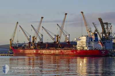
REK ELITE
Bulk Carrier
Current Trip
| Time Travelled | 3 days |
|---|---|
| Remaining Time | --- |
| Distance Travelled | 417.99 nm |
| Remaining Distance | --- |
| AVG Speed | 9.5 Knopen |
| MAX Speed | 11.3 Knopen |
| AVG Wind | 9 knots |
| MAX Wind | 15.3 knots |
| MIN Temp | 22.3°C / 72.14°F |
| MAX Temp | 25°C / 77°F |
| Diepgang | 9.6 M |
| Positie ontvangen | 1 m geleden |
Current Position
| Lengtegraad | 29.04427° |
|---|---|
| Breedtegraat | 41.35140° |
| Status | Under way using engine |
| Snelheid | 7.8 Knopen |
| Koers | 352° |
| Gebied | Black Sea |
| Station | T-AIS |
| Positie ontvangen | 1 m geleden |
Info
Information
The current position of REK ELITE is in Black Sea with coordinates 41.35140° / 29.04427° as reported on 2024-06-14 09:45 by AIS to our vessel tracker app. The vessel's current speed is 7.8 Knopen and is heading at the port of PORT SAID. The estimated time of arrival as calculated by MyShipTracking vessel tracking app is 2024-06-17 12:00 LT
The vessel REK ELITE (IMO: 9498626, MMSI: 373526000) is a Bulk Carrier that was built in 2012 ( 12 Jaar oud ). It's sailing under the flag of [PA] Panama.
In this page you can find informations about the vessels current position, last detected port calls, and current voyage information. If the vessels is not in coverage by AIS you will find the latest position.
The current position of REK ELITE is detected by our AIS receivers and we are not responsible for the reliability of the data. The last position was recorded while the vessel was in Coverage by the Ais receivers of our vessel tracking app.
The current draught of REK ELITE as reported by AIS is 9.6 meters
Weather
| Temperature | 24.3°C / 75.74°F |
|---|---|
| Wind Speed | 6 knots |
| Direction | 19° NNE |
| Pressure | 1009.4 hPa |
| Humidity | 77.4 % |
| Cloud Coverage | 100 % |
Featured Company
Last Port Calls
| Port | Arrival | Departure | Time In Port |
|---|---|---|---|
| 2024-06-11 06:01 | |||
| 2024-06-03 00:35 | 2024-06-04 11:27 | 1 d | |
| 2024-06-02 10:05 | 2024-06-02 23:39 | 13 h | |
| 2024-05-17 07:08 | 2024-05-23 13:44 | 6 d | |
| 2024-05-11 06:11 | 2024-05-11 15:23 | 9 h | |
| 2024-04-23 02:03 | 2024-04-24 20:56 | 1 d | |
| 2024-04-18 06:43 | 2024-04-21 04:32 | 2 d |
Most Visited Ports (Last year)
| Port | Arrivals | |
|---|---|---|
| 3 | ||
| 2 | ||
| 2 | ||
| 2 | ||
| 1 | ||
| 1 |
Last Trips
| Origin | Departure | Destination | Arrival | Distance | |
|---|---|---|---|---|---|
| 2024-06-03 02:39 | 2024-06-03 03:35 | 17.75 nm | |||
| 2024-05-23 15:44 | 2024-06-02 13:05 | 1777.81 nm | |||
| 2024-04-25 02:26 | 2024-05-17 09:08 | 5442.29 nm | |||
| 2024-04-25 02:26 | 2024-05-11 08:11 | 4035.99 nm | |||
| 2024-04-21 10:02 | 2024-04-23 07:33 | 323.41 nm | |||
| 2024-03-02 05:42 | 2024-04-18 12:13 | 4093.08 nm |
Events
| Tijd | Evenement | Details | Positie / Bestemming | Info |
|---|---|---|---|---|
| 2024-06-14 09:07 | Start beweging | 6.97 nm, North of RUMELI FENERI |
41.34237 / 29.06773
PORT SAID
|
Snelheid: 3.2 kn Koers: 150° |
| 2024-06-14 08:53 | Status Changed | Under way using engine Not under command |
41.34858 / 29.06293
PORT SAID
|
Snelheid: 1.1 kn Koers: 88° |
| 2024-06-13 17:43 | Stop beweging | 12.78 nm, North of RUMELI FENERI |
41.44310 / 29.14423
PORT SAID
|
Snelheid: 0.3 kn Koers: 338° |
| 2024-06-13 16:57 | Status Changed | Not under command Under way using engine |
41.44707 / 29.16565
PORT SAID
|
Snelheid: 4.4 kn Koers: 263° |
| 2024-06-13 15:28 | Gevonden in zee | Turkish part of the Black Sea |
41.49867 / 29.45530
Black Sea
PORT SAID
|
Snelheid: 10.7 kn Koers: 249° |
| 2024-06-13 15:28 | Status Changed | Under way using engine Default |
41.49937 / 29.45780
PORT SAID
|
Snelheid: 10.8 kn Koers: 249° |
| 2024-06-13 15:17 | Binnenbereik |
41.49867 / 29.45530
Black Sea
PORT SAID
|
Snelheid: 10.7 kn Koers: 249° |
|
| 2024-06-12 12:33 | Status Changed | Default Under way using engine |
43.70526 / 35.39380
PORT SAID
|
Snelheid: 10.7 kn Koers: 246.6° |
| 2024-06-12 12:27 | Gevonden in zee | Ukrainian part of the Black Sea |
43.71290 / 35.41574
Black Sea
PORT SAID
|
Snelheid: 10.7 kn Koers: 246.6° |
| 2024-06-12 12:27 | Buitenbereik |
43.71290 / 35.41574
Black Sea
PORT SAID
|
Snelheid: 10.7 kn Koers: 246.6° |