
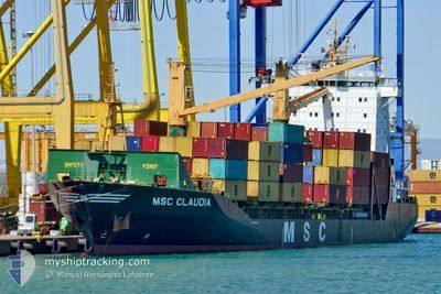
MSC CLAUDIA
Container Ship
Current Trip
| Time Travelled | 4 days |
|---|---|
| Remaining Time | 1 day |
| Distance Travelled | 841.29 nm |
| Remaining Distance | 424.71 nm |
| AVG Speed | 12.8 Knopen |
| MAX Speed | 12.8 Knopen |
| AVG Wind | 7.8 knots |
| MAX Wind | 22.4 knots |
| MIN Temp | 21.6°C / 70.88°F |
| MAX Temp | 30.2°C / 86.36°F |
| Diepgang | 9 M |
| Positie ontvangen | 1 m geleden |
Current Position
| Lengtegraad | 29.51240° |
|---|---|
| Breedtegraat | 41.38851° |
| Status | Under way using engine |
| Snelheid | 10.7 Knopen |
| Koers | 67.3° |
| Gebied | Black Sea |
| Station | T-AIS |
| Positie ontvangen | 1 m geleden |
Info
Information
The current position of MSC CLAUDIA is in Black Sea with coordinates 41.38851° / 29.51240° as reported on 2024-06-14 15:20 by AIS to our vessel tracker app. The vessel's current speed is 10.7 Knopen and is heading at the port of NOVOROSSIYSK. The estimated time of arrival as calculated by MyShipTracking vessel tracking app is 2024-06-16 06:46 LT
The vessel MSC CLAUDIA (IMO: 9113446, MMSI: 636018573) is a Container Ship that was built in 1996 ( 28 Jaar oud ). It's sailing under the flag of [LR] Liberia.
In this page you can find informations about the vessels current position, last detected port calls, and current voyage information. If the vessels is not in coverage by AIS you will find the latest position.
The current position of MSC CLAUDIA is detected by our AIS receivers and we are not responsible for the reliability of the data. The last position was recorded while the vessel was in Coverage by the Ais receivers of our vessel tracking app.
The current draught of MSC CLAUDIA as reported by AIS is 9 meters
Weather
| Temperature | 21.5°C / 70.7°F |
|---|---|
| Wind Speed | 24 knots |
| Direction | 338° NNW |
| Pressure | 1009.2 hPa |
| Humidity | 89.3 % |
| Cloud Coverage | 43 % |
Featured Company
Last Port Calls
| Port | Arrival | Departure | Time In Port |
|---|---|---|---|
| 2024-06-10 00:53 | 2024-06-10 12:17 | 11 h | |
| 2024-06-04 10:00 | 2024-06-05 11:46 | 1 d | |
| 2024-06-02 23:04 | 2024-06-03 08:38 | 9 h | |
| 2024-06-01 21:07 | 2024-06-02 12:26 | 15 h | |
| 2024-05-29 17:58 | 2024-05-30 18:32 | 1 d | |
| 2024-05-27 22:39 | 2024-05-27 23:50 | 1 h | |
| 2024-05-27 22:20 | 2024-05-27 22:24 | 4 m | |
| 2024-05-27 20:53 | 2024-05-27 22:14 | 1 h | |
| 2024-05-27 09:13 | 2024-05-27 20:29 | 11 h | |
| 2024-05-27 06:55 | 2024-05-27 09:08 | 2 h |
Last Trips
| Origin | Departure | Destination | Arrival | Distance | |
|---|---|---|---|---|---|
| 2024-06-05 14:46 | 2024-06-10 02:53 | 598.28 nm | |||
| 2024-06-03 11:38 | 2024-06-04 13:00 | 477.50 nm | |||
| 2024-06-02 15:26 | 2024-06-03 02:04 | 103.88 nm | |||
| 2024-05-30 21:32 | 2024-06-02 00:07 | 349.49 nm | |||
| 2024-05-28 02:50 | 2024-05-29 20:58 | 415.86 nm | |||
| 2024-05-28 01:24 | 2024-05-28 01:39 | 0.54 nm | |||
| 2024-05-28 01:14 | 2024-05-28 01:20 | 0.60 nm | |||
| 2024-05-27 23:29 | 2024-05-27 23:53 | 2.49 nm | |||
| 2024-05-27 12:08 | 2024-05-27 12:13 | 0.83 nm | |||
| 2024-05-25 11:48 | 2024-05-27 09:55 | 801.06 nm |
Events
| Tijd | Evenement | Details | Positie / Bestemming | Info |
|---|---|---|---|---|
| 2024-06-14 13:32 | Wijzig zee gebeid | Turkish part of the Black Sea Turkish part of the Sea of Marmara |
41.22958 / 29.14407
Black Sea
RUNVS
|
Snelheid: 10.2 kn Koers: 39.8° |
| 2024-06-14 09:45 | Start beweging | 11.6 nm, South of YESILKOY |
40.76244 / 28.84378
RUNVS
|
Snelheid: 3.1 kn Koers: 251.5° |
| 2024-06-14 05:51 | Stop beweging | 8.49 nm, South East of YESILKOY |
40.83076 / 28.91426
RUNVS
|
Snelheid: 0.3 kn Koers: 10° |
| 2024-06-14 04:54 | Start beweging | 13.35 nm, South of YESILKOY |
40.74327 / 28.91472
RUNVS
|
Snelheid: 3.1 kn Koers: 256° |
| 2024-06-13 23:51 | Stop beweging | 13.15 nm, South of YESILKOY |
40.74465 / 28.90576
RUNVS
|
Snelheid: 0.3 kn Koers: 511° |
| 2024-06-13 20:03 | ETA Changed | 2024/06/15 17:00 2024/06/15 12:00 |
40.69638 / 28.77039
RUNVS
|
Snelheid: 0.8 kn Koers: 511° |
| 2024-06-13 12:04 | Status Changed | Under way using engine At anchor |
40.84302 / 28.78092
RUNVS
|
Snelheid: 7.5 kn Koers: 205.1° |
| 2024-06-13 11:10 | Start beweging | 1.3 nm, South East of YESILKOY |
40.93678 / 28.84044
RUNVS
|
Snelheid: 4.5 kn Koers: 207° |
| 2024-06-13 07:49 | Status Changed | At anchor Under way using engine |
40.93841 / 28.84320
RUNVS
|
Snelheid: 0.2 kn Koers: 511° |
| 2024-06-13 07:37 | Stop beweging | 1.31 nm, South East of YESILKOY |
40.93794 / 28.84289
RUNVS
|
Snelheid: 0.1 kn Koers: 287° |