
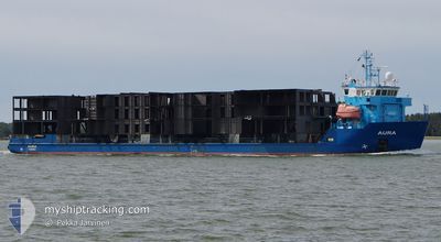
AURA
Cable Layer
Current Trip
| Time Travelled | 9 h, 40 mins |
|---|---|
| Remaining Time | --- |
| Distance Travelled | 105.25 nm |
| Remaining Distance | --- |
| AVG Speed | 10.7 Knopen |
| MAX Speed | 11.2 Knopen |
| AVG Wind | 6.8 knots |
| MAX Wind | 9.2 knots |
| MIN Temp | 2.3°C / 36.14°F |
| MAX Temp | 4.3°C / 39.74°F |
| Diepgang | 3.9 M |
| Positie ontvangen | 1 m geleden |
Current Position
| Lengtegraad | 19.04486° |
|---|---|
| Breedtegraat | 60.29552° |
| Status | Under way using engine |
| Snelheid | 10.3 Knopen |
| Koers | 182.3° |
| Gebied | Gulf of Bothnia |
| Station | T-AIS |
| Positie ontvangen | 1 m geleden |
Info
Information
The current position of AURA is in Gulf of Bothnia with coordinates 60.29552° / 19.04486° as reported on 2024-05-09 08:47 by AIS to our vessel tracker app. The vessel's current speed is 10.3 Knopen and is heading at the port of EGERSUND. The estimated time of arrival as calculated by MyShipTracking vessel tracking app is 2024-05-11 10:00 LT
The vessel AURA (IMO: 9395276, MMSI: 230601000) is a Cable Layer that was built in 2008 ( 16 Jaar oud ). It's sailing under the flag of [FI] Finland.
In this page you can find informations about the vessels current position, last detected port calls, and current voyage information. If the vessels is not in coverage by AIS you will find the latest position.
The current position of AURA is detected by our AIS receivers and we are not responsible for the reliability of the data. The last position was recorded while the vessel was in Coverage by the Ais receivers of our vessel tracking app.
The current draught of AURA as reported by AIS is 3.9 meters
Weather
| Temperature | 4.2°C / 39.56°F |
|---|---|
| Wind Speed | 8 knots |
| Direction | 184° S |
| Pressure | 1022 hPa |
| Humidity | 85.8 % |
| Cloud Coverage | 86 % |
Featured Company
Last Port Calls
| Port | Arrival | Departure | Time In Port |
|---|---|---|---|
| 2024-05-06 09:24 | 2024-05-08 23:08 | 2 d | |
| 2024-05-02 21:16 | 2024-05-03 14:10 | 16 h | |
| 2024-04-30 06:14 | 2024-04-30 21:04 | 14 h | |
| 2024-04-27 19:40 | 2024-04-29 17:56 | 1 d | |
| 2024-04-27 17:05 | 2024-04-27 17:09 | 3 m | |
| 2024-04-24 20:40 | 2024-04-25 15:28 | 18 h | |
| 2024-04-19 04:47 | 2024-04-20 10:43 | 1 d | |
| 2024-04-17 04:04 | 2024-04-17 16:09 | 12 h | |
| 2024-04-09 10:18 | 2024-04-11 14:03 | 2 d | |
| 2024-03-25 19:45 | 2024-04-02 12:45 | 7 d |
Last Trips
| Origin | Departure | Destination | Arrival | Distance | |
|---|---|---|---|---|---|
| 2024-05-03 16:10 | 2024-05-06 12:24 | 716.38 nm | |||
| 2024-04-30 23:04 | 2024-05-02 23:16 | 462.35 nm | |||
| 2024-04-29 19:56 | 2024-04-30 08:14 | 93.83 nm | |||
| 2024-04-27 19:09 | 2024-04-27 21:40 | 11.48 nm | |||
| 2024-04-25 17:28 | 2024-04-27 19:05 | 457.50 nm | |||
| 2024-04-20 13:43 | 2024-04-24 22:40 | 835.28 nm | |||
| 2024-04-17 18:09 | 2024-04-19 07:47 | 337.48 nm | |||
| 2024-04-11 15:03 | 2024-04-17 06:04 | 1289.69 nm | |||
| 2024-04-02 14:45 | 2024-04-09 11:18 | 1282.43 nm | |||
| 2024-03-20 10:58 | 2024-03-25 20:45 | 1420.89 nm |
Events
| Tijd | Evenement | Details | Positie / Bestemming | Info |
|---|---|---|---|---|
| 2024-05-09 08:17 | Draught Changed | 3.9 3.8 |
60.37415 / 19.12963
NOEGE
|
Snelheid: 10.9 kn Koers: 211.4° |
| 2024-05-09 08:17 | Destination Changed | NOEGE FIPOR |
60.37415 / 19.12963
NOEGE
|
Snelheid: 10.9 kn Koers: 211.4° |
| 2024-05-09 08:17 | ETA Changed | 2024/05/11 10:00 2024/05/06 15:00 |
60.37415 / 19.12963
NOEGE
|
Snelheid: 10.9 kn Koers: 211.4° |
| 2024-05-09 08:07 | Wijzig zee gebeid | Swedish part of the Gulf of Bothnia Finnish part of the Gulf of Bothnia |
60.39928 / 19.16027
Gulf of Bothnia
|
Snelheid: 10.9 kn Koers: 211° |
| 2024-05-09 08:00 | Wijzig zee gebeid | Finnish part of the Gulf of Bothnia Swedish part of the Gulf of Bothnia |
60.41564 / 19.18008
Gulf of Bothnia
|
Snelheid: 10.8 kn Koers: 211.4° |
| 2024-05-09 08:00 | Status Changed | Under way using engine Default |
60.41564 / 19.18008
FIPOR
|
Snelheid: 10.8 kn Koers: 212° |
| 2024-05-09 08:00 | Binnenbereik |
60.41564 / 19.18008
Gulf of Bothnia
|
Snelheid: 10.8 kn Koers: 211.4° |
|
| 2024-05-08 23:08 | Vertrekhaven |
|
61.59505 / 21.45223
FIPOR
|
Snelheid: 4.4 kn Koers: 259° |
| 2024-05-08 23:04 | Start beweging |
61.60066 / 21.46259
[FI] MANTYLUOTO
|
Snelheid: 4.4 kn Koers: 259° |
|
| 2024-05-06 09:24 | Stop beweging |
61.59957 / 21.46732
[FI] MANTYLUOTO
|
Snelheid: Koers: 338° |