
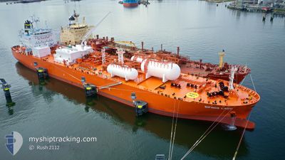
SIFNOS LADY
Tanker
Current Trip
| Time Travelled | 7 days |
|---|---|
| Remaining Time | --- |
| Distance Travelled | 2311.80 nm |
| Remaining Distance | --- |
| AVG Speed | 12.9 Noeuds |
| MAX Speed | 18 Noeuds |
| AVG Wind | 14.1 knots |
| MAX Wind | 28 knots |
| MIN Temp | 8.8°C / 47.84°F |
| MAX Temp | 30.3°C / 86.54°F |
| Tirant d eau | 10.3 m |
| Position reçue | 6 d depuis |
Current Position
| Longitude | -70.43041° |
|---|---|
| Latitude | 37.82684° |
| Etat | Under way using engine |
| Vitesse | 15.4 Noeuds |
| Parcours | 90.8° |
| Zone | North Atlantic Ocean |
| Station | T-AIS |
| Position reçue | 6 d depuis |
Info
Information
The current position of SIFNOS LADY is in North Atlantic Ocean with coordinates 37.82684° / -70.43041° as reported on 2024-05-27 19:57 by AIS to our vessel tracker app. The vessel's current speed is 15.4 Noeuds and is heading at the port of VLISSINGEN. The estimated time of arrival as calculated by MyShipTracking vessel tracking app is 2024-06-07 19:00 LT
The vessel SIFNOS LADY (IMO: 9903073, MMSI: 563137100) is a Tanker It's sailing under the flag of [SG] Singapore.
In this page you can find informations about the vessels current position, last detected port calls, and current voyage information. If the vessels is not in coverage by AIS you will find the latest position.
The current position of SIFNOS LADY is detected by our AIS receivers and we are not responsible for the reliability of the data. The last position was recorded while the vessel was in Coverage by the Ais receivers of our vessel tracking app.
The current draught of SIFNOS LADY as reported by AIS is 10.3 meters
Weather
| Temperature | 12.8°C / 55.04°F |
|---|---|
| Wind Speed | 11 knots |
| Direction | 87° E |
| Pressure | 1032.1 hPa |
| Humidity | 80.6 % |
| Cloud Coverage | 94 % |
Featured Company
Last Port Calls
| Port | Arrival | Departure | Time In Port |
|---|---|---|---|
| 2024-05-24 22:58 | 2024-05-26 04:21 | 1 d | |
| 2024-05-07 19:44 | 2024-05-09 19:32 | 1 d | |
| 2024-04-20 00:58 | 2024-04-21 02:26 | 1 d | |
| 2024-04-05 08:51 | 2024-04-07 08:58 | 2 d |
Last Trips
| Origin | Departure | Destination | Arrival | Distance | |
|---|---|---|---|---|---|
| 2024-05-09 19:32 | 2024-05-24 22:58 | 4494.58 nm | |||
| 2024-04-21 02:26 | 2024-05-07 19:44 | 4675.24 nm | |||
| 2024-04-07 08:58 | 2024-04-20 00:58 | 3594.39 nm | |||
| 2024-03-23 07:07 | 2024-04-05 08:51 | 3603.84 nm |
Events
| Heure | Evenement | Détails | Position/ Destination | Info |
|---|---|---|---|---|
| 2024-05-27 20:04 | Etat Changé | Default Under way using engine |
37.82500 / -70.38834
NL VLI
|
Vitesse: 15.4 kn Parcours: 90.8° |
| 2024-05-27 19:57 | Hors de la zone couverte |
37.82684 / -70.43041
North Atlantic Ocean
NL VLI
|
Vitesse: 15.4 kn Parcours: 90.8° |
|
| 2024-05-27 19:52 | Etat Changé | Under way using engine Default |
37.82726 / -70.45524
NL VLI
|
Vitesse: 16 kn Parcours: 89° |
| 2024-05-27 19:44 | Etat Changé | Default Under way using engine |
37.82745 / -70.50282
NL VLI
|
Vitesse: 16.8 kn Parcours: 89.9° |
| 2024-05-27 19:28 | Changement de zone | High seas of the North Atlantic Ocean United States part of the North Atlantic Ocean |
37.82780 / -70.59794
North Atlantic Ocean
NL VLI
|
Vitesse: 16.5 kn Parcours: 90.8° |
| 2024-05-27 18:24 | Tirant d'eau modifié | 10.3 10.2 |
37.86525 / -70.95368
NL VLI
|
Vitesse: 15.1 kn Parcours: 96.6° |
| 2024-05-27 16:10 | Etat Changé | Under way using engine Default |
37.95674 / -71.64106
NL VLI
|
Vitesse: 14 kn Parcours: 99° |
| 2024-05-27 15:55 | Dans la zone couverte |
37.95674 / -71.64106
North Atlantic Ocean
NL VLI
|
Vitesse: 14.8 kn Parcours: 100.5° |
|
| 2024-05-27 07:03 | Etat Changé | Default Under way using engine |
38.32286 / -74.29079
NL VLI
|
Vitesse: 13.8 kn Parcours: 96.8° |
| 2024-05-27 06:55 | Hors de la zone couverte |
38.32674 / -74.33123
North Atlantic Ocean
NL VLI
|
Vitesse: 13.8 kn Parcours: 96.8° |