
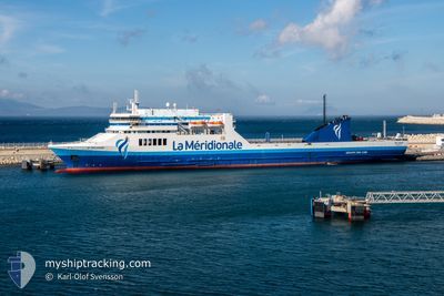
PELAGOS
Ro-Ro/Passenger Ship
Current Trip
| Trip Time | 1 day |
|---|---|
| Trip Distance | 737.21 nm |
| AVG Speed | 17.3 Noeuds |
| MAX Speed | 22.8 Noeuds |
| Tirant d eau | 5.9 m |
| AVG Wind | 10.8 knots |
| MAX Wind | 19.8 knots |
| MIN Temp | 17.4°C / 63.32°F |
| MAX Temp | 22°C / 71.6°F |
| Position reçue | 2 m depuis |
Current Position
| Longitude | 5.34096° |
|---|---|
| Latitude | 43.33918° |
| Etat | Moored |
| Vitesse | |
| Parcours | 274° |
| Zone | Mediterranean Sea - Western Basin |
| Station | T-AIS |
| Position reçue | 2 m depuis |
Info
Information
The current position of PELAGOS is in Mediterranean Sea - Western Basin with coordinates 43.33918° / 5.34096° as reported on 2024-05-30 15:42 by AIS to our vessel tracker app. The vessel's current speed is 0 Noeuds and is currently inside the port of MARSEILLE.
The vessel PELAGOS (IMO: 9136034, MMSI: 228393700) is a Ro-Ro/Passenger Ship that was built in 1997 ( 27 Age ). It's sailing under the flag of [FR] France.
In this page you can find informations about the vessels current position, last detected port calls, and current voyage information. If the vessels is not in coverage by AIS you will find the latest position.
The current position of PELAGOS is detected by our AIS receivers and we are not responsible for the reliability of the data. The last position was recorded while the vessel was in Coverage by the Ais receivers of our vessel tracking app.
The current draught of PELAGOS as reported by AIS is 5.9 meters
Weather
| Temperature | 21.2°C / 70.16°F |
|---|---|
| Wind Speed | 24 knots |
| Direction | 276° W |
| Pressure | 1007.4 hPa |
| Humidity | 66.1 % |
| Cloud Coverage | 22 % |
Featured Company
Last Port Calls
| Port | Arrival | Departure | Time In Port |
|---|---|---|---|
| 2024-05-29 14:26 | |||
| 2024-05-27 11:55 | 2024-05-27 19:17 | 7 h | |
| 2024-05-24 12:31 | 2024-05-25 15:46 | 1 d | |
| 2024-05-22 12:14 | 2024-05-22 19:21 | 7 h | |
| 2024-05-20 12:47 | 2024-05-20 21:00 | 8 h | |
| 2024-05-18 11:54 | 2024-05-18 19:51 | 7 h | |
| 2024-05-15 12:59 | 2024-05-16 19:28 | 1 d | |
| 2024-05-13 12:02 | 2024-05-13 19:46 | 7 h | |
| 2024-05-10 13:16 | 2024-05-11 14:55 | 1 d | |
| 2024-05-08 12:35 | 2024-05-08 18:54 | 6 h |
Most Visited Ports (Last year)
| Port | Arrivals | |
|---|---|---|
| 53 | ||
| 47 | ||
| 6 | ||
| 5 | ||
| 5 | ||
| 3 |
Last Trips
| Origin | Departure | Destination | Arrival | Distance | |
|---|---|---|---|---|---|
| 2024-05-27 19:17 | 2024-05-29 14:26 | 737.21 nm | |||
| 2024-05-25 15:46 | 2024-05-27 11:55 | 712.42 nm | |||
| 2024-05-22 19:21 | 2024-05-24 12:31 | 715.74 nm | |||
| 2024-05-20 21:00 | 2024-05-22 12:14 | 711.19 nm | |||
| 2024-05-18 19:51 | 2024-05-20 12:47 | 712.91 nm | |||
| 2024-05-16 19:28 | 2024-05-18 11:54 | 712.90 nm | |||
| 2024-05-13 19:46 | 2024-05-15 12:59 | 712.71 nm | |||
| 2024-05-11 14:55 | 2024-05-13 12:02 | 713.94 nm | |||
| 2024-05-08 18:54 | 2024-05-10 13:16 | 711.97 nm | |||
| 2024-05-06 23:02 | 2024-05-08 12:35 | 719.53 nm |
Events
| Heure | Evenement | Détails | Position/ Destination | Info |
|---|---|---|---|---|
| 2024-05-29 13:26 | Changement de destination | MAPTM FRMRS |
43.33917 / 5.34096
[FR] MARSEILLE
|
Vitesse: Parcours: 274° |
| 2024-05-29 13:26 | Changement d'ETA | 2024/06/01 11:00 2024/05/29 13:00 |
43.33917 / 5.34096
[FR] MARSEILLE
|
Vitesse: Parcours: 274° |
| 2024-05-29 13:25 | Etat Changé | Moored Under way using engine |
43.33917 / 5.34096
[FR] MARSEILLE
|
Vitesse: Parcours: 274° |
| 2024-05-29 12:40 | Arret |
43.33720 / 5.33789
[FR] MARSEILLE
|
Vitesse: 0.3 kn Parcours: 211° |
|
| 2024-05-29 12:26 | Port d'arrivée |
|
43.34739 / 5.31140
[FR] MARSEILLE
|
Vitesse: 12.7 kn Parcours: 54.2° |
| 2024-05-29 11:19 | Etat Changé | Under way using engine Default |
43.18357 / 5.07709
FRMRS
|
Vitesse: 12.6 kn Parcours: 57° |
| 2024-05-29 11:02 | Dans la zone couverte |
43.18357 / 5.07709
Mediterranean Sea - Western Basin
FRMRS
|
Vitesse: 12.8 kn Parcours: 50° |
|
| 2024-05-29 08:50 | Etat Changé | Default Under way using engine |
43.06800 / 4.41363
FRMRS
|
Vitesse: 12.2 kn Parcours: 84.7° |
| 2024-05-29 08:39 | Hors de la zone couverte |
43.06434 / 4.36453
Mediterranean Sea - Western Basin
FRMRS
|
Vitesse: 12.2 kn Parcours: 84.7° |
|
| 2024-05-29 05:14 | Detecté en mer | French part of the Mediterranean Sea - Western Basin |
42.66409 / 3.64627
Mediterranean Sea - Western Basin
FRMRS
|
Vitesse: 16.6 kn Parcours: 16.2° |