
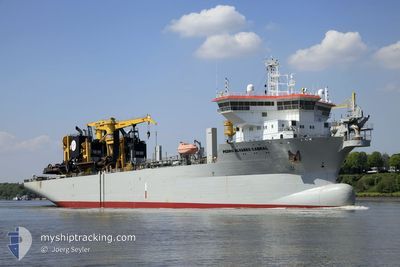
PEDRO ALVARES CABRAL
Trailing Suction Hopper Dredger
Current Trip
| Trip Time | 1 h, 19 mins |
|---|---|
| Trip Distance | 13.41 nm |
| AVG Speed | 10.1 Noeuds |
| MAX Speed | 15.5 Noeuds |
| Tirant d eau | 11.2 m |
| AVG Wind | 2.8 knots |
| MAX Wind | 3 knots |
| MIN Temp | 24.2°C / 75.56°F |
| MAX Temp | 25.7°C / 78.26°F |
| Position reçue | 4 m depuis |
Current Position
| Longitude | 34.64093° |
|---|---|
| Latitude | 36.79805° |
| Etat | Restricted manoeuverability |
| Vitesse | 1.5 Noeuds |
| Parcours | 214° |
| Zone | Mediterranean Sea - Eastern Basin |
| Station | T-AIS |
| Position reçue | 4 m depuis |
Info
Information
The current position of PEDRO ALVARES CABRAL is in Mediterranean Sea - Eastern Basin with coordinates 36.79805° / 34.64093° as reported on 2024-06-09 04:25 by AIS to our vessel tracker app. The vessel's current speed is 1.5 Noeuds and is currently inside the port of MERSIN.
The vessel PEDRO ALVARES CABRAL (IMO: 9606132, MMSI: 253365000) is a Trailing Suction Hopper Dredger that was built in 2012 ( 12 Age ). It's sailing under the flag of [LU] Luxembourg.
In this page you can find informations about the vessels current position, last detected port calls, and current voyage information. If the vessels is not in coverage by AIS you will find the latest position.
The current position of PEDRO ALVARES CABRAL is detected by our AIS receivers and we are not responsible for the reliability of the data. The last position was recorded while the vessel was in Coverage by the Ais receivers of our vessel tracking app.
The current draught of PEDRO ALVARES CABRAL as reported by AIS is 11.2 meters
Weather
| Temperature | 25.9°C / 78.62°F |
|---|---|
| Wind Speed | 3 knots |
| Direction | 42° NE |
| Pressure | 1003.9 hPa |
| Humidity | 50 % |
| Cloud Coverage | 36 % |
Featured Company
Last Port Calls
| Port | Arrival | Departure | Time In Port |
|---|---|---|---|
| 2024-06-09 05:04 | |||
| 2024-06-09 01:33 | 2024-06-09 03:45 | 2 h | |
| 2024-06-08 22:01 | 2024-06-09 00:16 | 2 h | |
| 2024-06-08 17:49 | 2024-06-08 19:32 | 1 h | |
| 2024-06-08 13:38 | 2024-06-08 16:09 | 2 h | |
| 2024-06-08 10:07 | 2024-06-08 12:13 | 2 h | |
| 2024-06-08 07:58 | 2024-06-08 08:20 | 22 m | |
| 2024-06-08 04:17 | 2024-06-08 04:47 | 30 m | |
| 2024-06-08 02:58 | 2024-06-08 03:29 | 30 m | |
| 2024-06-07 23:37 | 2024-06-08 00:09 | 31 m |
Most Visited Ports (Last year)
| Port | Arrivals | |
|---|---|---|
| 311 | ||
| 308 | ||
| 57 | ||
| 44 | ||
| 3 | ||
| 3 |
Last Trips
| Origin | Departure | Destination | Arrival | Distance | |
|---|---|---|---|---|---|
| 2024-06-09 03:45 | 2024-06-09 05:04 | 13.41 nm | |||
| 2024-06-09 00:16 | 2024-06-09 01:33 | 13.18 nm | |||
| 2024-06-08 19:32 | 2024-06-08 22:01 | 14.24 nm | |||
| 2024-06-08 16:09 | 2024-06-08 17:49 | 13.73 nm | |||
| 2024-06-08 12:13 | 2024-06-08 13:38 | 14.53 nm | |||
| 2024-06-08 08:20 | 2024-06-08 10:07 | 14.80 nm | |||
| 2024-06-08 04:47 | 2024-06-08 07:58 | 16.22 nm | |||
| 2024-06-08 03:29 | 2024-06-08 04:17 | 0.88 nm | |||
| 2024-06-08 00:09 | 2024-06-08 02:58 | 14.66 nm | |||
| 2024-06-07 21:53 | 2024-06-07 23:37 | 12.59 nm |
Events
| Heure | Evenement | Détails | Position/ Destination | Info |
|---|---|---|---|---|
| 2024-06-09 04:25 | Etat Changé | Restricted manoeuverability Default |
36.79836 / 34.64087
[TR] MERSIN
|
Vitesse: 1.1 kn Parcours: 19° |
| 2024-06-09 04:13 | Dans la zone couverte |
36.79805 / 34.64093
Mediterranean Sea - Eastern Basin
[TR] MERSIN
|
Vitesse: 1.5 kn Parcours: 162.3° |
|
| 2024-06-09 03:25 | Arret |
36.78979 / 34.63654
[TR] MERSIN
|
Vitesse: 0.3 kn Parcours: 42° |
|
| 2024-06-09 02:04 | Port d'arrivée |
|
36.78920 / 34.64139
[TR] MERSIN
|
Vitesse: 9.6 kn Parcours: 349° |
| 2024-06-09 01:25 | Etat Changé | Default Restricted manoeuverability |
36.68925 / 34.58201
TRMER
|
Vitesse: 0.5 kn Parcours: 56° |
| 2024-06-09 01:20 | Hors de la zone couverte |
36.68876 / 34.58097
Mediterranean Sea - Eastern Basin
[TR] MERSIN
|
Vitesse: 0.5 kn Parcours: 61.7° |
|
| 2024-06-09 01:10 | Etat Changé | Restricted manoeuverability Default |
36.69075 / 34.58734
TRMER
|
Vitesse: 15.5 kn Parcours: 210° |
| 2024-06-09 01:10 | Dans la zone couverte |
36.69075 / 34.58734
Mediterranean Sea - Eastern Basin
|
Vitesse: 10 kn Parcours: 213.8° |
|
| 2024-06-09 00:45 | PORT DE DEPART |
|
36.77388 / 34.65094
TRMER
|
Vitesse: 4.2 kn Parcours: 182° |
| 2024-06-08 22:49 | Hors de la zone couverte |
36.79651 / 34.64236
Mediterranean Sea - Eastern Basin
[TR] MERSIN
|
Vitesse: 1.3 kn Parcours: 359.5° |