
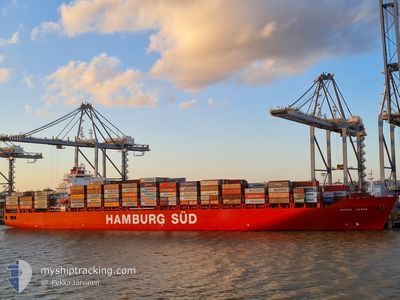
MONTE VERDE
Container Ship
Current Trip
| Time Travelled | 2 days |
|---|---|
| Remaining Time | --- |
| Distance Travelled | 333.27 nm |
| Remaining Distance | --- |
| AVG Speed | 10.8 Noeuds |
| MAX Speed | 17.8 Noeuds |
| AVG Wind | 10.4 knots |
| MAX Wind | 15.8 knots |
| MIN Temp | 11.3°C / 52.34°F |
| MAX Temp | 16.8°C / 62.24°F |
| Tirant d eau | 9.9 m |
| Position reçue | 5 h, 16 m depuis |
Current Position
| Longitude | -52.01326° |
|---|---|
| Latitude | -32.19325° |
| Etat | Under way using engine |
| Vitesse | 6.2 Noeuds |
| Parcours | 87.1° |
| Zone | South Atlantic Ocean |
| Station | T-AIS |
| Position reçue | 5 h, 16 m depuis |
Info
Information
The current position of MONTE VERDE is in South Atlantic Ocean with coordinates -32.19325° / -52.01326° as reported on 2024-06-06 15:51 by AIS to our vessel tracker app. The vessel's current speed is 6.2 Noeuds
The vessel MONTE VERDE (IMO: 9283239, MMSI: 563051800) is a Container Ship that was built in 2005 ( 19 Age ). It's sailing under the flag of [SG] Singapore.
In this page you can find informations about the vessels current position, last detected port calls, and current voyage information. If the vessels is not in coverage by AIS you will find the latest position.
The current position of MONTE VERDE is detected by our AIS receivers and we are not responsible for the reliability of the data. The last position was recorded while the vessel was in Coverage by the Ais receivers of our vessel tracking app.
The current draught of MONTE VERDE as reported by AIS is 9.9 meters
Weather
| Temperature | 16.6°C / 61.88°F |
|---|---|
| Wind Speed | 4 knots |
| Direction | 320° NW |
| Pressure | 1018.6 hPa |
| Humidity | 91.1 % |
| Cloud Coverage | 100 % |
Featured Company
Last Port Calls
| Port | Arrival | Departure | Time In Port |
|---|---|---|---|
| 2024-06-03 22:16 | 2024-06-04 17:48 | 19 h | |
| 2024-06-01 22:34 | 2024-06-02 16:42 | 18 h | |
| 2024-05-29 05:34 | 2024-05-30 00:06 | 18 h | |
| 2024-05-18 06:35 | 2024-05-18 23:45 | 17 h | |
| 2024-05-14 14:21 | 2024-05-15 07:49 | 17 h | |
| 2024-05-10 06:17 | 2024-05-10 22:24 | 16 h | |
| 2024-05-08 05:01 | 2024-05-09 01:10 | 20 h | |
| 2024-05-08 04:09 | 2024-05-08 04:15 | 5 m | |
| 2024-05-01 08:22 | 2024-05-07 04:18 | 5 d | |
| 2024-04-21 09:29 | 2024-04-21 18:11 | 8 h |
Most Visited Ports (Last year)
| Port | Arrivals | |
|---|---|---|
| 15 | ||
| 8 | ||
| 7 | ||
| 7 | ||
| 7 | ||
| 7 |
Last Trips
| Origin | Departure | Destination | Arrival | Distance | |
|---|---|---|---|---|---|
| 2024-06-02 13:42 | 2024-06-03 19:16 | 203.40 nm | |||
| 2024-05-29 21:06 | 2024-06-01 19:34 | 1011.91 nm | |||
| 2024-05-18 19:45 | 2024-05-29 02:34 | 4761.86 nm | |||
| 2024-05-15 03:49 | 2024-05-18 02:35 | 573.83 nm | |||
| 2024-05-10 18:24 | 2024-05-14 10:21 | 505.89 nm | |||
| 2024-05-08 21:10 | 2024-05-10 02:17 | 276.12 nm | |||
| 2024-05-08 00:15 | 2024-05-08 01:01 | 1.53 nm | |||
| 2024-05-07 00:18 | 2024-05-08 00:09 | 246.33 nm | |||
| 2024-04-21 15:11 | 2024-05-01 04:22 | 3305.06 nm | |||
| 2024-04-19 03:49 | 2024-04-21 06:29 | 842.00 nm |
Events
| Heure | Evenement | Détails | Position/ Destination | Info |
|---|---|---|---|---|
| 2024-06-06 15:51 | Hors de la zone couverte |
-32.19325 / -52.01326
South Atlantic Ocean
|
Vitesse: 6.2 kn Parcours: 87.1° |
|
| 2024-06-06 15:30 | Detecté en mer | Brazilian part of the South Atlantic Ocean |
-32.20293 / -52.01921
South Atlantic Ocean
|
Vitesse: 5.3 kn Parcours: 287.7° |
| 2024-06-06 15:30 | Dans la zone couverte |
-32.20293 / -52.01921
South Atlantic Ocean
|
Vitesse: 5.3 kn Parcours: 287.7° |
|
| 2024-06-05 22:51 | Arret | 20.19 nm, South East of RIO GRANDE |
-32.33429 / -51.91933
UYMVD>>BRRIG
|
Vitesse: 0.3 kn Parcours: 230° |
| 2024-06-05 01:37 | Etat Changé | Default Under way using engine |
-35.07697 / -54.54018
UYMVD>>BRRIG
|
Vitesse: 11.5 kn Parcours: 79.7° |
| 2024-06-05 01:33 | Etat Changé | Under way using engine Default |
-35.07931 / -54.55235
UYMVD>>BRRIG
|
Vitesse: 11.7 kn Parcours: 72° |
| 2024-06-05 01:33 | Hors de la zone couverte |
-35.07931 / -54.55235
South Atlantic Ocean
UYMVD>>BRRIG
|
Vitesse: 11.5 kn Parcours: 79.7° |
|
| 2024-06-05 01:20 | Etat Changé | Default Under way using engine |
-35.08995 / -54.60220
UYMVD>>BRRIG
|
Vitesse: 11.3 kn Parcours: 73.3° |
| 2024-06-04 22:59 | Changement de zone | Uruguayan part of the South Atlantic Ocean Uruguayan part of the Rio de La Plata |
-35.10636 / -55.13904
South Atlantic Ocean
UYMVD>>BRRIG
|
Vitesse: 11 kn Parcours: 88.4° |
| 2024-06-04 22:31 | Changement d'ETA | 2024/06/05 23:00 2024/06/05 14:00 |
-35.10944 / -55.24468
UYMVD>>BRRIG
|
Vitesse: 11.3 kn Parcours: 84.3° |