
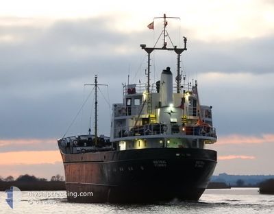
MISTRAL
General Cargo
Current Trip
| Time Travelled | 1 day |
|---|---|
| Remaining Time | 8 h, 10 mins |
| Distance Travelled | 254.03 nm |
| Remaining Distance | 68.57 nm |
| AVG Speed | 8.1 Noeuds |
| MAX Speed | 8.6 Noeuds |
| AVG Wind | 8.2 knots |
| MAX Wind | 12.9 knots |
| MIN Temp | 12.4°C / 54.32°F |
| MAX Temp | 18.1°C / 64.58°F |
| Tirant d eau | 4.5 m |
| Position reçue | Maintenant |
Current Position
| Longitude | 12.30477° |
|---|---|
| Latitude | 54.53647° |
| Etat | Under way using engine |
| Vitesse | 7.8 Noeuds |
| Parcours | 263° |
| Zone | Baltic Sea |
| Station | T-AIS |
| Position reçue | Maintenant |
Info
Information
The current position of MISTRAL is in Baltic Sea with coordinates 54.53647° / 12.30477° as reported on 2024-06-01 22:22 by AIS to our vessel tracker app. The vessel's current speed is 7.8 Noeuds and is heading at the port of LUBECK. The estimated time of arrival as calculated by MyShipTracking vessel tracking app is 2024-06-02 06:33 LT
The vessel MISTRAL (IMO: 6617855, MMSI: 304010366) is a General Cargo that was built in 1966 ( 58 Age ). It's sailing under the flag of [AG] Antigua Barbuda.
In this page you can find informations about the vessels current position, last detected port calls, and current voyage information. If the vessels is not in coverage by AIS you will find the latest position.
The current position of MISTRAL is detected by our AIS receivers and we are not responsible for the reliability of the data. The last position was recorded while the vessel was in Coverage by the Ais receivers of our vessel tracking app.
The current draught of MISTRAL as reported by AIS is 4.5 meters
Weather
| Temperature | 16.3°C / 61.34°F |
|---|---|
| Wind Speed | 10 knots |
| Direction | 335° NNW |
| Pressure | 1013.2 hPa |
| Humidity | 87.5 % |
| Cloud Coverage | 99 % |
Featured Company
Last Port Calls
| Port | Arrival | Departure | Time In Port |
|---|---|---|---|
| 2024-05-29 15:52 | 2024-05-31 15:46 | 1 d | |
| 2024-05-16 12:47 | 2024-05-17 15:26 | 1 d | |
| 2024-05-16 07:57 | 2024-05-16 08:43 | 46 m | |
| 2024-05-13 03:03 | 2024-05-14 18:10 | 1 d | |
| 2024-05-09 06:37 | 2024-05-10 18:31 | 1 d | |
| 2024-05-05 18:45 | 2024-05-07 10:14 | 1 d | |
| 2024-05-02 21:39 | 2024-05-02 21:41 | 1 m | |
| 2024-04-30 19:15 | 2024-05-02 18:02 | 1 d | |
| 2024-04-26 03:54 | 2024-04-29 15:44 | 3 d | |
| 2024-04-20 17:12 | 2024-04-25 09:00 | 4 d |
Last Trips
| Origin | Departure | Destination | Arrival | Distance | |
|---|---|---|---|---|---|
| 2024-05-17 17:26 | 2024-05-29 17:52 | 448.99 nm | |||
| 2024-05-16 10:43 | 2024-05-16 14:47 | 17.88 nm | |||
| 2024-05-14 20:10 | 2024-05-16 09:57 | 344.55 nm | |||
| 2024-05-10 20:31 | 2024-05-13 05:03 | 361.86 nm | |||
| 2024-05-07 12:14 | 2024-05-09 08:37 | 363.16 nm | |||
| 2024-05-02 23:41 | 2024-05-05 20:45 | 342.31 nm | |||
| 2024-05-02 20:02 | 2024-05-02 23:39 | 18.18 nm | |||
| 2024-04-29 17:44 | 2024-04-30 21:15 | 192.77 nm | |||
| 2024-04-25 11:00 | 2024-04-26 05:54 | 154.73 nm | |||
| 2024-04-19 07:00 | 2024-04-20 19:12 | 326.25 nm |
Events
| Heure | Evenement | Détails | Position/ Destination | Info |
|---|---|---|---|---|
| 2024-06-01 18:13 | Etat Changé | Under way using engine Default |
54.68895 / 13.25315
DELBC
|
Vitesse: 8.3 kn Parcours: 252° |
| 2024-06-01 18:10 | Etat Changé | Default Under way using engine |
54.69130 / 13.26525
DELBC
|
Vitesse: 8.3 kn Parcours: 254.5° |
| 2024-06-01 18:06 | Etat Changé | Under way using engine Default |
54.69452 / 13.28312
DELBC
|
Vitesse: 8.3 kn Parcours: 253° |
| 2024-06-01 18:02 | Etat Changé | Default Under way using engine |
54.69715 / 13.29653
DELBC
|
Vitesse: 8.3 kn Parcours: 249.4° |
| 2024-06-01 13:23 | Detecté en mer | German part of the Baltic Sea |
54.71610 / 14.40405
Baltic Sea
DELBC
|
Vitesse: 8.4 kn Parcours: 261° |
| 2024-06-01 10:16 | Detecté en mer | Danish part of the Kattegat |
54.76818 / 15.16255
Kattegat
DELBC
|
Vitesse: 8.6 kn Parcours: 263° |
| 2024-06-01 06:25 | Etat Changé | Under way using engine Default |
54.83992 / 16.11288
DELBC
|
Vitesse: 8.6 kn Parcours: 262° |
| 2024-06-01 06:22 | Etat Changé | Default Under way using engine |
54.84068 / 16.12318
DELBC
|
Vitesse: 8.6 kn Parcours: 262.9° |
| 2024-06-01 05:59 | Etat Changé | Under way using engine Default |
54.84712 / 16.21928
DELBC
|
Vitesse: 8.4 kn Parcours: 263° |
| 2024-06-01 05:27 | Etat Changé | Default Under way using engine |
54.85562 / 16.35168
DELBC
|
Vitesse: 8.4 kn Parcours: 263.3° |