
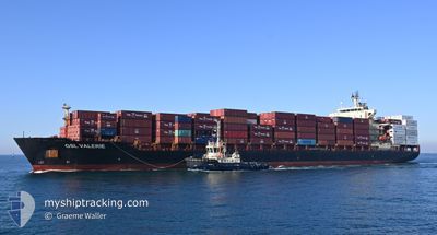
GSL VALERIE
Container Ship
Current Trip
| Trip Time | 7 days |
|---|---|
| Trip Distance | 2722.55 nm |
| AVG Speed | 15 Noeuds |
| MAX Speed | 18.1 Noeuds |
| Tirant d eau | 8.8 m |
| AVG Wind | 9.3 knots |
| MAX Wind | 20.8 knots |
| MIN Temp | 19.8°C / 67.64°F |
| MAX Temp | 30.5°C / 86.9°F |
| Position reçue | 3 d depuis |
Current Position
| Longitude | 118.49935° |
|---|---|
| Latitude | 23.90705° |
| Etat | Under way using engine |
| Vitesse | 17.3 Noeuds |
| Parcours | 48.3° |
| Zone | South China Sea |
| Station | T-AIS |
| Position reçue | 3 d depuis |
Info
Information
The current position of GSL VALERIE is in South China Sea with coordinates 23.90705° / 118.49935° as reported on 2024-06-05 22:33 by AIS to our vessel tracker app. The vessel's current speed is 17.3 Noeuds and is currently inside the port of QINGDAO.
The vessel GSL VALERIE (IMO: 9315874, MMSI: 636018693) is a Container Ship that was built in 2005 ( 19 Age ). It's sailing under the flag of [LR] Liberia.
In this page you can find informations about the vessels current position, last detected port calls, and current voyage information. If the vessels is not in coverage by AIS you will find the latest position.
The current position of GSL VALERIE is detected by our AIS receivers and we are not responsible for the reliability of the data. The last position was recorded while the vessel was in Coverage by the Ais receivers of our vessel tracking app.
The current draught of GSL VALERIE as reported by AIS is 8.8 meters
Weather
| Temperature | 21.8°C / 71.24°F |
|---|---|
| Wind Speed | 12 knots |
| Direction | 201° SSW |
| Pressure | 1005.3 hPa |
| Humidity | 77.6 % |
| Cloud Coverage | 73 % |
Featured Company
Last Port Calls
| Port | Arrival | Departure | Time In Port |
|---|---|---|---|
| 2024-06-09 13:33 | |||
| 2024-05-31 12:58 | 2024-06-01 16:42 | 1 d | |
| 2024-05-04 19:21 | 2024-05-05 18:52 | 23 h | |
| 2024-04-26 16:52 | 2024-04-29 11:28 | 2 d |
Last Trips
| Origin | Departure | Destination | Arrival | Distance | |
|---|---|---|---|---|---|
| 2024-06-01 16:42 | 2024-06-09 13:33 | 2722.55 nm | |||
| 2024-05-05 18:52 | 2024-05-31 12:58 | 8091.84 nm | |||
| 2024-04-29 11:28 | 2024-05-04 19:21 | 364.62 nm | |||
| 2024-04-01 03:16 | 2024-04-26 16:52 | 8242.76 nm |
Events
| Heure | Evenement | Détails | Position/ Destination | Info |
|---|---|---|---|---|
| 2024-06-09 06:29 | Arret |
36.00982 / 120.22706
[CN] QINGDAO
|
Vitesse: 0.2 kn Parcours: 233° |
|
| 2024-06-09 05:33 | Port d'arrivée |
|
36.02267 / 120.35552
[CN] QINGDAO
|
Vitesse: 8.6 kn Parcours: 282° |
| 2024-06-09 02:09 | Démarrage |
35.73789 / 121.04942
MYPKL > CNQIN
|
Vitesse: 7.2 kn Parcours: 272° |
|
| 2024-06-08 12:53 | Arret |
35.73820 / 121.05546
MYPKL > CNQIN
|
Vitesse: 0.3 kn Parcours: 279° |
|
| 2024-06-05 22:33 | Hors de la zone couverte |
23.90705 / 118.49935
South China Sea
MYPKL > CNQIN
|
Vitesse: 17.3 kn Parcours: 48.3° |
|
| 2024-06-05 19:23 | Changement de zone | Chinese part of the South China Sea Malaysian part of the Singapore Strait |
23.34149 / 117.77284
South China Sea
MYPKL > CNQIN
|
Vitesse: 15.5 kn Parcours: 51.1° |
| 2024-06-05 19:21 | Dans la zone couverte |
23.34149 / 117.77284
South China Sea
MYPKL > CNQIN
|
Vitesse: 15.5 kn Parcours: 51.1° |
|
| 2024-06-02 00:34 | Etat Changé | Default Under way using engine |
1.28811 / 104.31274
MYPKL > CNQIN
|
Vitesse: 17.6 kn Parcours: 70.9° |
| 2024-06-02 00:28 | Hors de la zone couverte |
1.27231 / 104.28572
Singapore Strait
MYPKL > CNQIN
|
Vitesse: 17.6 kn Parcours: 70.9° |
|
| 2024-06-02 00:07 | Changement de zone | Malaysian part of the Singapore Strait Indonesian part of the Singapore Strait |
1.25653 / 104.18353
Singapore Strait
MYPKL > CNQIN
|
Vitesse: 17.7 kn Parcours: 81.4° |