
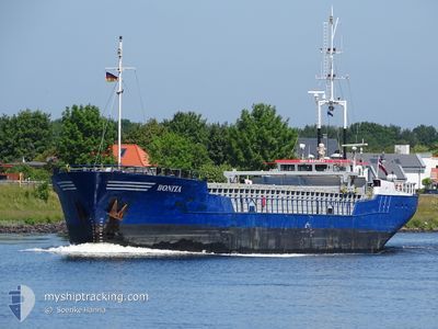
BONITA
General Cargo
Current Trip
| Time Travelled | 3 days |
|---|---|
| Remaining Time | --- |
| Distance Travelled | 372.43 nm |
| Remaining Distance | 11.88 nm |
| AVG Speed | 8.1 Noeuds |
| MAX Speed | 11.1 Noeuds |
| AVG Wind | 11.5 knots |
| MAX Wind | 20 knots |
| MIN Temp | 11.8°C / 53.24°F |
| MAX Temp | 16.3°C / 61.34°F |
| Tirant d eau | 2.2 m |
| Position reçue | 3 m depuis |
Current Position
| Longitude | 9.56086° |
|---|---|
| Latitude | 53.61085° |
| Etat | At anchor |
| Vitesse | 0.1 Noeuds |
| Parcours | 248° |
| Zone | North Sea |
| Station | T-AIS |
| Position reçue | 3 m depuis |
Info
Information
The current position of BONITA is in North Sea with coordinates 53.61085° / 9.56086° as reported on 2024-06-15 08:45 by AIS to our vessel tracker app. The vessel's current speed is 0.1 Noeuds and is heading at the port of HAMBURG. The estimated time of arrival as calculated by MyShipTracking vessel tracking app is 2024-06-15 05:00 LT
The vessel BONITA (IMO: 8609931, MMSI: 275334000) is a General Cargo that was built in 1987 ( 37 Age ). It's sailing under the flag of [LV] Latvia.
In this page you can find informations about the vessels current position, last detected port calls, and current voyage information. If the vessels is not in coverage by AIS you will find the latest position.
The current position of BONITA is detected by our AIS receivers and we are not responsible for the reliability of the data. The last position was recorded while the vessel was in Coverage by the Ais receivers of our vessel tracking app.
The current draught of BONITA as reported by AIS is 2.2 meters
Weather
| Temperature | 13.8°C / 56.84°F |
|---|---|
| Wind Speed | 14 knots |
| Direction | 216° SW |
| Pressure | 1000 hPa |
| Humidity | 93.4 % |
| Cloud Coverage | 100 % |
Featured Company
Last Port Calls
| Port | Arrival | Departure | Time In Port |
|---|---|---|---|
| 2024-06-09 13:53 | 2024-06-11 16:58 | 2 d | |
| 2024-06-05 08:52 | 2024-06-06 21:12 | 1 d | |
| 2024-05-31 06:16 | 2024-06-01 18:41 | 1 d | |
| 2024-05-27 17:31 | 2024-05-28 17:15 | 23 h | |
| 2024-05-23 23:36 | 2024-05-24 16:36 | 16 h | |
| 2024-05-17 07:05 | 2024-05-20 14:03 | 3 d | |
| 2024-05-11 13:56 | 2024-05-13 12:34 | 1 d | |
| 2024-05-11 12:45 | 2024-05-11 13:06 | 21 m | |
| 2024-05-08 15:33 | 2024-05-09 15:57 | 1 d | |
| 2024-05-04 22:09 | 2024-05-06 10:16 | 1 d |
Last Trips
| Origin | Departure | Destination | Arrival | Distance | |
|---|---|---|---|---|---|
| 2024-06-06 21:12 | 2024-06-09 13:53 | 530.52 nm | |||
| 2024-06-01 18:41 | 2024-06-05 08:52 | 531.84 nm | |||
| 2024-05-28 17:15 | 2024-05-31 06:16 | 529.59 nm | |||
| 2024-05-24 16:36 | 2024-05-27 17:31 | 530.47 nm | |||
| 2024-05-20 14:03 | 2024-05-23 23:36 | 616.23 nm | |||
| 2024-05-13 12:34 | 2024-05-17 07:05 | 702.17 nm | |||
| 2024-05-11 13:06 | 2024-05-11 13:56 | 6.94 nm | |||
| 2024-05-09 15:57 | 2024-05-11 12:45 | 393.31 nm | |||
| 2024-05-06 10:16 | 2024-05-08 15:33 | 445.21 nm | |||
| 2024-05-02 17:47 | 2024-05-04 22:09 | 457.42 nm |
Events
| Heure | Evenement | Détails | Position/ Destination | Info |
|---|---|---|---|---|
| 2024-06-15 02:36 | Etat Changé | At anchor Under way using engine |
53.61125 / 9.55865
DE HAM
|
Vitesse: 0.6 kn Parcours: 150° |
| 2024-06-15 02:28 | Arret | 1.29 nm, South East of STADERSAND |
53.61093 / 9.55926
DE HAM
|
Vitesse: 0.3 kn Parcours: 130° |
| 2024-06-14 19:38 | Changement d'ETA | 2024/06/15 03:00 2024/06/15 05:00 |
53.92490 / 8.66250
DE HAM
|
Vitesse: 7.5 kn Parcours: 148.2° |
| 2024-06-14 19:16 | Etat Changé | Under way using engine Default |
53.95600 / 8.60660
DE HAM
|
Vitesse: 7.3 kn Parcours: 112° |
| 2024-06-14 19:00 | Dans la zone couverte |
53.95586 / 8.60713
North Sea
DE HAM
|
Vitesse: 7.4 kn Parcours: 113.8° |
|
| 2024-06-14 14:12 | Etat Changé | Default Under way using engine |
53.86341 / 7.30584
DE HAM
|
Vitesse: 10.4 kn Parcours: 75° |
| 2024-06-14 14:08 | Hors de la zone couverte |
53.86076 / 7.28848
North Sea
DE HAM
|
Vitesse: 10.4 kn Parcours: 75° |
|
| 2024-06-14 13:39 | Etat Changé | Under way using engine Default |
53.84477 / 7.14568
DE HAM
|
Vitesse: 10.7 kn Parcours: 78° |
| 2024-06-14 13:27 | Etat Changé | Default Under way using engine |
53.83801 / 7.08382
DE HAM
|
Vitesse: 10.9 kn Parcours: 79.1° |
| 2024-06-14 12:57 | Changement de zone | German part of the North Sea Dutch part of the North Sea |
53.82096 / 6.93716
North Sea
DE HAM
|
Vitesse: 10.6 kn Parcours: 79.6° |