
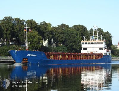
BARENTS
General Cargo
Current Trip
FRSET
| Time Travelled | 1 day |
|---|---|
| Remaining Time | --- |
| Distance Travelled | 58.27 nm |
| Remaining Distance | --- |
| AVG Speed | 9.7 Noeuds |
| MAX Speed | 10 Noeuds |
| AVG Wind | 18.9 knots |
| MAX Wind | 23 knots |
| MIN Temp | 16.8°C / 62.24°F |
| MAX Temp | 20.6°C / 69.08°F |
| Tirant d eau | 3.8 m |
| Position reçue | 7 h, 31 m depuis |
Current Position
| Longitude | 3.94083° |
|---|---|
| Latitude | 42.63609° |
| Etat | Under way using engine |
| Vitesse | 0.7 Noeuds |
| Parcours | 235° |
| Zone | Mediterranean Sea - Western Basin |
| Station | T-AIS |
| Position reçue | 7 h, 31 m depuis |
Info
Information
The current position of BARENTS is in Mediterranean Sea - Western Basin with coordinates 42.63609° / 3.94083° as reported on 2024-05-28 15:58 by AIS to our vessel tracker app. The vessel's current speed is 0.7 Noeuds
The vessel BARENTS (IMO: 9356866, MMSI: 305059000) is a General Cargo that was built in 2007 ( 17 Age ). It's sailing under the flag of [AG] Antigua Barbuda.
In this page you can find informations about the vessels current position, last detected port calls, and current voyage information. If the vessels is not in coverage by AIS you will find the latest position.
The current position of BARENTS is detected by our AIS receivers and we are not responsible for the reliability of the data. The last position was recorded while the vessel was in Coverage by the Ais receivers of our vessel tracking app.
The current draught of BARENTS as reported by AIS is 3.8 meters
Weather
| Temperature | 19.1°C / 66.38°F |
|---|---|
| Wind Speed | 19 knots |
| Direction | 315° NW |
| Pressure | 1017.4 hPa |
| Humidity | 75.5 % |
| Cloud Coverage | 100 % |
Featured Company
Last Port Calls
| Port | Arrival | Departure | Time In Port |
|---|---|---|---|
| 2024-05-26 06:03 | 2024-05-27 12:19 | 1 d | |
| 2024-05-17 13:34 | 2024-05-21 05:58 | 3 d | |
| 2024-05-16 04:44 | 2024-05-16 15:34 | 10 h | |
| 2024-05-08 19:02 | 2024-05-08 21:20 | 2 h | |
| 2024-04-30 10:08 | 2024-05-02 14:28 | 2 d | |
| 2024-04-25 07:16 | 2024-04-28 14:07 | 3 d | |
| 2024-04-18 10:12 | 2024-04-21 13:58 | 3 d | |
| 2024-04-16 16:14 | 2024-04-16 16:24 | 9 m | |
| 2024-04-15 03:17 | 2024-04-16 14:28 | 1 d | |
| 2024-04-12 07:54 | 2024-04-12 20:30 | 12 h |
Most Visited Ports (Last year)
| Port | Arrivals | |
|---|---|---|
| 6 | ||
| 5 | ||
| 3 | ||
| 3 | ||
| 3 | ||
| 2 |
Last Trips
| Origin | Departure | Destination | Arrival | Distance | |
|---|---|---|---|---|---|
| 2024-05-21 07:58 | 2024-05-26 08:03 | 1111.28 nm | |||
| 2024-05-16 17:34 | 2024-05-17 15:34 | 173.70 nm | |||
| 2024-05-08 23:20 | 2024-05-16 06:44 | 1660.69 nm | |||
| 2024-05-02 16:28 | 2024-05-08 21:02 | 1344.19 nm | |||
| 2024-04-28 16:07 | 2024-04-30 12:08 | 409.64 nm | |||
| 2024-04-21 14:58 | 2024-04-25 09:16 | 424.73 nm | |||
| 2024-04-16 18:24 | 2024-04-18 11:12 | 280.63 nm | |||
| 2024-04-16 16:28 | 2024-04-16 18:14 | 10.74 nm | |||
| 2024-04-12 21:30 | 2024-04-15 05:17 | 218.04 nm | |||
| 2024-04-11 20:02 | 2024-04-12 08:54 | 103.08 nm |
Events
| Heure | Evenement | Détails | Position/ Destination | Info |
|---|---|---|---|---|
| 2024-05-28 15:58 | Hors de la zone couverte |
42.63609 / 3.94083
Mediterranean Sea - Western Basin
|
Vitesse: 0.7 kn Parcours: 182.7° |
|
| 2024-05-28 15:58 | Etat Changé | Under way using engine Default |
42.63609 / 3.94083
FRSET
|
Vitesse: Parcours: -1° |
| 2024-05-28 15:13 | Etat Changé | Default Under way using engine |
42.64333 / 3.93833
FRSET
|
Vitesse: 0.7 kn Parcours: 229° |
| 2024-05-28 14:55 | Etat Changé | Under way using engine Default |
42.64871 / 3.93960
FRSET
|
Vitesse: Parcours: -1° |
| 2024-05-28 14:55 | Dans la zone couverte |
42.64871 / 3.93960
Mediterranean Sea - Western Basin
|
Vitesse: 0.8 kn Parcours: 173.7° |
|
| 2024-05-28 14:01 | Etat Changé | Default Under way using engine |
42.66000 / 3.93667
FRSET
|
Vitesse: 0.7 kn Parcours: 229° |
| 2024-05-28 13:49 | Hors de la zone couverte |
42.66326 / 3.93699
Mediterranean Sea - Western Basin
|
Vitesse: 0.7 kn Parcours: 181.9° |
|
| 2024-05-28 13:45 | Etat Changé | Under way using engine Default |
42.66400 / 3.93705
FRSET
|
Vitesse: Parcours: -1° |
| 2024-05-28 13:31 | Etat Changé | Default Under way using engine |
42.66667 / 3.93667
FRSET
|
Vitesse: 0.7 kn Parcours: 230° |
| 2024-05-28 13:20 | Detecté en mer | Spanish part of the Mediterranean Sea - Western Basin |
42.66900 / 3.93771
Mediterranean Sea - Western Basin
|
Vitesse: 0.7 kn Parcours: 177.8° |