
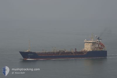
BALVENIE
Oil/Chemical Tanker
Current Trip
| Time Travelled | 547 days |
|---|---|
| Remaining Time | --- |
| Distance Travelled | 1014.45 nm |
| Remaining Distance | --- |
| AVG Speed | 7.3 Noeuds |
| MAX Speed | 17.1 Noeuds |
| AVG Wind | 9.1 knots |
| MAX Wind | 18.6 knots |
| MIN Temp | 26°C / 78.8°F |
| MAX Temp | 29.1°C / 84.38°F |
| Tirant d eau | 5.5 m |
| Position reçue | 2022-11-17 22:29 |
Current Position
| Longitude | -5.35739° |
|---|---|
| Latitude | 36.02660° |
| Etat | Under way using engine |
| Vitesse | 6.9 Noeuds |
| Parcours | 262.2° |
| Zone | Strait of Gibraltar |
| Station | T-AIS |
| Position reçue | 2022-11-17 22:29 |
Info
Information
The current position of BALVENIE is in Strait of Gibraltar with coordinates 36.02660° / -5.35739° as reported on 2022-11-17 22:29 by AIS to our vessel tracker app. The vessel's current speed is 6.9 Noeuds
The vessel BALVENIE (IMO: 9130808, MMSI: 352001207) is a Oil/Chemical Tanker that was built in 1997 ( 27 Age ). It's sailing under the flag of [PA] Panama.
In this page you can find informations about the vessels current position, last detected port calls, and current voyage information. If the vessels is not in coverage by AIS you will find the latest position.
The current position of BALVENIE is detected by our AIS receivers and we are not responsible for the reliability of the data. The last position was recorded while the vessel was in Coverage by the Ais receivers of our vessel tracking app.
The current draught of BALVENIE as reported by AIS is 5.5 meters
Weather
| Temperature | 28.2°C / 82.76°F |
|---|---|
| Wind Speed | 12 knots |
| Direction | 220° SW |
| Pressure | 1012.7 hPa |
| Humidity | 80.7 % |
| Cloud Coverage | 82 % |
Featured Company
Last Port Calls
Most Visited Ports (Last year)
| Port | Arrivals |
|---|
Last Trips
| Origin | Departure | Destination | Arrival | Distance |
|---|
Events
| Heure | Evenement | Détails | Position/ Destination | Info |
|---|---|---|---|---|
| 2024-06-01 22:42 | Arret | 4.6 nm, South of LOME |
6.06101 / 1.29648
LOME
|
Vitesse: Parcours: 199° |
| 2024-06-01 21:22 | Démarrage | 9.47 nm, South of LOME |
5.98011 / 1.26781
LOME
|
Vitesse: 3.7 kn Parcours: 256° |
| 2024-06-01 11:22 | Arret | 9.31 nm, South of LOME |
5.98253 / 1.26959
LOME
|
Vitesse: 0.3 kn Parcours: 189° |
| 2024-06-01 10:26 | Démarrage | 6.99 nm, South of LOME |
6.02500 / 1.25452
LOME
|
Vitesse: 6.1 kn Parcours: 157° |
| 2024-06-01 05:50 | Arret | 6.65 nm, South of LOME |
6.03172 / 1.25215
LOME
|
Vitesse: 0.3 kn Parcours: 243° |
| 2024-05-31 21:18 | Démarrage | 5.91 nm, South of LOME |
6.04596 / 1.32457
LOME
|
Vitesse: 4.5 kn Parcours: 264° |
| 2024-05-31 15:48 | Arret | 6 nm, South East of LOME |
6.04611 / 1.32857
LOME
|
Vitesse: 0.2 kn Parcours: 217° |
| 2024-05-30 22:44 | Arret | 6.57 nm, South East of LOME |
6.04233 / 1.34230
LOME
|
Vitesse: 0.3 kn Parcours: 254° |
| 2024-05-30 21:33 | Démarrage | 5.77 nm, South of LOME |
6.04541 / 1.25754
LOME
|
Vitesse: 4.5 kn Parcours: 90° |
| 2024-05-30 18:24 | Arret | 5.85 nm, South of LOME |
6.04467 / 1.25584
LOME
|
Vitesse: Parcours: 228° |