
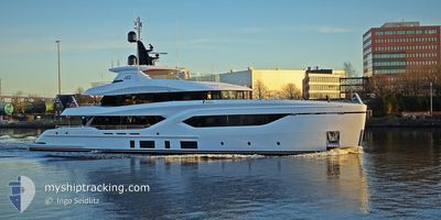
ACE
Pleasure Craft
Current Trip
| Time Travelled | 1 day |
|---|---|
| Remaining Time | 37 mins |
| Distance Travelled | 116.62 nm |
| Remaining Distance | 8.65 nm |
| AVG Speed | 8.8 Noeuds |
| MAX Speed | 10.3 Noeuds |
| AVG Wind | 3.8 knots |
| MAX Wind | 11.4 knots |
| MIN Temp | 17.2°C / 62.96°F |
| MAX Temp | 19.6°C / 67.28°F |
| Tirant d eau | 2.5 m |
| Position reçue | Maintenant |
Current Position
| Longitude | 7.47050° |
|---|---|
| Latitude | 43.71157° |
| Etat | Under way using engine |
| Vitesse | 8.5 Noeuds |
| Parcours | 263.1° |
| Zone | Mediterranean Sea - Western Basin |
| Station | T-AIS |
| Position reçue | Maintenant |
Info
Information
The current position of ACE is in Mediterranean Sea - Western Basin with coordinates 43.71157° / 7.47050° as reported on 2024-05-20 05:28 by AIS to our vessel tracker app. The vessel's current speed is 8.5 Noeuds and is heading at the port of SAINTJEAN CAP FERRAT. The estimated time of arrival as calculated by MyShipTracking vessel tracking app is 2024-05-20 08:06 LT
The vessel ACE (IMO: 9912842, MMSI: 319242700) is a Pleasure Craft It's sailing under the flag of [KY] Cayman Is.
In this page you can find informations about the vessels current position, last detected port calls, and current voyage information. If the vessels is not in coverage by AIS you will find the latest position.
The current position of ACE is detected by our AIS receivers and we are not responsible for the reliability of the data. The last position was recorded while the vessel was in Coverage by the Ais receivers of our vessel tracking app.
The current draught of ACE as reported by AIS is 2.5 meters
Weather
| Temperature | 17.7°C / 63.86°F |
|---|---|
| Wind Speed | 4 knots |
| Direction | 359° N |
| Pressure | 1009.4 hPa |
| Humidity | 59.4 % |
| Cloud Coverage | 93 % |
Featured Company
Last Port Calls
| Port | Arrival | Departure | Time In Port |
|---|---|---|---|
| 2024-05-17 18:01 | 2024-05-18 13:57 | 19 h | |
| 2024-05-10 18:42 | 2024-05-12 12:42 | 1 d | |
| 2024-05-09 19:18 | |||
| 2024-05-08 16:28 | 2024-05-09 11:21 | 18 h | |
| 2024-05-07 10:46 | 2024-05-08 13:19 | 1 d | |
| 2024-04-15 09:39 | 2024-05-04 14:21 | 19 d | |
| 2024-04-08 13:53 | 2024-04-14 12:28 | 5 d | |
| 2024-04-05 18:20 | 2024-04-08 03:19 | 2 d | |
| 2024-04-03 17:29 | 2024-04-04 13:36 | 20 h | |
| 2024-03-23 15:18 | 2024-04-03 12:15 | 10 d |
Most Visited Ports (Last year)
| Port | Arrivals | |
|---|---|---|
| 11 | ||
| 7 | ||
| 5 | ||
| 5 | ||
| 2 | ||
| 2 |
Last Trips
| Origin | Departure | Destination | Arrival | Distance | |
|---|---|---|---|---|---|
| 2024-05-12 12:42 | 2024-05-17 18:01 | 179.85 nm | |||
| 2024-05-09 11:21 | 2024-05-10 18:42 | 77.54 nm | |||
| 2024-05-09 11:21 | 2024-05-09 19:18 | 59.53 nm | |||
| 2024-05-08 13:19 | 2024-05-08 16:28 | 27.43 nm | |||
| 2024-05-04 14:21 | 2024-05-07 10:46 | 13.69 nm | |||
| 2024-04-14 12:28 | 2024-04-15 09:39 | 26.52 nm | |||
| 2024-04-08 03:19 | 2024-04-08 13:53 | 61.64 nm | |||
| 2024-04-04 13:36 | 2024-04-05 18:20 | 43.31 nm | |||
| 2024-04-03 12:15 | 2024-04-03 17:29 | 10.49 nm | |||
| 2024-03-22 12:02 | 2024-03-23 15:18 | 272.25 nm |
Events
| Heure | Evenement | Détails | Position/ Destination | Info |
|---|---|---|---|---|
| 2024-05-20 05:05 | Detecté en mer | French part of the Mediterranean Sea - Western Basin |
43.72093 / 7.55149
Mediterranean Sea - Western Basin
CAP FERRAT
|
Vitesse: 9.2 kn Parcours: 260.1° |
| 2024-05-20 04:37 | Changement de zone | Italian part of the Mediterranean Sea - Western Basin Italian part of the Ligurian Sea |
43.73282 / 7.64967
Mediterranean Sea - Western Basin
CAP FERRAT
|
Vitesse: 9.3 kn Parcours: 259.7° |
| 2024-05-20 02:04 | Dans la zone couverte |
43.85856 / 8.18727
Ligurian Sea
CAP FERRAT
|
Vitesse: 10.3 kn Parcours: 242.6° |
|
| 2024-05-20 00:13 | Hors de la zone couverte |
44.01736 / 8.56121
Ligurian Sea
CAP FERRAT
|
Vitesse: 9.7 kn Parcours: 239.4° |
|
| 2024-05-19 20:36 | Démarrage | 4.86 nm, South East of RECCO |
44.30632 / 9.22586
CAP FERRAT
|
Vitesse: 7.1 kn Parcours: 163.7° |
| 2024-05-19 20:03 | Etat Changé | Under way using engine At anchor |
44.31532 / 9.21781
CAP FERRAT
|
Vitesse: Parcours: 18° |
| 2024-05-19 19:49 | Changement de destination | CAP FERRAT PORTOFINO |
44.31532 / 9.21781
CAP FERRAT
|
Vitesse: Parcours: 18° |
| 2024-05-19 19:49 | Changement d'ETA | 2024/05/20 11:00 2024/05/18 18:00 |
44.31532 / 9.21781
CAP FERRAT
|
Vitesse: Parcours: 18° |
| 2024-05-19 17:59 | Dans la zone couverte |
44.31534 / 9.21785
Ligurian Sea
|
Vitesse: Parcours: 186.2° |
|
| 2024-05-19 16:47 | Hors de la zone couverte |
44.31541 / 9.21779
Ligurian Sea
|
Vitesse: Parcours: 285.5° |