
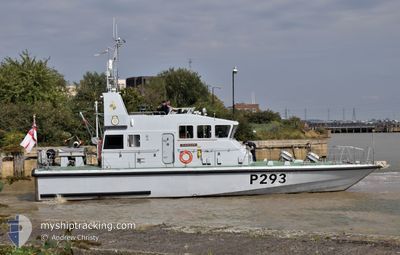
HMS RANGER
Military ops
Current Trip
Unknown
| Time Travelled | --- |
|---|---|
| Remaining Time | --- |
| Distance Travelled | --- |
| Remaining Distance | --- |
| AVG Speed | --- |
| MAX Speed | --- |
| AVG Wind | --- |
| MAX Wind | --- |
| MIN Temp | --- |
| MAX Temp | --- |
| Dybgang | 0 m |
| Position Modtaget | 2 d siden |
Current Position
| Longitude | 15.60857° |
|---|---|
| Latitude | 56.15261° |
| Status | Default |
| Fart | 6 Knots |
| Kurs | 336.5° |
| Område | Baltic Sea |
| Station | T-AIS |
| Position Modtaget | 2 d siden |
Info
Information
The current position of HMS RANGER is in Baltic Sea with coordinates 56.15261° / 15.60857° as reported on 2024-06-15 12:51 by AIS to our vessel tracker app. The vessel's current speed is 6 Knots
The vessel HMS RANGER (MMSI: 232696000) is a Military ops It's sailing under the flag of [GB] United Kingdom.
In this page you can find informations about the vessels current position, last detected port calls, and current voyage information. If the vessels is not in coverage by AIS you will find the latest position.
The current position of HMS RANGER is detected by our AIS receivers and we are not responsible for the reliability of the data. The last position was recorded while the vessel was in Coverage by the Ais receivers of our vessel tracking app.
Weather
| Temperature | 17.9°C / 64.22°F |
|---|---|
| Wind Speed | 15 knots |
| Direction | 121° ESE |
| Pressure | 1006.9 hPa |
| Humidity | 59.7 % |
| Cloud Coverage | 100 % |
Featured Company
Last Port Calls
| Port | Arrival | Departure | Time In Port |
|---|---|---|---|
| 2024-05-22 08:56 | |||
| 2024-05-17 16:12 | |||
| 2024-05-08 09:20 | 2024-05-09 15:16 | 1 d | |
| 2024-05-08 08:16 | 2024-05-08 09:12 | 56 m | |
| 2024-05-08 08:13 | |||
| 2024-05-01 11:03 | 2024-05-03 14:15 | 2 d | |
| 2024-04-29 16:28 | |||
| 2024-04-29 11:38 | 2024-04-29 13:25 | 1 h | |
| 2024-04-25 09:39 | 2024-04-29 11:02 | 4 d | |
| 2024-04-24 15:34 | 2024-04-25 09:03 | 17 h |
Last Trips
| Origin | Departure | Destination | Arrival | Distance | |
|---|---|---|---|---|---|
| 2024-05-09 15:16 | 2024-05-17 16:12 | 244.95 nm | |||
| 2024-05-08 09:12 | 2024-05-08 09:20 | 0.48 nm | |||
| 2024-05-08 08:13 | 2024-05-08 08:16 | 0.23 nm | |||
| 2024-04-29 13:25 | 2024-04-29 16:28 | 53.88 nm | |||
| 2024-04-29 11:02 | 2024-04-29 11:38 | 9.14 nm | |||
| 2024-04-25 09:03 | 2024-04-25 09:39 | 1.96 nm | |||
| 2024-04-24 09:02 | 2024-04-24 15:34 | 24.93 nm | |||
| 2024-04-15 10:56 | 2024-04-23 15:43 | 62.34 nm | |||
| 2024-04-15 10:56 | 2024-04-15 12:06 | 15.40 nm |
Events
| Tid | Hændelsen | Detaljer | Position / Dest | Info |
|---|---|---|---|---|
| 2024-06-15 12:51 | Udenfor Dækning |
56.15261 / 15.60857
Baltic Sea
|
Fart: 6 kn Kurs: 336.5° |
|
| 2024-06-15 12:51 | Indenfor Dækning |
56.15261 / 15.60857
Baltic Sea
|
Fart: 6 kn Kurs: 336.5° |
|
| 2024-06-13 11:49 | Udenfor Dækning |
58.76169 / 18.09420
Baltic Sea
|
Fart: 18.5 kn Kurs: 170.4° |
|
| 2024-06-13 11:16 | Indenfor Dækning |
58.91707 / 18.05869
Baltic Sea
|
Fart: 17.7 kn Kurs: 194.7° |
|
| 2024-06-11 11:26 | Udenfor Dækning |
58.93783 / 18.14853
Baltic Sea
|
Fart: 18.3 kn Kurs: 20.1° |
|
| 2024-06-11 10:52 | Ændre havområde | Swedish part of the Baltic Sea Danish part of the Kattegat |
58.78770 / 18.10854
Baltic Sea
|
Fart: 19.1 kn Kurs: 329.4° |
| 2024-06-11 10:50 | Indenfor Dækning |
58.78770 / 18.10854
Baltic Sea
|
Fart: 19.1 kn Kurs: 329.4° |