
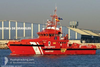
GUARDAMAR POLIMNIA
Salvage/Rescue Vessel
Current Trip
| Trip Time | 5 h, 4 mins |
|---|---|
| Trip Distance | 45.42 nm |
| AVG Speed | 9.8 Knots |
| MAX Speed | 10.5 Knots |
| Dybgang | 2.4 m |
| AVG Wind | 13.9 knots |
| MAX Wind | 14 knots |
| MIN Temp | 20.6°C / 69.08°F |
| MAX Temp | 31.6°C / 88.88°F |
| Position Modtaget | 2 m siden |
Current Position
| Longitude | -6.28112° |
|---|---|
| Latitude | 36.53366° |
| Status | Moored |
| Fart | |
| Kurs | 226° |
| Område | North Atlantic Ocean |
| Station | T-AIS |
| Position Modtaget | 2 m siden |
Info
Information
The current position of GUARDAMAR POLIMNIA is in North Atlantic Ocean with coordinates 36.53366° / -6.28112° as reported on 2024-06-17 02:30 by AIS to our vessel tracker app. The vessel's current speed is 0 Knots and is currently inside the port of CADIZ.
The vessel GUARDAMAR POLIMNIA (IMO: 9541679, MMSI: 224179000) is a Salvage/Rescue Vessel that was built in 2009 ( 15 år gamle ). It's sailing under the flag of [ES] Spain.
In this page you can find informations about the vessels current position, last detected port calls, and current voyage information. If the vessels is not in coverage by AIS you will find the latest position.
The current position of GUARDAMAR POLIMNIA is detected by our AIS receivers and we are not responsible for the reliability of the data. The last position was recorded while the vessel was in Coverage by the Ais receivers of our vessel tracking app.
The current draught of GUARDAMAR POLIMNIA as reported by AIS is 2.4 meters
Weather
| Temperature | 19.3°C / 66.74°F |
|---|---|
| Wind Speed | 5 knots |
| Direction | 149° SSE |
| Pressure | 1013 hPa |
| Humidity | 88.7 % |
| Cloud Coverage | --- |
Featured Company
Last Port Calls
| Port | Arrival | Departure | Time In Port |
|---|---|---|---|
| 2024-06-14 23:53 | |||
| 2024-06-14 14:22 | 2024-06-14 18:49 | 4 h | |
| 2024-06-13 20:47 | 2024-06-14 11:19 | 14 h | |
| 2024-06-12 20:50 | 2024-06-13 08:30 | 11 h | |
| 2024-06-12 10:12 | 2024-06-12 17:31 | 7 h | |
| 2024-06-09 14:04 | 2024-06-11 18:09 | 2 d | |
| 2024-06-09 08:23 | 2024-06-09 09:39 | 1 h | |
| 2024-06-03 12:58 | 2024-06-07 19:56 | 4 d | |
| 2024-05-23 13:13 | 2024-05-28 07:23 | 4 d | |
| 2024-05-18 12:53 | 2024-05-23 12:38 | 4 d |
Last Trips
| Origin | Departure | Destination | Arrival | Distance | |
|---|---|---|---|---|---|
| 2024-06-14 18:49 | 2024-06-14 23:53 | 45.42 nm | |||
| 2024-06-14 11:19 | 2024-06-14 14:22 | 3.43 nm | |||
| 2024-06-13 08:30 | 2024-06-13 20:47 | 15.63 nm | |||
| 2024-06-12 17:31 | 2024-06-12 20:50 | 17.66 nm | |||
| 2024-06-11 18:09 | 2024-06-12 10:12 | 59.01 nm | |||
| 2024-06-09 09:39 | 2024-06-09 14:04 | 64.50 nm | |||
| 2024-06-07 19:56 | 2024-06-09 08:23 | 508.42 nm | |||
| 2024-05-28 07:23 | 2024-06-03 12:58 | 111.55 nm | |||
| 2024-05-23 12:38 | 2024-05-23 13:13 | 6.39 nm | |||
| 2024-05-18 07:51 | 2024-05-18 12:53 | 54.94 nm |
Events
| Tid | Hændelsen | Detaljer | Position / Dest | Info |
|---|---|---|---|---|
| 2024-06-14 23:48 | Indenfor Dækning |
36.53371 / -6.28115
North Atlantic Ocean
[ES] CADIZ
|
Fart: Kurs: 309.1° |
|
| 2024-06-14 21:53 | Skibe i havn |
|
36.53371 / -6.28115
[ES] CADIZ
|
Fart: 9.8 kn Kurs: 214.1° |
| 2024-06-14 17:43 | Udenfor Dækning |
37.19659 / -6.09601
North Atlantic Ocean
|
Fart: 9.8 kn Kurs: 214.1° |
|
| 2024-06-14 17:15 | START Sejllads | 1.14 nm, South West of CORIA DEL RIO |
37.26586 / -6.05787
SEARCH AND RESCUE
|
Fart: 9.6 kn Kurs: 202° |
| 2024-06-14 16:49 | Afsejlet fra sidste havn |
|
37.26586 / -6.05787
SEARCH AND RESCUE
|
Fart: 0.1 kn Kurs: 250° |
| 2024-06-14 16:22 | STOP Sejllads |
37.32057 / -6.00193
[ES] SEVILLA
|
Fart: 0.1 kn Kurs: 250° |
|
| 2024-06-14 16:06 | Indenfor Dækning |
37.32980 / -5.99364
North Atlantic Ocean
[ES] SEVILLA
|
Fart: 5.5 kn Kurs: 223.9° |
|
| 2024-06-14 13:01 | Udenfor Dækning |
37.32876 / -5.99362
North Atlantic Ocean
[ES] SEVILLA
|
Fart: 4.7 kn Kurs: 37.9° |
|
| 2024-06-14 12:51 | START Sejllads |
37.31987 / -6.00340
[ES] SEVILLA
|
Fart: 3.4 kn Kurs: 63° |
|
| 2024-06-14 12:35 | STOP Sejllads |
37.31882 / -6.00631
[ES] SEVILLA
|
Fart: 0.3 kn Kurs: 64° |