
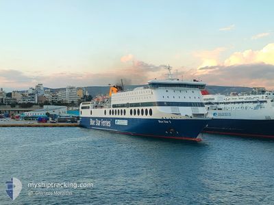
BLUE STAR 2
Ro-Ro/Passenger Ship
Current Trip
| Time Travelled | 1 h, 37 mins |
|---|---|
| Remaining Time | 8 h, 12 mins |
| Distance Travelled | 38.42 nm |
| Remaining Distance | 212.99 nm |
| AVG Speed | 25.5 Knots |
| MAX Speed | 25.9 Knots |
| AVG Wind | 15 knots |
| MAX Wind | 18.5 knots |
| MIN Temp | 18.2°C / 64.76°F |
| MAX Temp | 18.7°C / 65.66°F |
| Dybgang | 6.3 m |
| Position Modtaget | Nu |
Current Position
| Longitude | 27.42368° |
|---|---|
| Latitude | 36.52237° |
| Status | Under way using engine |
| Fart | 24.9 Knots |
| Kurs | 273.1° |
| Område | Aegean Sea |
| Station | T-AIS |
| Position Modtaget | Nu |
Info
Information
The current position of BLUE STAR 2 is in Aegean Sea with coordinates 36.52237° / 27.42368° as reported on 2024-04-30 08:40 by AIS to our vessel tracker app. The vessel's current speed is 24.9 Knots and is heading at the port of PIRAEUS. The estimated time of arrival as calculated by MyShipTracking vessel tracking app is 2024-04-30 16:53 LT
The vessel BLUE STAR 2 (IMO: 9207584, MMSI: 239737000) is a Ro-Ro/Passenger Ship that was built in 2000 ( 24 år gamle ). It's sailing under the flag of [GR] Greece.
In this page you can find informations about the vessels current position, last detected port calls, and current voyage information. If the vessels is not in coverage by AIS you will find the latest position.
The current position of BLUE STAR 2 is detected by our AIS receivers and we are not responsible for the reliability of the data. The last position was recorded while the vessel was in Coverage by the Ais receivers of our vessel tracking app.
The current draught of BLUE STAR 2 as reported by AIS is 6.3 meters
Weather
| Temperature | 18.1°C / 64.58°F |
|---|---|
| Wind Speed | 15 knots |
| Direction | 312° NW |
| Pressure | 1012.2 hPa |
| Humidity | 77.2 % |
| Cloud Coverage | --- |
Featured Company
Last Port Calls
| Port | Arrival | Departure | Time In Port |
|---|---|---|---|
| 2024-04-30 05:10 | 2024-04-30 07:04 | 1 h | |
| 2024-04-30 01:23 | 2024-04-30 02:38 | 1 h | |
| 2024-04-28 03:43 | 2024-04-29 17:05 | 1 d | |
| 2024-04-27 17:40 | 2024-04-27 18:44 | 1 h | |
| 2024-04-27 06:15 | 2024-04-27 15:11 | 8 h | |
| 2024-04-27 03:01 | 2024-04-27 03:48 | 46 m | |
| 2024-04-26 23:18 | 2024-04-26 23:50 | 32 m | |
| 2024-04-25 22:17 | 2024-04-26 17:42 | 19 h | |
| 2024-04-25 17:43 | 2024-04-25 18:24 | 41 m | |
| 2024-04-25 16:31 | 2024-04-25 17:00 | 29 m |
Last Trips
| Origin | Departure | Destination | Arrival | Distance | |
|---|---|---|---|---|---|
| 2024-04-30 05:38 | 2024-04-30 08:10 | 55.97 nm | |||
| 2024-04-29 20:05 | 2024-04-30 04:23 | 198.30 nm | |||
| 2024-04-27 21:44 | 2024-04-28 06:43 | 195.43 nm | |||
| 2024-04-27 18:11 | 2024-04-27 20:40 | 61.28 nm | |||
| 2024-04-27 06:48 | 2024-04-27 09:15 | 55.30 nm | |||
| 2024-04-27 02:50 | 2024-04-27 06:01 | 76.06 nm | |||
| 2024-04-26 20:42 | 2024-04-27 02:18 | 137.28 nm | |||
| 2024-04-25 21:24 | 2024-04-26 01:17 | 93.54 nm | |||
| 2024-04-25 20:00 | 2024-04-25 20:43 | 16.51 nm | |||
| 2024-04-25 17:37 | 2024-04-25 19:31 | 45.17 nm |
Events
| Tid | Hændelsen | Detaljer | Position / Dest | Info |
|---|---|---|---|---|
| 2024-04-30 07:40 | Ændre havområde | Greek part of the Aegean Sea Turkish part of the Aegean Sea |
36.48928 / 27.94677
Aegean Sea
PI KO RO
|
Fart: 25.8 kn Kurs: 277.5° |
| 2024-04-30 07:31 | Ændre havområde | Turkish part of the Aegean Sea Greek part of the Aegean Sea |
36.48120 / 28.02778
Aegean Sea
PI KO RO
|
Fart: 25.9 kn Kurs: 276.2° |
| 2024-04-30 07:11 | Ændre havområde | Greek part of the Aegean Sea Greek part of the Mediterranean Sea - Eastern Basin |
36.46675 / 28.20063
Aegean Sea
PI KO RO
|
Fart: 23.9 kn Kurs: 276.6° |
| 2024-04-30 07:04 | Afsejlet fra sidste havn |
|
36.45200 / 28.23480
PI KO RO
|
Fart: 10.8 kn Kurs: 349° |
| 2024-04-30 07:04 | START Sejllads |
36.44920 / 28.23522
[GR] RHODES
|
Fart: 6.5 kn Kurs: 342° |
|
| 2024-04-30 05:12 | STOP Sejllads |
36.44738 / 28.23560
[GR] RHODES
|
Fart: 0.3 kn Kurs: 235° |
|
| 2024-04-30 05:10 | Skibe i havn |
|
36.44923 / 28.23585
[GR] RHODES
|
Fart: 10 kn Kurs: 169.6° |
| 2024-04-30 05:08 | Ændre havområde | Greek part of the Mediterranean Sea - Eastern Basin Greek part of the Aegean Sea |
36.45747 / 28.23238
Mediterranean Sea - Eastern Basin
PI KO RO
|
Fart: 12.9 kn Kurs: 154° |
| 2024-04-30 04:43 | Ændre havområde | Greek part of the Aegean Sea Turkish part of the Aegean Sea |
36.48538 / 28.04070
Aegean Sea
PI KO RO
|
Fart: 24.3 kn Kurs: 95.1° |
| 2024-04-30 04:35 | Ændre havområde | Turkish part of the Aegean Sea Greek part of the Aegean Sea |
36.49012 / 27.97445
Aegean Sea
PI KO RO
|
Fart: 24.4 kn Kurs: 95.5° |