
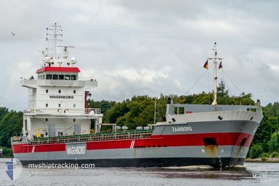
ZAANBORG
General Cargo
Current Trip
| Time Travelled | 2 days |
|---|---|
| Remaining Time | --- |
| Distance Travelled | 539.70 nm |
| Remaining Distance | --- |
| AVG Speed | 11.2 Knots |
| MAX Speed | 13.1 Knots |
| AVG Wind | 11.8 knots |
| MAX Wind | 19.9 knots |
| MIN Temp | -5.7°C / 21.74°F |
| MAX Temp | 1.9°C / 35.42°F |
| Draught | 7.1 m |
| Position Received | 5 h, 40 m ago |
Current Position
| Longitude | 18.57827° |
|---|---|
| Latitude | 58.27590° |
| Status | Under way using engine |
| Speed | 11.2 Knots |
| Course | 210.4° |
| Area | Baltic Sea |
| Station | T-AIS |
| Position Received | 5 h, 40 m ago |
Info
Information
The current position of ZAANBORG is in Baltic Sea with coordinates 58.27590° / 18.57827° as reported on 2024-04-19 03:50 by AIS to our vessel tracker app. The vessel's current speed is 11.2 Knots and is heading at the port of MOERDIJK. The estimated time of arrival as calculated by MyShipTracking vessel tracking app is 2024-04-21 12:00 LT
The vessel ZAANBORG (IMO: 9224154, MMSI: 244830818) is a General Cargo that was built in 2001 ( 23 years old ). It's sailing under the flag of [NL] Netherlands.
In this page you can find informations about the vessels current position, last detected port calls, and current voyage information. If the vessels is not in coverage by AIS you will find the latest position.
The current position of ZAANBORG is detected by our AIS receivers and we are not responsible for the reliability of the data. The last position was recorded while the vessel was in Coverage by the Ais receivers of our vessel tracking app.
The current draught of ZAANBORG as reported by AIS is 7.1 meters
Weather
| Temperature | 1.9°C / 35.42°F |
|---|---|
| Wind Speed | 13 knots |
| Direction | 64° ENE |
| Pressure | 1009.3 hPa |
| Humidity | 76.2 % |
| Cloud Coverage | 100 % |
Featured Company
Last Port Calls
| Port | Arrival | Departure | Time In Port |
|---|---|---|---|
| 2024-04-13 14:38 | 2024-04-16 18:11 | 3 d | |
| 2024-04-05 07:41 | 2024-04-07 01:39 | 1 d | |
| 2024-03-25 13:10 | 2024-03-26 13:00 | 23 h | |
| 2024-03-18 12:31 | 2024-03-22 12:06 | 3 d | |
| 2024-03-12 02:36 | 2024-03-15 06:43 | 3 d | |
| 2024-03-11 21:31 | 2024-03-11 23:58 | 2 h | |
| 2024-03-02 14:41 | 2024-03-08 16:16 | 6 d | |
| 2024-02-15 13:19 | 2024-02-18 10:57 | 2 d | |
| 2024-02-09 11:18 | 2024-02-10 14:35 | 1 d | |
| 2024-02-02 16:15 |
Last Trips
| Origin | Departure | Destination | Arrival | Distance | |
|---|---|---|---|---|---|
| 2024-04-07 03:39 | 2024-04-13 17:38 | 1140.89 nm | |||
| 2024-03-26 14:00 | 2024-04-05 09:41 | 492.43 nm | |||
| 2024-03-22 12:06 | 2024-03-25 14:10 | 861.11 nm | |||
| 2024-03-15 07:43 | 2024-03-18 12:31 | 834.42 nm | |||
| 2024-03-12 00:58 | 2024-03-12 03:36 | 36.44 nm | |||
| 2024-03-08 17:16 | 2024-03-11 22:31 | 894.59 nm | |||
| 2024-02-18 11:57 | 2024-03-02 15:41 | 1301.12 nm | |||
| 2024-02-10 16:35 | 2024-02-15 14:19 | 977.03 nm | |||
| 2024-02-02 17:15 | 2024-02-09 13:18 | 1302.46 nm |
Events
| Time | Event | Details | Position / Dest | Info |
|---|---|---|---|---|
| 2024-04-19 03:50 | OUT of Coverage |
58.27590 / 18.57827
Baltic Sea
NLMOE
|
Speed: 11.2 kn Course: 210.4° |
|
| 2024-04-18 23:37 | IN Coverage |
58.97362 / 19.32783
Baltic Sea
NLMOE
|
Speed: 11.2 kn Course: 208.6° |
|
| 2024-04-18 22:10 | OUT of Coverage |
59.21460 / 19.59347
Baltic Sea
NLMOE
|
Speed: 11.4 kn Course: 211.5° |
|
| 2024-04-18 19:38 | Change Sea Area | Swedish part of the Baltic Sea Finnish part of the Baltic Sea |
59.57737 / 19.95698
Baltic Sea
NLMOE
|
Speed: 10.5 kn Course: 195.4° |
| 2024-04-18 18:16 | Detected in Sea | Finnish part of the Baltic Sea |
59.78756 / 19.66493
Baltic Sea
NLMOE
|
Speed: 11.2 kn Course: 142.7° |
| 2024-04-18 18:10 | Change Sea Area | Swedish part of the Baltic Sea Swedish part of the Gulf of Bothnia |
59.80235 / 19.64173
Baltic Sea
NLMOE
|
Speed: 11.3 kn Course: 142.4° |
| 2024-04-18 13:37 | Detected in Sea | Swedish part of the Gulf of Bothnia |
60.55017 / 19.02554
Gulf of Bothnia
NLMOE
|
Speed: 11.1 kn Course: 193.8° |
| 2024-04-18 13:37 | Status Changed | Under way using engine Default |
60.55017 / 19.02554
NLMOE
|
Speed: 11.2 kn Course: 195° |
| 2024-04-18 13:37 | IN Coverage |
60.55017 / 19.02554
Gulf of Bothnia
NLMOE
|
Speed: 11.1 kn Course: 193.8° |
|
| 2024-04-18 00:08 | OUT of Coverage |
63.00436 / 20.23739
Gulf of Bothnia
NLMOE
|
Speed: 11.3 kn Course: 195.2° |