
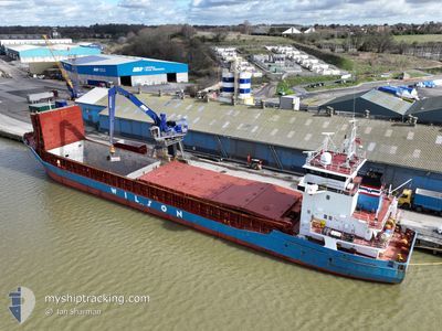
WILSON GDANSK
General Cargo
Current Trip
| Time Travelled | 13 h, 45 mins |
|---|---|
| Remaining Time | 6 h, 30 mins |
| Distance Travelled | 70.24 nm |
| Remaining Distance | 71.77 nm |
| AVG Speed | 8.7 Knots |
| MAX Speed | 11 Knots |
| AVG Wind | 23.7 knots |
| MAX Wind | 25 knots |
| MIN Temp | 9°C / 48.2°F |
| MAX Temp | 10.1°C / 50.18°F |
| Draught | 3.7 m |
| Position Received | 3 m ago |
Current Position
| Longitude | 2.64191° |
|---|---|
| Latitude | 51.42554° |
| Status | At anchor |
| Speed | 0.4 Knots |
| Course | 263° |
| Area | North Sea |
| Station | T-AIS |
| Position Received | 3 m ago |
Info
Information
The current position of WILSON GDANSK is in North Sea with coordinates 51.42554° / 2.64191° as reported on 2024-04-19 09:05 by AIS to our vessel tracker app. The vessel's current speed is 0.4 Knots and is heading at the port of ANTWERP. The estimated time of arrival as calculated by MyShipTracking vessel tracking app is 2024-04-19 15:38 LT
The vessel WILSON GDANSK (IMO: 9056026, MMSI: 314191000) is a General Cargo that was built in 1993 ( 31 years old ). It's sailing under the flag of [BB] Barbados.
In this page you can find informations about the vessels current position, last detected port calls, and current voyage information. If the vessels is not in coverage by AIS you will find the latest position.
The current position of WILSON GDANSK is detected by our AIS receivers and we are not responsible for the reliability of the data. The last position was recorded while the vessel was in Coverage by the Ais receivers of our vessel tracking app.
The current draught of WILSON GDANSK as reported by AIS is 3.7 meters
Weather
| Temperature | 9.9°C / 49.82°F |
|---|---|
| Wind Speed | 24 knots |
| Direction | 299° WNW |
| Pressure | 1011.8 hPa |
| Humidity | 85.3 % |
| Cloud Coverage | 100 % |
Featured Company
Last Port Calls
| Port | Arrival | Departure | Time In Port |
|---|---|---|---|
| 2024-04-14 13:48 | 2024-04-18 19:23 | 4 d | |
| 2024-03-15 05:03 | 2024-03-22 07:12 | 7 d | |
| 2024-02-27 11:48 | 2024-03-01 10:58 | 2 d | |
| 2024-02-21 17:44 | 2024-02-26 19:21 | 5 d | |
| 2024-02-18 21:12 | 2024-02-20 17:48 | 1 d | |
| 2024-02-14 23:16 | 2024-02-15 00:22 | 1 h | |
| 2024-02-14 22:40 | 2024-02-14 22:58 | 17 m | |
| 2024-02-13 05:32 | 2024-02-14 22:00 | 1 d | |
| 2024-02-13 04:30 | 2024-02-13 04:47 | 17 m | |
| 2024-02-13 03:32 | 2024-02-13 04:12 | 39 m |
Last Trips
| Origin | Departure | Destination | Arrival | Distance | |
|---|---|---|---|---|---|
| 2024-03-22 09:12 | 2024-04-14 15:48 | 4553.37 nm | |||
| 2024-03-01 11:58 | 2024-03-15 07:03 | 2811.23 nm | |||
| 2024-02-26 19:21 | 2024-02-27 12:48 | 144.45 nm | |||
| 2024-02-20 17:48 | 2024-02-21 17:44 | 231.24 nm | |||
| 2024-02-15 00:22 | 2024-02-18 21:12 | 739.12 nm | |||
| 2024-02-14 22:58 | 2024-02-14 23:16 | 1.93 nm | |||
| 2024-02-14 22:00 | 2024-02-14 22:40 | 4.55 nm | |||
| 2024-02-13 04:47 | 2024-02-13 05:32 | 4.12 nm | |||
| 2024-02-13 04:12 | 2024-02-13 04:30 | 2.00 nm | |||
| 2024-02-07 21:20 | 2024-02-13 03:32 | 1055.53 nm |
Events
| Time | Event | Details | Position / Dest | Info |
|---|---|---|---|---|
| 2024-04-19 08:50 | Status Changed | At anchor Under way using engine |
51.42539 / 2.64165
WANDELAAR PS
|
Speed: 0.4 kn Course: 273° |
| 2024-04-19 08:17 | STOP Moving | 16.52 nm, North West of OOSTENDE |
51.42558 / 2.64060
WANDELAAR PS
|
Speed: 0.3 kn Course: 278° |
| 2024-04-19 06:28 | Change Sea Area | Belgian part of the North Sea French part of the North Sea |
51.32592 / 2.37082
North Sea
WANDELAAR PS
|
Speed: 8.3 kn Course: 59.4° |
| 2024-04-19 06:01 | IN Coverage |
51.29019 / 2.28797
North Sea
WANDELAAR PS
|
Speed: 8.8 kn Course: 57° |
|
| 2024-04-19 04:36 | OUT of Coverage |
51.18345 / 2.00162
North Sea
WANDELAAR PS
|
Speed: 8.7 kn Course: 62.9° |
|
| 2024-04-19 02:25 | Detected in Sea | French part of the North Sea |
50.99450 / 1.62816
North Sea
WANDELAAR PS
|
Speed: 8.3 kn Course: 41.1° |
| 2024-04-19 00:31 | Draught Changed | 3.7 5.8 |
50.75551 / 1.42921
WANDELAAR PS
|
Speed: 8.4 kn Course: 21° |
| 2024-04-19 00:31 | Destination Changed | WANDELAAR PS FRLTR |
50.75551 / 1.42921
WANDELAAR PS
|
Speed: 8.4 kn Course: 21° |
| 2024-04-19 00:31 | ETA Changed | 2024/04/19 08:00 2024/04/13 22:00 |
50.75551 / 1.42921
WANDELAAR PS
|
Speed: 8.4 kn Course: 21° |
| 2024-04-18 23:52 | IN Coverage |
50.68279 / 1.33784
English Channel
|
Speed: 8.6 kn Course: 40.3° |