
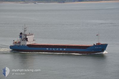
WILSON DOVER
General Cargo
Current Trip
| Time Travelled | 1 day |
|---|---|
| Remaining Time | --- |
| Distance Travelled | 222.68 nm |
| Remaining Distance | --- |
| AVG Speed | 11.5 Knots |
| MAX Speed | 13.8 Knots |
| AVG Wind | 9.5 knots |
| MAX Wind | 13.9 knots |
| MIN Temp | 5°C / 41°F |
| MAX Temp | 10.4°C / 50.72°F |
| Draught | 5.5 m |
| Position Received | 17 h, 54 m ago |
Current Position
| Longitude | -0.41305° |
|---|---|
| Latitude | 49.60489° |
| Status | Under way using engine |
| Speed | 8.7 Knots |
| Course | 299.4° |
| Area | English Channel |
| Station | T-AIS |
| Position Received | 17 h, 54 m ago |
Info
Information
The current position of WILSON DOVER is in English Channel with coordinates 49.60489° / -0.41305° as reported on 2024-04-24 22:01 by AIS to our vessel tracker app. The vessel's current speed is 8.7 Knots and is heading at the port of GIJON. The estimated time of arrival as calculated by MyShipTracking vessel tracking app is 2024-04-27 08:00 LT
The vessel WILSON DOVER (IMO: 9005754, MMSI: 314251000) is a General Cargo that was built in 1993 ( 31 years old ). It's sailing under the flag of [BB] Barbados.
In this page you can find informations about the vessels current position, last detected port calls, and current voyage information. If the vessels is not in coverage by AIS you will find the latest position.
The current position of WILSON DOVER is detected by our AIS receivers and we are not responsible for the reliability of the data. The last position was recorded while the vessel was in Coverage by the Ais receivers of our vessel tracking app.
The current draught of WILSON DOVER as reported by AIS is 5.5 meters
Weather
| Temperature | 10.4°C / 50.72°F |
|---|---|
| Wind Speed | 8 knots |
| Direction | 265° W |
| Pressure | 1006.7 hPa |
| Humidity | 69.6 % |
| Cloud Coverage | 31 % |
Featured Company
Last Port Calls
| Port | Arrival | Departure | Time In Port |
|---|---|---|---|
| 2024-04-22 10:30 | 2024-04-24 14:02 | 2 d | |
| 2024-04-09 23:58 | 2024-04-11 13:56 | 1 d | |
| 2024-04-08 22:40 | |||
| 2024-04-06 03:20 | 2024-04-08 21:18 | 2 d | |
| 2024-04-06 02:09 | 2024-04-06 02:21 | 12 m | |
| 2024-03-31 07:52 | 2024-04-03 22:21 | 3 d | |
| 2024-03-29 07:21 | 2024-03-30 06:28 | 23 h | |
| 2024-03-21 09:00 | 2024-03-22 17:34 | 1 d | |
| 2024-03-18 17:18 | 2024-03-20 19:15 | 2 d | |
| 2024-03-09 22:57 | 2024-03-11 19:13 | 1 d |
Last Trips
| Origin | Departure | Destination | Arrival | Distance | |
|---|---|---|---|---|---|
| 2024-04-11 14:56 | 2024-04-22 12:30 | 1426.07 nm | |||
| 2024-04-08 23:18 | 2024-04-10 00:58 | 200.62 nm | |||
| 2024-04-08 23:18 | 2024-04-09 00:40 | 8.57 nm | |||
| 2024-04-06 04:21 | 2024-04-06 05:20 | 8.14 nm | |||
| 2024-04-04 00:21 | 2024-04-06 04:09 | 470.39 nm | |||
| 2024-03-30 07:28 | 2024-03-31 09:52 | 239.38 nm | |||
| 2024-03-22 17:34 | 2024-03-29 08:21 | 602.02 nm | |||
| 2024-03-20 20:15 | 2024-03-21 09:00 | 133.56 nm | |||
| 2024-03-11 20:13 | 2024-03-18 18:18 | 1342.67 nm | |||
| 2024-03-09 12:11 | 2024-03-09 23:57 | 98.11 nm |
Events
| Time | Event | Details | Position / Dest | Info |
|---|---|---|---|---|
| 2024-04-24 22:01 | Status Changed | Default Under way using engine |
49.60560 / -.41497
ESGIJ
|
Speed: 8.7 kn Course: 299.4° |
| 2024-04-24 22:01 | OUT of Coverage |
49.60489 / -.41305
English Channel
ESGIJ
|
Speed: 8.7 kn Course: 299.4° |
|
| 2024-04-24 18:05 | START Moving | 2.07 nm, South West of RADICATEL |
49.46312 / .44544
ESGIJ
|
Speed: 12.2 kn Course: 236.1° |
| 2024-04-24 18:05 | STOP Moving | 1.95 nm, South West of RADICATEL |
49.46419 / .44803
ESGIJ
|
Speed: Course: 0° |
| 2024-04-24 18:04 | START Moving | 1.86 nm, South West of RADICATEL |
49.46502 / .44992
ESGIJ
|
Speed: 11.9 kn Course: 232.5° |
| 2024-04-24 18:03 | STOP Moving | 1.75 nm, South West of RADICATEL |
49.46623 / .45216
ESGIJ
|
Speed: Course: 0° |
| 2024-04-24 17:54 | START Moving | 0.1 nm, South West of RADICATEL |
49.48376 / .48465
ESGIJ
|
Speed: 11.1 kn Course: 242.2° |
| 2024-04-24 17:54 | STOP Moving | 0.06 nm, South East of RADICATEL |
49.48470 / .48753
ESGIJ
|
Speed: Course: 0° |
| 2024-04-24 17:46 | START Moving | 0.76 nm, North West of PORT JEROME |
49.48111 / .52198
ESGIJ
|
Speed: 11.4 kn Course: 316.3° |
| 2024-04-24 17:46 | STOP Moving | 0.64 nm, North West of PORT JEROME |
49.47962 / .52394
ESGIJ
|
Speed: Course: 0° |