
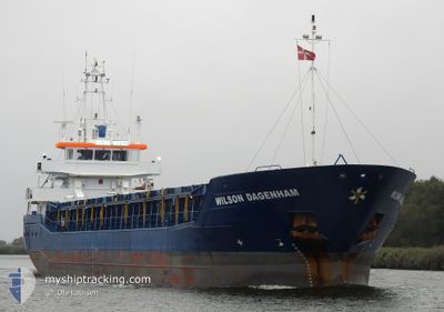
WILSON DAGENHAM
General Cargo
Current Trip
| Time Travelled | 2 days |
|---|---|
| Remaining Time | --- |
| Distance Travelled | 492.46 nm |
| Remaining Distance | --- |
| AVG Speed | 9.9 Knots |
| MAX Speed | 11.3 Knots |
| AVG Wind | 8.5 knots |
| MAX Wind | 24 knots |
| MIN Temp | -6.3°C / 20.66°F |
| MAX Temp | 4.8°C / 40.64°F |
| Draught | 5.2 m |
| Position Received | 1 m ago |
Current Position
| Longitude | 4.37554° |
|---|---|
| Latitude | 60.38616° |
| Status | Under way using engine |
| Speed | 9.8 Knots |
| Course | 172.9° |
| Area | North Sea |
| Station | T-AIS |
| Position Received | 1 m ago |
Info
Information
The current position of WILSON DAGENHAM is in North Sea with coordinates 60.38616° / 4.37554° as reported on 2024-04-25 07:10 by AIS to our vessel tracker app. The vessel's current speed is 9.8 Knots and is heading at the port of LIDKOPING. The estimated time of arrival as calculated by MyShipTracking vessel tracking app is 2024-04-28 07:00 LT
The vessel WILSON DAGENHAM (IMO: 9409613, MMSI: 305810000) is a General Cargo that was built in 2009 ( 15 years old ). It's sailing under the flag of [AG] Antigua Barbuda.
In this page you can find informations about the vessels current position, last detected port calls, and current voyage information. If the vessels is not in coverage by AIS you will find the latest position.
The current position of WILSON DAGENHAM is detected by our AIS receivers and we are not responsible for the reliability of the data. The last position was recorded while the vessel was in Coverage by the Ais receivers of our vessel tracking app.
The current draught of WILSON DAGENHAM as reported by AIS is 5.2 meters
Weather
| Temperature | 4.6°C / 40.28°F |
|---|---|
| Wind Speed | 3 knots |
| Direction | 59° ENE |
| Pressure | 1004.9 hPa |
| Humidity | 68.9 % |
| Cloud Coverage | 100 % |
Featured Company
Last Port Calls
| Port | Arrival | Departure | Time In Port |
|---|---|---|---|
| 2024-04-21 15:50 | 2024-04-23 04:40 | 1 d | |
| 2024-04-16 22:40 | 2024-04-17 16:14 | 17 h | |
| 2024-04-08 18:33 | 2024-04-11 05:06 | 2 d | |
| 2024-04-04 21:37 | 2024-04-08 14:41 | 3 d | |
| 2024-03-22 15:45 | |||
| 2024-03-18 04:49 | 2024-03-19 17:32 | 1 d | |
| 2024-03-12 09:54 | 2024-03-14 15:01 | 2 d | |
| 2024-03-10 08:06 | 2024-03-11 22:17 | 1 d | |
| 2024-03-02 12:09 | 2024-03-02 14:54 | 2 h | |
| 2024-02-21 16:53 | 2024-02-24 07:05 | 2 d |
Last Trips
| Origin | Departure | Destination | Arrival | Distance | |
|---|---|---|---|---|---|
| 2024-04-17 18:14 | 2024-04-21 17:50 | 91.63 nm | |||
| 2024-04-11 07:06 | 2024-04-17 00:40 | 968.92 nm | |||
| 2024-04-08 16:41 | 2024-04-08 20:33 | 43.98 nm | |||
| 2024-03-22 16:45 | 2024-04-04 23:37 | 2768.67 nm | |||
| 2024-03-14 16:01 | 2024-03-18 05:49 | 751.99 nm | |||
| 2024-03-11 23:17 | 2024-03-12 10:54 | 103.65 nm | |||
| 2024-03-02 15:54 | 2024-03-10 09:06 | 1643.83 nm | |||
| 2024-02-24 07:05 | 2024-03-02 13:09 | 1142.05 nm | |||
| 2024-02-20 01:02 | 2024-02-21 16:53 | 361.84 nm | |||
| 2024-02-13 00:07 | 2024-02-19 14:18 | 855.57 nm |
Events
| Time | Event | Details | Position / Dest | Info |
|---|---|---|---|---|
| 2024-04-25 03:34 | Detected in Sea | Norwegian part of the North Sea |
60.99830 / 4.25159
North Sea
SELDK
|
Speed: 10.6 kn Course: 185.4° |
| 2024-04-24 00:54 | Status Changed | Under way using engine Default |
64.72165 / 8.80138
SELDK
|
Speed: 10 kn Course: 218° |
| 2024-04-24 00:38 | Status Changed | Default Under way using engine |
64.75333 / 8.86667
SELDK
|
Speed: 9.7 kn Course: 218.8° |
| 2024-04-24 00:32 | Status Changed | Under way using engine Default |
64.76564 / 8.88975
SELDK
|
Speed: 10 kn Course: 216° |
| 2024-04-24 00:14 | Status Changed | Default Under way using engine |
64.80334 / 8.96333
SELDK
|
Speed: 9.9 kn Course: 215.3° |
| 2024-04-23 23:59 | Status Changed | Under way using engine Default |
64.83572 / 9.01830
SELDK
|
Speed: 9 kn Course: 219° |
| 2024-04-23 23:29 | Status Changed | Default Under way using engine |
64.89833 / 9.13833
SELDK
|
Speed: 9.7 kn Course: 218.3° |
| 2024-04-23 23:20 | Status Changed | Under way using engine Default |
64.91740 / 9.17580
SELDK
|
Speed: 10 kn Course: 218° |
| 2024-04-23 23:02 | IN Coverage |
64.91740 / 9.17580
Norwegian Sea
SELDK
|
Speed: 9.7 kn Course: 218.3° |
|
| 2024-04-23 21:24 | OUT of Coverage |
65.17126 / 9.59042
Norwegian Sea
SELDK
|
Speed: 10.3 kn Course: 205.5° |