
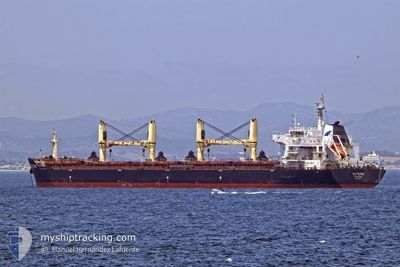
WHITE FIN
Bulk Carrier
Current Trip
MY BTU
| Time Travelled | 3 days |
|---|---|
| Remaining Time | --- |
| Distance Travelled | 385.56 nm |
| Remaining Distance | --- |
| AVG Speed | 12.3 Knots |
| MAX Speed | 14.3 Knots |
| AVG Wind | 5.9 knots |
| MAX Wind | 10.7 knots |
| MIN Temp | 26.5°C / 79.7°F |
| MAX Temp | 29.6°C / 85.28°F |
| Draught | 9.2 m |
| Position Received | 21 d ago |
Current Position
| Longitude | 104.33327° |
|---|---|
| Latitude | 1.29211° |
| Status | Under way using engine |
| Speed | 11.1 Knots |
| Course | 64.3° |
| Area | Singapore Strait |
| Station | T-AIS |
| Position Received | 21 d ago |
Info
Information
The current position of WHITE FIN is in Singapore Strait with coordinates 1.29211° / 104.33327° as reported on 2024-03-29 07:23 by AIS to our vessel tracker app. The vessel's current speed is 11.1 Knots
The vessel WHITE FIN (IMO: 9607291, MMSI: 256608000) is a Bulk Carrier that was built in 2011 ( 13 years old ). It's sailing under the flag of [MT] Malta.
In this page you can find informations about the vessels current position, last detected port calls, and current voyage information. If the vessels is not in coverage by AIS you will find the latest position.
The current position of WHITE FIN is detected by our AIS receivers and we are not responsible for the reliability of the data. The last position was recorded while the vessel was in Coverage by the Ais receivers of our vessel tracking app.
The current draught of WHITE FIN as reported by AIS is 9.2 meters
Weather
| Temperature | 29°C / 84.2°F |
|---|---|
| Wind Speed | 8 knots |
| Direction | 63° ENE |
| Pressure | 1006.5 hPa |
| Humidity | 72.1 % |
| Cloud Coverage | 78 % |
Featured Company
Last Port Calls
| Port | Arrival | Departure | Time In Port |
|---|---|---|---|
| 2024-04-13 06:09 | 2024-04-17 04:30 | 3 d | |
| 2024-04-04 05:00 | 2024-04-10 13:44 | 6 d | |
| 2024-03-24 19:00 | 2024-03-28 10:33 | 3 d | |
| 2024-03-06 09:29 | 2024-03-06 18:22 | 8 h | |
| 2024-02-05 13:49 | 2024-02-14 15:48 | 9 d |
Last Trips
| Origin | Departure | Destination | Arrival | Distance | |
|---|---|---|---|---|---|
| 2024-04-10 21:44 | 2024-04-13 14:09 | 739.42 nm | |||
| 2024-03-28 18:33 | 2024-04-04 13:00 | 801.00 nm | |||
| 2024-02-14 18:48 | 2024-03-25 03:00 | 9666.36 nm | |||
| 2024-02-14 18:48 | 2024-03-06 11:29 | 4789.85 nm | |||
| 2024-01-19 13:40 | 2024-02-05 16:49 | 4399.05 nm |
Events
| Time | Event | Details | Position / Dest | Info |
|---|---|---|---|---|
| 2024-04-18 11:37 | STOP Moving |
-.25703 / 117.60146
MY BTU
|
Speed: 0.1 kn Course: 116° |
|
| 2024-04-17 04:42 | START Moving | 1.31 nm, South East of LAHAD DATU |
5.00167 / 118.37334
MY BTU
|
Speed: 8 kn Course: -1° |
| 2024-04-17 04:30 | PORT DEPARTURE |
|
5.00167 / 118.37334
MY BTU
|
Speed: Course: -1° |
| 2024-04-13 06:33 | STOP Moving |
5.01667 / 118.35167
[MY] LAHAD DATU
|
Speed: Course: -1° |
|
| 2024-04-13 06:09 | PORT ARRIVAL |
|
5.01167 / 118.35667
[MY] LAHAD DATU
|
Speed: 5 kn Course: 297° |
| 2024-04-10 14:09 | START Moving | 2.34 nm, North of BINTULU |
3.26000 / 113.04333
MY BTU
|
Speed: 4 kn Course: -1° |
| 2024-04-10 13:44 | PORT DEPARTURE |
|
3.26000 / 113.04333
MY BTU
|
Speed: 3 kn Course: 283° |