
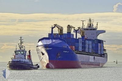
WANDA A
Container Ship
Current Trip
| Time Travelled | 3 days |
|---|---|
| Remaining Time | --- |
| Distance Travelled | 798.59 nm |
| Remaining Distance | --- |
| AVG Speed | 14.3 Knots |
| MAX Speed | 16.7 Knots |
| AVG Wind | 7.9 knots |
| MAX Wind | 25 knots |
| MIN Temp | 10.6°C / 51.08°F |
| MAX Temp | 17.8°C / 64.04°F |
| Draught | 8.5 m |
| Position Received | 1 d ago |
Current Position
| Longitude | --- |
|---|---|
| Latitude | --- |
| Status | Under way using engine |
| Speed | 15.6 Knots |
| Course | 336.4° |
| Area | Tyrrhenian Sea |
| Station | T-AIS |
| Position Received | 1 d ago |
Info
Information
The current position of WANDA A is in Tyrrhenian Sea with coordinates 39.45949° / 15.11664° as reported on 2025-12-08 01:39 by AIS to our vessel tracker app. The vessel's current speed is 15.6 Knots
The vessel WANDA A (IMO: 9415947, MMSI: 229111000) is a Container Ship that was built in 2009 ( 16 years old ). It's sailing under the flag of [MT] Malta.
In this page you can find informations about the vessels current position, last detected port calls, and current voyage information. If the vessels is not in coverage by AIS you will find the latest position.
The current position of WANDA A is detected by our AIS receivers and we are not responsible for the reliability of the data. The last position was recorded while the vessel was in Coverage by the Ais receivers of our vessel tracking app.
The current draught of WANDA A as reported by AIS is 8.5 meters
Weather
| Temperature | 15.4°C / 59.72°F |
|---|---|
| Wind Speed | --- |
| Direction | 249° WSW |
| Pressure | 1024.2 hPa |
| Humidity | 64.1 % |
| Cloud Coverage | 6 % |
Featured Company
Last Port Calls
| Port | Arrival | Departure | Time In Port |
|---|---|---|---|
| 2025-12-05 18:28 | 2025-12-06 05:57 | 11 h | |
| 2025-12-04 08:59 | 2025-12-04 23:29 | 14 h | |
| 2025-12-03 17:20 | 2025-12-04 03:55 | 10 h | |
| 2025-12-02 17:07 | 2025-12-03 10:19 | 17 h | |
| 2025-11-27 16:59 | 2025-11-29 01:41 | 1 d | |
| 2025-11-25 20:17 | 2025-11-27 11:20 | 1 d | |
| 2025-11-23 15:33 | 2025-11-24 13:22 | 21 h | |
| 2025-11-20 10:09 | 2025-11-21 00:15 | 14 h | |
| 2025-11-18 18:09 | 2025-11-19 15:17 | 21 h | |
| 2025-11-17 13:54 | 2025-11-18 04:59 | 15 h |
Most Visited Ports (Last year)
| Port | Arrivals | |
|---|---|---|
| 12 | ||
| 12 | ||
| 11 | ||
| 8 | ||
| 7 | ||
| 7 |
Last Trips
| Origin | Departure | Destination | Arrival | Distance | |
|---|---|---|---|---|---|
| 2025-12-04 23:29 | 2025-12-05 18:28 | 256.29 nm | |||
| 2025-12-04 03:55 | 2025-12-04 08:59 | 45.08 nm | |||
| 2025-12-03 10:19 | 2025-12-03 17:20 | 57.84 nm | |||
| 2025-11-29 01:41 | 2025-12-02 17:07 | 1312.24 nm | |||
| 2025-11-27 11:20 | 2025-11-27 16:59 | 54.50 nm | |||
| 2025-11-24 13:22 | 2025-11-25 20:17 | 367.16 nm | |||
| 2025-11-21 00:15 | 2025-11-23 15:33 | 800.87 nm | |||
| 2025-11-19 15:17 | 2025-11-20 10:09 | 257.22 nm | |||
| 2025-11-18 04:59 | 2025-11-18 18:09 | 60.76 nm | |||
| 2025-11-17 08:43 | 2025-11-17 13:54 | 58.53 nm |
Events
| Time | Event | Details | Position / Dest | Info |
|---|---|---|---|---|
| 2025-12-08 07:12 | STOP Moving | 2.49 nm, South West of ARECHI |
40.60873 / 14.78406
ITSAL
|
Speed: 0.3 kn Course: 281° |
| 2025-12-08 01:39 | OUT of Coverage |
39.45949 / 15.11664
Tyrrhenian Sea
ITSAL
|
Speed: 15.6 kn Course: 336.4° |
|
| 2025-12-08 01:37 | Status Changed | Under way using engine Default |
39.44985 / 15.12203
ITSAL
|
Speed: 16 kn Course: 339° |
| 2025-12-08 01:37 | IN Coverage |
39.45225 / 15.12067
Tyrrhenian Sea
ITSAL
|
Speed: 15.6 kn Course: 336.5° |
|
| 2025-12-07 23:58 | Status Changed | Default Under way using engine |
39.04351 / 15.33325
ITSAL
|
Speed: 15.5 kn Course: 338.5° |
| 2025-12-07 23:52 | OUT of Coverage |
39.01895 / 15.34539
Tyrrhenian Sea
ITSAL
|
Speed: 15.5 kn Course: 338.5° |
|
| 2025-12-07 20:31 | Change Sea Area | Italian part of the Tyrrhenian Sea Italian part of the Ionian Sea |
38.25537 / 15.67089
Tyrrhenian Sea
ITSAL
|
Speed: 13.4 kn Course: 63.6° |
| 2025-12-07 16:06 | Detected in Sea | Italian part of the Ionian Sea |
37.68791 / 16.38979
Ionian Sea
ITSAL
|
Speed: 16.3 kn Course: 285.7° |
| 2025-12-07 16:06 | Status Changed | Under way using engine Default |
37.68791 / 16.38979
ITSAL
|
Speed: 16.1 kn Course: 284° |
| 2025-12-07 16:06 | IN Coverage |
37.68791 / 16.38979
Ionian Sea
ITSAL
|
Speed: 16.3 kn Course: 285.7° |