
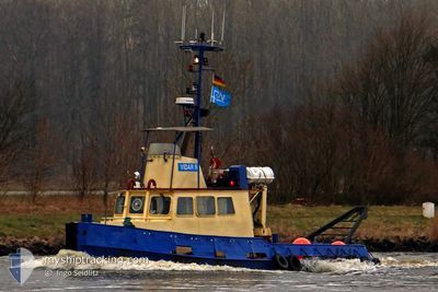
VIDAR-R
Tug
Current Trip
| Time Travelled | 1 day |
|---|---|
| Remaining Time | 1 day |
| Distance Travelled | 181.71 nm |
| Remaining Distance | 231.71 nm |
| AVG Speed | 7 Knots |
| MAX Speed | 9.6 Knots |
| AVG Wind | 11.2 knots |
| MAX Wind | 19.1 knots |
| MIN Temp | 4.5°C / 40.1°F |
| MAX Temp | 6.9°C / 44.42°F |
| Draught | 2.5 m |
| Position Received | Now |
Current Position
| Longitude | 10.99178° |
|---|---|
| Latitude | 57.53225° |
| Status | Under way using engine |
| Speed | 8.3 Knots |
| Course | 156.4° |
| Area | Kattegat |
| Station | T-AIS |
| Position Received | Now |
Info
Information
The current position of VIDAR-R is in Kattegat with coordinates 57.53225° / 10.99178° as reported on 2024-04-24 21:02 by AIS to our vessel tracker app. The vessel's current speed is 8.3 Knots and is heading at the port of GEDSER. The estimated time of arrival as calculated by MyShipTracking vessel tracking app is 2024-04-26 01:06 LT
The vessel VIDAR-R (MMSI: 219003406) is a Tug It's sailing under the flag of [DK] Denmark.
In this page you can find informations about the vessels current position, last detected port calls, and current voyage information. If the vessels is not in coverage by AIS you will find the latest position.
The current position of VIDAR-R is detected by our AIS receivers and we are not responsible for the reliability of the data. The last position was recorded while the vessel was in Coverage by the Ais receivers of our vessel tracking app.
The current draught of VIDAR-R as reported by AIS is 2.5 meters
Weather
| Temperature | 5.5°C / 41.9°F |
|---|---|
| Wind Speed | 5 knots |
| Direction | 132° SE |
| Pressure | 1007 hPa |
| Humidity | 73.6 % |
| Cloud Coverage | 100 % |
Featured Company
Last Port Calls
| Port | Arrival | Departure | Time In Port |
|---|---|---|---|
| 2024-04-23 00:46 | 2024-04-23 09:52 | 9 h | |
| 2024-04-20 05:42 | 2024-04-20 07:23 | 1 h | |
| 2024-04-18 18:25 | 2024-04-18 18:50 | 25 m | |
| 2024-04-17 17:56 | 2024-04-17 18:15 | 18 m | |
| 2024-04-16 21:48 | 2024-04-17 12:12 | 14 h | |
| 2024-04-15 12:57 | 2024-04-16 02:56 | 13 h | |
| 2024-04-15 06:43 | 2024-04-15 12:51 | 6 h | |
| 2024-04-13 18:37 | 2024-04-15 06:31 | 1 d | |
| 2024-04-08 09:09 | 2024-04-13 04:41 | 4 d | |
| 2024-04-06 11:10 | 2024-04-08 05:04 | 1 d |
Most Visited Ports (Last year)
| Port | Arrivals | |
|---|---|---|
| 51 | ||
| 26 | ||
| 11 | ||
| 5 | ||
| 5 | ||
| 4 |
Last Trips
| Origin | Departure | Destination | Arrival | Distance | |
|---|---|---|---|---|---|
| 2024-04-20 09:23 | 2024-04-23 02:46 | 247.01 nm | |||
| 2024-04-18 20:50 | 2024-04-20 07:42 | 186.44 nm | |||
| 2024-04-17 20:15 | 2024-04-18 20:25 | 130.12 nm | |||
| 2024-04-17 14:12 | 2024-04-17 19:56 | 48.15 nm | |||
| 2024-04-16 04:56 | 2024-04-16 23:48 | 45.68 nm | |||
| 2024-04-15 14:51 | 2024-04-15 14:57 | 0.67 nm | |||
| 2024-04-15 08:31 | 2024-04-15 08:43 | 1.39 nm | |||
| 2024-04-13 06:41 | 2024-04-13 20:37 | 118.89 nm | |||
| 2024-04-08 07:04 | 2024-04-08 11:09 | 10.55 nm | |||
| 2024-04-03 10:22 | 2024-04-06 13:10 | 372.70 nm |
Events
| Time | Event | Details | Position / Dest | Info |
|---|---|---|---|---|
| 2024-04-24 19:05 | Change Sea Area | Danish part of the Kattegat Danish part of the Skaggerak |
57.74854 / 10.72242
Kattegat
GEDSER BEACH
|
Speed: 8 kn Course: 128.4° |
| 2024-04-24 14:49 | Destination Changed | GEDSER BEACH GEDSER REV |
57.51167 / 9.81342
GEDSER BEACH
|
Speed: 8.1 kn Course: 34.1° |
| 2024-04-24 14:49 | ETA Changed | 2024/04/26 15:00 2024/04/24 18:00 |
57.51167 / 9.81342
GEDSER BEACH
|
Speed: 8.1 kn Course: 34.1° |
| 2024-04-24 14:35 | Destination Changed | GEDSER REV GUARD END 650M PIPE |
57.48694 / 9.78097
GEDSER REV
|
Speed: 7.5 kn Course: 25.8° |
| 2024-04-24 14:32 | START Moving | 9.18 nm, South West of HIRTSHALS |
57.48116 / 9.77576
GUARD END 650M PIPE
|
Speed: 7 kn Course: 21.9° |
| 2024-04-24 14:23 | STOP Moving | 9.28 nm, South West of HIRTSHALS |
57.47902 / 9.77598
GUARD END 650M PIPE
|
Speed: 0.3 kn Course: 511° |
| 2024-04-24 14:17 | START Moving | 9.42 nm, South West of HIRTSHALS |
57.47656 / 9.77429
GUARD END 650M PIPE
|
Speed: 3.3 kn Course: 16.9° |
| 2024-04-24 14:05 | STOP Moving | 9.37 nm, South West of HIRTSHALS |
57.47556 / 9.77937
GUARD END 650M PIPE
|
Speed: Course: 511° |
| 2024-04-24 13:59 | START Moving | 9.27 nm, South West of HIRTSHALS |
57.47566 / 9.78363
GUARD END 650M PIPE
|
Speed: 4.6 kn Course: 276.4° |
| 2024-04-24 13:46 | STOP Moving | 9.19 nm, South West of HIRTSHALS |
57.47585 / 9.78727
GUARD END 650M PIPE
|
Speed: Course: 511° |