
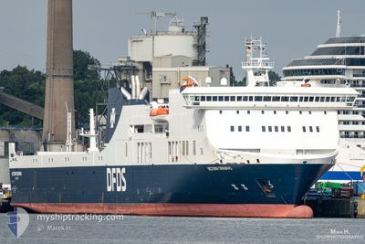
VICTORIA SEAWAYS
Ro-Ro/Passenger Ship
Current Trip
| Trip Time | 19 h, 41 mins |
|---|---|
| Trip Distance | 400.62 nm |
| AVG Speed | 18.7 Knots |
| MAX Speed | 22 Knots |
| Draught | 6.3 m |
| AVG Wind | 8.2 knots |
| MAX Wind | 12 knots |
| MIN Temp | 2.8°C / 37.04°F |
| MAX Temp | 5.2°C / 41.36°F |
| Position Received | 5 m ago |
Current Position
| Longitude | --- |
|---|---|
| Latitude | --- |
| Status | Moored |
| Speed | |
| Course | 231° |
| Area | Baltic Sea |
| Station | T-AIS |
| Position Received | 5 m ago |
Info
Information
The current position of VICTORIA SEAWAYS is in Baltic Sea with coordinates 54.33559° / 10.16716° as reported on 2024-12-11 18:18 by AIS to our vessel tracker app. The vessel's current speed is 0 Knots and is currently inside the port of KIEL.
The vessel VICTORIA SEAWAYS (IMO: 9350721, MMSI: 277408000) is a Ro-Ro/Passenger Ship that was built in 2009 ( 15 years old ). It's sailing under the flag of [LT] Lithuania.
In this page you can find informations about the vessels current position, last detected port calls, and current voyage information. If the vessels is not in coverage by AIS you will find the latest position.
The current position of VICTORIA SEAWAYS is detected by our AIS receivers and we are not responsible for the reliability of the data. The last position was recorded while the vessel was in Coverage by the Ais receivers of our vessel tracking app.
The current draught of VICTORIA SEAWAYS as reported by AIS is 6.3 meters
Weather
| Temperature | 3°C / 37.4°F |
|---|---|
| Wind Speed | 6 knots |
| Direction | 221° SW |
| Pressure | 1028.6 hPa |
| Humidity | 90.8 % |
| Cloud Coverage | 70 % |
Featured Company
Last Port Calls
| Port | Arrival | Departure | Time In Port |
|---|---|---|---|
| 2024-12-11 15:59 | |||
| 2024-12-10 15:26 | 2024-12-10 20:18 | 4 h | |
| 2024-12-08 18:28 | 2024-12-09 18:56 | 1 d | |
| 2024-12-07 17:16 | 2024-12-07 21:55 | 4 h | |
| 2024-12-06 16:57 | 2024-12-06 20:59 | 4 h | |
| 2024-12-05 16:20 | 2024-12-05 20:37 | 4 h | |
| 2024-12-04 16:05 | 2024-12-04 20:39 | 4 h | |
| 2024-12-03 15:20 | 2024-12-03 20:02 | 4 h | |
| 2024-12-01 18:29 | 2024-12-02 19:01 | 1 d | |
| 2024-11-30 17:23 | 2024-11-30 21:52 | 4 h |
Last Trips
| Origin | Departure | Destination | Arrival | Distance | |
|---|---|---|---|---|---|
| 2024-12-10 22:18 | 2024-12-11 16:59 | 400.62 nm | |||
| 2024-12-09 19:56 | 2024-12-10 17:26 | 398.57 nm | |||
| 2024-12-07 23:55 | 2024-12-08 19:28 | 400.80 nm | |||
| 2024-12-06 21:59 | 2024-12-07 19:16 | 396.57 nm | |||
| 2024-12-05 22:37 | 2024-12-06 17:57 | 400.48 nm | |||
| 2024-12-04 21:39 | 2024-12-05 18:20 | 397.89 nm | |||
| 2024-12-03 22:02 | 2024-12-04 17:05 | 401.35 nm | |||
| 2024-12-02 20:01 | 2024-12-03 17:20 | 398.10 nm | |||
| 2024-11-30 23:52 | 2024-12-01 19:29 | 400.62 nm | |||
| 2024-11-29 22:03 | 2024-11-30 19:23 | 398.20 nm |
Events
| Time | Event | Details | Position / Dest | Info |
|---|---|---|---|---|
| 2024-12-11 17:50 | ETA Changed | 2025/11/12 16:30 2024/12/11 16:30 |
54.33557 / 10.16713
[DE] KIEL
|
Speed: Course: 233° |
| 2024-12-11 16:23 | Status Changed | Moored Under way using engine |
54.33561 / 10.16716
[DE] KIEL
|
Speed: Course: 232° |
| 2024-12-11 16:14 | STOP Moving |
54.33572 / 10.16691
[DE] KIEL
|
Speed: 0.3 kn Course: 204° |
|
| 2024-12-11 15:59 | PORT ARRIVAL |
|
54.36256 / 10.16592
[DE] KIEL
|
Speed: 10.3 kn Course: 200.5° |
| 2024-12-11 14:49 | Change Sea Area | German part of the Baltic Sea Danish part of the Baltic Sea |
54.56304 / 10.55405
Baltic Sea
LTKLJ-DEKEL-LTKLJ
|
Speed: 19.2 kn Course: 246.1° |
| 2024-12-11 14:23 | Change Sea Area | Danish part of the Baltic Sea German part of the Baltic Sea |
54.58315 / 10.78863
Baltic Sea
LTKLJ-DEKEL-LTKLJ
|
Speed: 18.5 kn Course: 265.1° |
| 2024-12-11 13:25 | Change Sea Area | German part of the Baltic Sea Danish part of the Baltic Sea |
54.56065 / 11.32895
Baltic Sea
LTKLJ-DEKEL-LTKLJ
|
Speed: 20.5 kn Course: 291.7° |
| 2024-12-11 11:56 | Change Sea Area | Danish part of the Baltic Sea German part of the Baltic Sea |
54.44197 / 12.13645
Baltic Sea
LTKLJ-DEKEL-LTKLJ
|
Speed: 19.7 kn Course: 263.7° |
| 2024-12-11 11:44 | Change Sea Area | German part of the Baltic Sea Danish part of the Baltic Sea |
54.48568 / 12.20688
Baltic Sea
LTKLJ-DEKEL-LTKLJ
|
Speed: 20.2 kn Course: 196.9° |
| 2024-12-11 11:08 | Change Sea Area | Danish part of the Baltic Sea German part of the Baltic Sea |
54.65011 / 12.38902
Baltic Sea
LTKLJ-DEKEL-LTKLJ
|
Speed: 20.6 kn Course: 235.9° |