
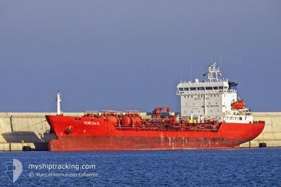
NQ ZINNIA
Oil/Chemical Tanker
Current Trip
SNDKR
| Time Travelled | 10 days |
|---|---|
| Remaining Time | --- |
| Distance Travelled | 2412.62 nm |
| Remaining Distance | --- |
| AVG Speed | 11.2 Knots |
| MAX Speed | 13.1 Knots |
| AVG Wind | 8.1 knots |
| MAX Wind | 32.7 knots |
| MIN Temp | 24.6°C / 76.28°F |
| MAX Temp | 30.5°C / 86.9°F |
| Draught | 8 m |
| Position Received | 25 d ago |
Current Position
| Longitude | -15.28698° |
|---|---|
| Latitude | 27.57686° |
| Status | Under way using engine |
| Speed | 12.3 Knots |
| Course | 205.2° |
| Area | North Atlantic Ocean |
| Station | T-AIS |
| Position Received | 25 d ago |
Info
Information
The current position of NQ ZINNIA is in North Atlantic Ocean with coordinates 27.57686° / -15.28698° as reported on 2024-03-24 06:35 by AIS to our vessel tracker app. The vessel's current speed is 12.3 Knots
The vessel NQ ZINNIA (IMO: 9150327, MMSI: 246347000) is a Oil/Chemical Tanker that was built in 1998 ( 26 years old ). It's sailing under the flag of [NL] Netherlands.
In this page you can find informations about the vessels current position, last detected port calls, and current voyage information. If the vessels is not in coverage by AIS you will find the latest position.
The current position of NQ ZINNIA is detected by our AIS receivers and we are not responsible for the reliability of the data. The last position was recorded while the vessel was in Coverage by the Ais receivers of our vessel tracking app.
The current draught of NQ ZINNIA as reported by AIS is 8 meters
Weather
| Temperature | 29.4°C / 84.92°F |
|---|---|
| Wind Speed | 5 knots |
| Direction | 203° SSW |
| Pressure | 1008 hPa |
| Humidity | 76.3 % |
| Cloud Coverage | 100 % |
Featured Company
Last Port Calls
| Port | Arrival | Departure | Time In Port |
|---|---|---|---|
| 2024-04-06 19:18 | 2024-04-08 14:07 | 1 d | |
| 2024-04-01 22:35 | 2024-04-02 07:47 | 9 h | |
| 2024-03-23 15:01 | 2024-03-24 03:25 | 12 h | |
| 2024-03-19 21:36 | 2024-03-20 13:05 | 15 h | |
| 2024-03-12 01:03 | 2024-03-13 19:15 | 1 d | |
| 2024-03-05 22:20 | 2024-03-06 08:32 | 10 h | |
| 2024-02-23 09:59 | 2024-02-24 23:29 | 1 d | |
| 2024-02-18 05:06 | |||
| 2024-02-01 20:52 |
Most Visited Ports (Last year)
| Port | Arrivals | |
|---|---|---|
| 6 | ||
| 4 | ||
| 4 | ||
| 3 | ||
| 3 | ||
| 2 |
Last Trips
| Origin | Departure | Destination | Arrival | Distance | |
|---|---|---|---|---|---|
| 2024-04-02 07:47 | 2024-04-06 19:18 | 1252.41 nm | |||
| 2024-03-24 03:25 | 2024-04-01 22:35 | 902.94 nm | |||
| 2024-03-20 14:05 | 2024-03-23 15:01 | 704.00 nm | |||
| 2024-03-13 20:15 | 2024-03-19 22:36 | 1128.36 nm | |||
| 2024-03-06 08:32 | 2024-03-12 02:03 | 1233.57 nm | |||
| 2024-02-24 23:29 | 2024-03-05 22:20 | 2103.00 nm | |||
| 2024-02-01 20:52 | 2024-02-18 06:06 | 1504.11 nm |
Events
| Time | Event | Details | Position / Dest | Info |
|---|---|---|---|---|
| 2024-04-14 07:30 | START Moving | 0.47 nm, North East of DOUALA |
4.06265 / 9.69319
SNDKR
|
Speed: 5.7 kn Course: 180° |
| 2024-04-13 08:46 | STOP Moving | 0.64 nm, North of DOUALA |
4.06600 / 9.69257
SNDKR
|
Speed: 0.2 kn Course: 351° |
| 2024-04-13 06:40 | START Moving | 12.45 nm, South West of DOUALA |
3.90562 / 9.54556
SNDKR
|
Speed: 6.1 kn Course: 5° |
| 2024-04-13 01:37 | STOP Moving | 12.74 nm, South West of DOUALA |
3.90011 / 9.54425
SNDKR
|
Speed: 0.2 kn Course: 90° |