
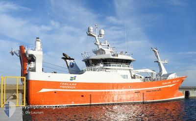
TORLAND
Fishing
Current Trip
FISHINGROUND
| Time Travelled | 4 days |
|---|---|
| Remaining Time | --- |
| Distance Travelled | 591.72 nm |
| Remaining Distance | --- |
| AVG Speed | 6.1 Knots |
| MAX Speed | 11.7 Knots |
| AVG Wind | 16.3 knots |
| MAX Wind | 30.8 knots |
| MIN Temp | 4.5°C / 40.1°F |
| MAX Temp | 7.9°C / 46.22°F |
| Draught | 7.1 m |
| Position Received | Now |
Current Position
| Longitude | 4.79894° |
|---|---|
| Latitude | 56.15896° |
| Status | Engaged in Fishing |
| Speed | 1.7 Knots |
| Course | 61° |
| Area | North Sea |
| Station | T-AIS |
| Position Received | Now |
Info
Information
The current position of TORLAND is in North Sea with coordinates 56.15896° / 4.79894° as reported on 2024-04-19 23:24 by AIS to our vessel tracker app. The vessel's current speed is 1.7 Knots
The vessel TORLAND (IMO: 9840104, MMSI: 265028000) is a Fishing It's sailing under the flag of [SE] Sweden.
In this page you can find informations about the vessels current position, last detected port calls, and current voyage information. If the vessels is not in coverage by AIS you will find the latest position.
The current position of TORLAND is detected by our AIS receivers and we are not responsible for the reliability of the data. The last position was recorded while the vessel was in Coverage by the Ais receivers of our vessel tracking app.
The current draught of TORLAND as reported by AIS is 7.1 meters
Weather
| Temperature | 5.4°C / 41.72°F |
|---|---|
| Wind Speed | 27 knots |
| Direction | 338° NNW |
| Pressure | 1015.2 hPa |
| Humidity | 88.3 % |
| Cloud Coverage | 100 % |
Featured Company
Last Port Calls
| Port | Arrival | Departure | Time In Port |
|---|---|---|---|
| 2024-03-27 06:33 | 2024-04-15 12:37 | 19 d | |
| 2024-03-26 16:53 | 2024-03-27 05:14 | 12 h | |
| 2024-03-17 07:06 | 2024-03-17 16:15 | 9 h | |
| 2024-02-21 09:29 | 2024-03-07 09:19 | 14 d | |
| 2024-02-20 14:25 | 2024-02-21 07:52 | 17 h | |
| 2024-02-11 03:47 | 2024-02-12 14:39 | 1 d |
Last Trips
| Origin | Departure | Destination | Arrival | Distance | |
|---|---|---|---|---|---|
| 2024-03-27 06:14 | 2024-03-27 07:33 | 7.77 nm | |||
| 2024-03-17 17:15 | 2024-03-26 17:53 | 729.15 nm | |||
| 2024-03-07 10:19 | 2024-03-17 08:06 | 813.51 nm | |||
| 2024-02-21 08:52 | 2024-02-21 10:29 | 9.02 nm | |||
| 2024-02-12 15:39 | 2024-02-20 15:25 | 1076.99 nm | |||
| 2024-01-29 15:28 | 2024-02-11 04:47 | 1165.73 nm |
Events
| Time | Event | Details | Position / Dest | Info |
|---|---|---|---|---|
| 2024-04-19 23:15 | START Moving |
56.16181 / 4.79566
FISHINGROUND
|
Speed: 3.3 kn Course: 63° |
|
| 2024-04-19 23:06 | STOP Moving |
56.16522 / 4.79245
FISHINGROUND
|
Speed: 0.1 kn Course: 345° |
|
| 2024-04-18 04:36 | START Moving |
56.05100 / 5.01665
FISHINGROUND
|
Speed: 3.2 kn Course: 0° |
|
| 2024-04-18 03:16 | STOP Moving |
56.06889 / 5.00591
FISHINGROUND
|
Speed: 0.3 kn Course: 328° |
|
| 2024-04-18 02:00 | START Moving |
56.00540 / 5.06116
FISHINGROUND
|
Speed: 3.1 kn Course: 38° |
|
| 2024-04-17 20:01 | STOP Moving |
56.05600 / 5.01898
FISHINGROUND
|
Speed: 0.3 kn Course: 56° |
|
| 2024-04-15 23:47 | Detected in Sea | Danish part of the North Sea |
57.27034 / 8.33367
North Sea
|
Speed: 7.3 kn Course: 246.7° |
| 2024-04-15 13:35 | Destination Changed | FISHINGROUND SKAGEN |
57.77341 / 10.63410
FISHINGROUND
|
Speed: 8.2 kn Course: 271.8° |
| 2024-04-15 13:35 | Status Changed | Engaged in Fishing Under way using engine |
57.77341 / 10.63410
SKAGEN
|
Speed: 8.2 kn Course: 270.6° |
| 2024-04-15 13:11 | Change Sea Area | Danish part of the Skaggerak Danish part of the Kattegat |
57.75585 / 10.72781
Skaggerak
|
Speed: 9.6 kn Course: 8.9° |