
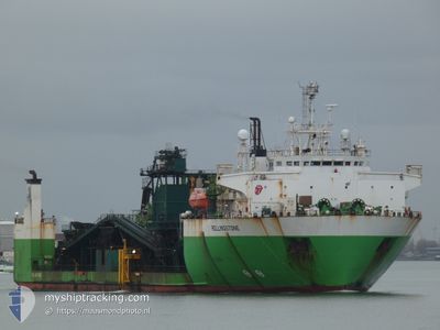
ROLLINGSTONE
Pipe Burying Vessel
Current Trip
TUXPAN
| Time Travelled | 7 days |
|---|---|
| Remaining Time | --- |
| Distance Travelled | 0.31 nm |
| Remaining Distance | --- |
| AVG Speed | --- |
| MAX Speed | --- |
| AVG Wind | 10.7 knots |
| MAX Wind | 14.3 knots |
| MIN Temp | 24.8°C / 76.64°F |
| MAX Temp | 25.9°C / 78.62°F |
| Draught | 5.5 m |
| Position Received | 7 d ago |
Current Position
| Longitude | -97.28926° |
|---|---|
| Latitude | 21.20658° |
| Status | Restricted manoeuverability |
| Speed | 0.6 Knots |
| Course | 70° |
| Area | Gulf of Mexico |
| Station | T-AIS |
| Position Received | 7 d ago |
Info
Information
The current position of ROLLINGSTONE is in Gulf of Mexico with coordinates 21.20658° / -97.28926° as reported on 2024-04-18 09:57 by AIS to our vessel tracker app. The vessel's current speed is 0.6 Knots
The vessel ROLLINGSTONE (IMO: 7814101, MMSI: 245746000) is a Pipe Burying Vessel that was built in 1979 ( 45 years old ). It's sailing under the flag of [NL] Netherlands.
In this page you can find informations about the vessels current position, last detected port calls, and current voyage information. If the vessels is not in coverage by AIS you will find the latest position.
The current position of ROLLINGSTONE is detected by our AIS receivers and we are not responsible for the reliability of the data. The last position was recorded while the vessel was in Coverage by the Ais receivers of our vessel tracking app.
The current draught of ROLLINGSTONE as reported by AIS is 5.5 meters
Weather
| Temperature | 25°C / 77°F |
|---|---|
| Wind Speed | 5 knots |
| Direction | 71° ENE |
| Pressure | 1010.3 hPa |
| Humidity | 93.6 % |
| Cloud Coverage | 66 % |
Featured Company
Events
| Time | Event | Details | Position / Dest | Info |
|---|---|---|---|---|
| 2024-04-18 09:57 | OUT of Coverage |
21.20658 / -97.28926
Gulf of Mexico
|
Speed: 0.6 kn Course: 242° |
|
| 2024-04-18 09:57 | IN Coverage |
21.20658 / -97.28926
Gulf of Mexico
|
Speed: 0.6 kn Course: 242° |
|
| 2024-04-18 01:02 | OUT of Coverage |
21.20452 / -97.29259
Gulf of Mexico
|
Speed: 0.1 kn Course: 57.1° |
|
| 2024-04-18 01:01 | IN Coverage |
21.20450 / -97.29264
Gulf of Mexico
|
Speed: 0.1 kn Course: 76.9° |
|
| 2024-04-17 22:48 | OUT of Coverage |
21.20556 / -97.29163
Gulf of Mexico
|
Speed: 2.6 kn Course: 261.5° |
|
| 2024-04-17 22:48 | IN Coverage |
21.20556 / -97.29163
Gulf of Mexico
|
Speed: 2.6 kn Course: 261.5° |
|
| 2024-04-17 22:48 | PORT DEPARTURE |
|
21.20556 / -97.29163
TUXPAN
|
Speed: Course: 231° |
| 2024-04-17 08:29 | OUT of Coverage |
20.94798 / -97.35008
Gulf of Mexico
[MX] TUXPAN
|
Speed: Course: 298.6° |
|
| 2024-04-17 08:11 | IN Coverage |
20.94797 / -97.35008
Gulf of Mexico
[MX] TUXPAN
|
Speed: Course: 321.8° |
|
| 2024-04-17 01:05 | OUT of Coverage |
20.94821 / -97.34979
Gulf of Mexico
[MX] TUXPAN
|
Speed: Course: 1.8° |