
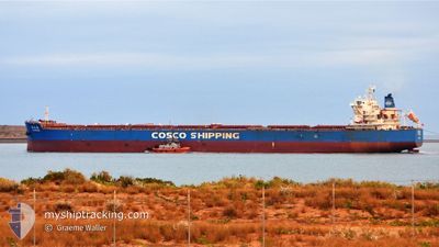
TAO HUA HAI
Bulk Carrier
Current Trip
QD CN
| Time Travelled | 3 days |
|---|---|
| Remaining Time | --- |
| Distance Travelled | 972.42 nm |
| Remaining Distance | --- |
| AVG Speed | 10.4 Knots |
| MAX Speed | 12.2 Knots |
| AVG Wind | 10.8 knots |
| MAX Wind | 20 knots |
| MIN Temp | 27.2°C / 80.96°F |
| MAX Temp | 29.6°C / 85.28°F |
| Draught | 14.6 m |
| Position Received | 3 d ago |
Current Position
| Longitude | 117.70530° |
|---|---|
| Latitude | -16.67553° |
| Status | Under way using engine |
| Speed | 11.6 Knots |
| Course | 347.2° |
| Area | Indian Ocean |
| Station | T-AIS |
| Position Received | 3 d ago |
Info
Information
The current position of TAO HUA HAI is in Indian Ocean with coordinates -16.67553° / 117.70530° as reported on 2024-04-15 05:47 by AIS to our vessel tracker app. The vessel's current speed is 11.6 Knots
The vessel TAO HUA HAI (IMO: 9620504, MMSI: 414070000) is a Bulk Carrier that was built in 2012 ( 12 years old ). It's sailing under the flag of [CN] China.
In this page you can find informations about the vessels current position, last detected port calls, and current voyage information. If the vessels is not in coverage by AIS you will find the latest position.
The current position of TAO HUA HAI is detected by our AIS receivers and we are not responsible for the reliability of the data. The last position was recorded while the vessel was in Coverage by the Ais receivers of our vessel tracking app.
The current draught of TAO HUA HAI as reported by AIS is 14.6 meters
Weather
| Temperature | 29.5°C / 85.1°F |
|---|---|
| Wind Speed | 7 knots |
| Direction | 316° NW |
| Pressure | 1006.9 hPa |
| Humidity | 72.4 % |
| Cloud Coverage | 56 % |
Featured Company
Last Port Calls
| Port | Arrival | Departure | Time In Port |
|---|---|---|---|
| 2024-04-13 02:01 | 2024-04-14 09:10 | 1 d | |
| 2024-03-19 18:12 | 2024-03-22 13:45 | 2 d | |
| 2024-03-01 01:37 | 2024-03-02 14:04 | 1 d | |
| 2024-02-10 10:02 | 2024-02-13 06:22 | 2 d |
Most Visited Ports (Last year)
| Port | Arrivals | |
|---|---|---|
| 10 | ||
| 3 | ||
| 1 | ||
| 1 | ||
| 1 | ||
| 1 |
Last Trips
| Origin | Departure | Destination | Arrival | Distance | |
|---|---|---|---|---|---|
| 2024-03-22 21:45 | 2024-04-13 10:01 | 3657.56 nm | |||
| 2024-03-02 22:04 | 2024-03-20 02:12 | 3602.97 nm | |||
| 2024-02-13 14:22 | 2024-03-01 09:37 | 3895.00 nm | |||
| 2024-01-24 04:43 | 2024-02-10 18:02 | 3898.79 nm |
Events
| Time | Event | Details | Position / Dest | Info |
|---|---|---|---|---|
| 2024-04-15 05:52 | Status Changed | Default Under way using engine |
-16.65914 / 117.70158
QD CN
|
Speed: 11.6 kn Course: 347.2° |
| 2024-04-15 05:47 | OUT of Coverage |
-16.67553 / 117.70530
Indian Ocean
QD CN
|
Speed: 11.6 kn Course: 347.2° |
|
| 2024-04-15 04:50 | Status Changed | Under way using engine Default |
-16.86085 / 117.74706
QD CN
|
Speed: 12 kn Course: 348° |
| 2024-04-15 04:41 | Status Changed | Default Under way using engine |
-16.89036 / 117.75355
QD CN
|
Speed: 11.9 kn Course: 346.9° |
| 2024-04-15 04:41 | Status Changed | Under way using engine Default |
-16.89084 / 117.75367
QD CN
|
Speed: 11.9 kn Course: 347° |
| 2024-04-15 04:24 | Status Changed | Default Under way using engine |
-16.94799 / 117.76570
QD CN
|
Speed: 11.8 kn Course: 350.4° |
| 2024-04-15 04:14 | Status Changed | Under way using engine Default |
-16.97810 / 117.77130
QD CN
|
Speed: 11.8 kn Course: 350° |
| 2024-04-15 04:08 | Status Changed | Default Under way using engine |
-16.99647 / 117.77468
QD CN
|
Speed: 11.7 kn Course: 349.9° |
| 2024-04-15 04:01 | Status Changed | Under way using engine Default |
-17.01903 / 117.77885
QD CN
|
Speed: 11.9 kn Course: 350° |
| 2024-04-15 03:45 | Status Changed | Default Under way using engine |
-17.07271 / 117.78861
QD CN
|
Speed: 11.9 kn Course: 350.3° |