
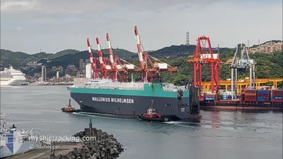
TAIPAN
Vehicles Carrier
Current Trip
| Trip Time | 2 days |
|---|---|
| Trip Distance | 686.46 nm |
| AVG Speed | 12.5 Knots |
| MAX Speed | 17.7 Knots |
| Draught | 8.7 m |
| AVG Wind | 8.6 knots |
| MAX Wind | 18.3 knots |
| MIN Temp | 0.1°C / 32.18°F |
| MAX Temp | 20.5°C / 68.9°F |
| Position Received | 1 m ago |
Current Position
| Longitude | --- |
|---|---|
| Latitude | --- |
| Status | Moored |
| Speed | |
| Course | 246° |
| Area | North Atlantic Ocean |
| Station | T-AIS |
| Position Received | 1 m ago |
Info
Information
The current position of TAIPAN is in North Atlantic Ocean with coordinates 39.24018° / -76.52976° as reported on 2025-12-07 12:02 by AIS to our vessel tracker app. The vessel's current speed is 0 Knots and is currently inside the port of DUNDALK.
The vessel TAIPAN (IMO: 9311866, MMSI: 308921000) is a Vehicles Carrier that was built in 2006 ( 19 years old ). It's sailing under the flag of [BS] Bahamas.
In this page you can find informations about the vessels current position, last detected port calls, and current voyage information. If the vessels is not in coverage by AIS you will find the latest position.
The current position of TAIPAN is detected by our AIS receivers and we are not responsible for the reliability of the data. The last position was recorded while the vessel was in Coverage by the Ais receivers of our vessel tracking app.
The current draught of TAIPAN as reported by AIS is 8.7 meters
Weather
| Temperature | 0.3°C / 32.54°F |
|---|---|
| Wind Speed | 4 knots |
| Direction | 331° NNW |
| Pressure | 1019.6 hPa |
| Humidity | 77.2 % |
| Cloud Coverage | 60 % |
Featured Company
Last Port Calls
| Port | Arrival | Departure | Time In Port |
|---|---|---|---|
| 2025-12-07 06:06 | |||
| 2025-12-04 09:09 | 2025-12-05 00:28 | 15 h | |
| 2025-11-28 12:21 | 2025-11-30 16:07 | 2 d | |
| 2025-11-25 05:05 | 2025-11-25 17:24 | 12 h | |
| 2025-11-22 05:18 | 2025-11-23 00:15 | 18 h | |
| 2025-11-17 22:58 | 2025-11-18 03:06 | 4 h | |
| 2025-11-17 21:01 | |||
| 2025-11-17 20:34 | |||
| 2025-11-17 19:02 | |||
| 2025-11-17 00:26 |
Most Visited Ports (Last year)
| Port | Arrivals | |
|---|---|---|
| 4 | ||
| 3 | ||
| 3 | ||
| 2 | ||
| 2 | ||
| 2 |
Last Trips
| Origin | Departure | Destination | Arrival | Distance | |
|---|---|---|---|---|---|
| 2025-12-05 00:28 | 2025-12-07 06:06 | 686.46 nm | |||
| 2025-11-30 16:07 | 2025-12-04 09:09 | 1448.13 nm | |||
| 2025-11-25 17:24 | 2025-11-28 12:21 | 612.69 nm | |||
| 2025-11-23 00:15 | 2025-11-25 05:05 | 637.07 nm | |||
| 2025-11-18 03:06 | 2025-11-22 05:18 | 1512.54 nm | |||
| 2025-11-04 17:57 | 2025-11-17 22:58 | 4598.68 nm | |||
| 2025-11-04 17:57 | 2025-11-17 21:01 | 4598.68 nm | |||
| 2025-11-04 17:57 | 2025-11-17 20:34 | 4598.68 nm | |||
| 2025-11-04 17:57 | 2025-11-17 19:02 | 4598.68 nm | |||
| 2025-11-04 17:57 | 2025-11-17 00:26 | 4598.60 nm |
Events
| Time | Event | Details | Position / Dest | Info |
|---|---|---|---|---|
| 2025-12-07 11:32 | Status Changed | Moored Under way using engine |
39.24018 / -76.52976
[US] DUNDALK
|
Speed: Course: 246° |
| 2025-12-07 11:06 | PORT ARRIVAL |
|
39.23819 / -76.53414
[US] DUNDALK
|
Speed: 0.5 kn Course: 253° |
| 2025-12-07 11:02 | STOP Moving | 0.25 nm, South East of DUNDALK |
39.23820 / -76.53438
USBAL
|
Speed: 0.3 kn Course: 322° |
| 2025-12-07 07:36 | Status Changed | Under way using engine Default |
38.54910 / -76.43116
USBAL
|
Speed: 17.1 kn Course: 335° |
| 2025-12-07 07:35 | Status Changed | Default Under way using engine |
38.54694 / -76.42990
USBAL
|
Speed: 17 kn Course: 335.5° |
| 2025-12-07 07:28 | Status Changed | Under way using engine Default |
38.51632 / -76.41198
USBAL
|
Speed: 17 kn Course: 336° |
| 2025-12-07 07:27 | Status Changed | Default Under way using engine |
38.51252 / -76.40977
USBAL
|
Speed: 17 kn Course: 333.5° |
| 2025-12-07 07:26 | Status Changed | Under way using engine Default |
38.50688 / -76.40637
USBAL
|
Speed: 16.9 kn Course: 334° |
| 2025-12-07 07:19 | IN Coverage |
38.51632 / -76.41198
North Atlantic Ocean
|
Speed: 17 kn Course: 335.5° |
|
| 2025-12-07 06:11 | OUT of Coverage |
38.18574 / -76.23353
North Atlantic Ocean
|
Speed: 16.7 kn Course: 356.2° |