
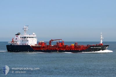
STOLT SANDERLING
Oil/Chemical Tanker
Current Trip
| Time Travelled | 5 h, 25 mins |
|---|---|
| Remaining Time | --- |
| Distance Travelled | 13.06 nm |
| Remaining Distance | --- |
| AVG Speed | 9 Knots |
| MAX Speed | 10.9 Knots |
| AVG Wind | 16.1 knots |
| MAX Wind | 16.4 knots |
| MIN Temp | 6°C / 42.8°F |
| MAX Temp | 6°C / 42.8°F |
| Draught | 5.2 m |
| Position Received | 4 h, 16 m ago |
Current Position
| Longitude | -0.97669° |
|---|---|
| Latitude | 54.81446° |
| Status | Under way using engine |
| Speed | 10.1 Knots |
| Course | 34.7° |
| Area | North Sea |
| Station | T-AIS |
| Position Received | 4 h, 16 m ago |
Info
Information
The current position of STOLT SANDERLING is in North Sea with coordinates 54.81446° / -0.97669° as reported on 2024-04-25 15:37 by AIS to our vessel tracker app. The vessel's current speed is 10.1 Knots
The vessel STOLT SANDERLING (IMO: 9518804, MMSI: 235095972) is a Oil/Chemical Tanker that was built in 2011 ( 13 years old ). It's sailing under the flag of [GB] United Kingdom.
In this page you can find informations about the vessels current position, last detected port calls, and current voyage information. If the vessels is not in coverage by AIS you will find the latest position.
The current position of STOLT SANDERLING is detected by our AIS receivers and we are not responsible for the reliability of the data. The last position was recorded while the vessel was in Coverage by the Ais receivers of our vessel tracking app.
The current draught of STOLT SANDERLING as reported by AIS is 5.2 meters
Weather
| Temperature | 6.5°C / 43.7°F |
|---|---|
| Wind Speed | 13 knots |
| Direction | 17° NNE |
| Pressure | 1003.3 hPa |
| Humidity | 65.1 % |
| Cloud Coverage | 77 % |
Featured Company
Last Port Calls
| Port | Arrival | Departure | Time In Port |
|---|---|---|---|
| 2024-04-24 19:22 | 2024-04-25 14:29 | 19 h | |
| 2024-04-23 10:10 | 2024-04-24 05:38 | 19 h | |
| 2024-04-18 16:22 | 2024-04-21 19:22 | 3 d | |
| 2024-04-17 12:07 | 2024-04-18 15:37 | 1 d | |
| 2024-04-15 03:48 | 2024-04-15 22:23 | 18 h | |
| 2024-04-12 21:19 | 2024-04-13 23:09 | 1 d | |
| 2024-04-07 20:06 | 2024-04-09 20:24 | 2 d | |
| 2024-04-05 11:15 | 2024-04-06 17:23 | 1 d | |
| 2024-04-04 23:03 | 2024-04-05 10:06 | 11 h | |
| 2024-04-03 08:40 | 2024-04-04 07:12 | 22 h |
Last Trips
| Origin | Departure | Destination | Arrival | Distance | |
|---|---|---|---|---|---|
| 2024-04-24 06:38 | 2024-04-24 20:22 | 151.03 nm | |||
| 2024-04-21 21:22 | 2024-04-23 11:10 | 402.05 nm | |||
| 2024-04-18 17:37 | 2024-04-18 18:22 | 10.07 nm | |||
| 2024-04-16 00:23 | 2024-04-17 14:07 | 357.07 nm | |||
| 2024-04-14 01:09 | 2024-04-15 05:48 | 338.81 nm | |||
| 2024-04-09 22:24 | 2024-04-12 23:19 | 464.53 nm | |||
| 2024-04-06 19:23 | 2024-04-07 22:06 | 293.45 nm | |||
| 2024-04-05 12:06 | 2024-04-05 13:15 | 10.15 nm | |||
| 2024-04-04 08:12 | 2024-04-05 01:03 | 159.96 nm | |||
| 2024-04-01 22:06 | 2024-04-03 09:40 | 180.24 nm |
Events
| Time | Event | Details | Position / Dest | Info |
|---|---|---|---|---|
| 2024-04-25 15:56 | Status Changed | Default Under way using engine |
54.85706 / -.92365
GB SUN
|
Speed: 10.1 kn Course: 34.7° |
| 2024-04-25 15:37 | OUT of Coverage |
54.81446 / -.97669
North Sea
GB SUN
|
Speed: 10.1 kn Course: 34.7° |
|
| 2024-04-25 15:34 | Status Changed | Under way using engine Default |
54.80773 / -.98492
GB SUN
|
Speed: 10.1 kn Course: 36° |
| 2024-04-25 15:25 | Status Changed | Default Under way using engine |
54.78619 / -1.01092
GB SUN
|
Speed: 10.3 kn Course: 34.2° |
| 2024-04-25 14:47 | Status Changed | Under way using engine Moored |
54.68986 / -1.10044
GB SUN
|
Speed: 10.5 kn Course: 16° |
| 2024-04-25 14:29 | PORT DEPARTURE |
|
54.64894 / -1.13994
GB SUN
|
Speed: 10.7 kn Course: 28° |
| 2024-04-25 14:26 | Draught Changed | 5.2 5.6 |
54.64080 / -1.14823
[GB] TEES
|
Speed: 10.7 kn Course: 30° |
| 2024-04-25 14:26 | Destination Changed | GB SUN GB TEE |
54.64080 / -1.14823
[GB] TEES
|
Speed: 10.7 kn Course: 30° |
| 2024-04-25 14:26 | ETA Changed | 2024/04/26 18:00 2024/04/24 18:00 |
54.64080 / -1.14823
[GB] TEES
|
Speed: 10.7 kn Course: 30° |
| 2024-04-25 14:14 | Status Changed | Moored Default |
54.60914 / -1.15772
[GB] TEES
|
Speed: 1.8 kn Course: 6° |