
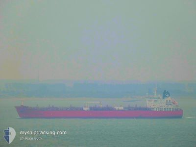
STI FULHAM
Tanker
Current Trip
| Time Travelled | 5 days |
|---|---|
| Remaining Time | 6 days |
| Distance Travelled | 939.40 nm |
| Remaining Distance | 1545.70 nm |
| AVG Speed | 9 Knots |
| MAX Speed | 15.4 Knots |
| AVG Wind | 11 knots |
| MAX Wind | 26 knots |
| MIN Temp | 14.2°C / 57.56°F |
| MAX Temp | 20.3°C / 68.54°F |
| Draught | 8.3 m |
| Position Received | 1 d ago |
Current Position
| Longitude | --- |
|---|---|
| Latitude | --- |
| Status | Under way using engine |
| Speed | 2 Knots |
| Course | 194° |
| Area | Alboran Sea |
| Station | T-AIS |
| Position Received | 1 d ago |
Info
Information
The current position of STI FULHAM is in Alboran Sea with coordinates 36.08135° / -4.53127° as reported on 2025-12-07 21:31 by AIS to our vessel tracker app. The vessel's current speed is 2 Knots and is heading at the port of TERNEUZEN. The estimated time of arrival as calculated by MyShipTracking vessel tracking app is 2025-12-15 13:19 LT
The vessel STI FULHAM (IMO: 9688374, MMSI: 538005400) is a Tanker It's sailing under the flag of [MH] Marshall Is.
In this page you can find informations about the vessels current position, last detected port calls, and current voyage information. If the vessels is not in coverage by AIS you will find the latest position.
The current position of STI FULHAM is detected by our AIS receivers and we are not responsible for the reliability of the data. The last position was recorded while the vessel was in Coverage by the Ais receivers of our vessel tracking app.
The current draught of STI FULHAM as reported by AIS is 8.3 meters
Weather
| Temperature | 16.6°C / 61.88°F |
|---|---|
| Wind Speed | 8 knots |
| Direction | 237° WSW |
| Pressure | 1022.3 hPa |
| Humidity | 78.2 % |
| Cloud Coverage | 6 % |
Featured Company
Last Port Calls
| Port | Arrival | Departure | Time In Port |
|---|---|---|---|
| 2025-11-29 11:22 | 2025-12-03 10:18 | 3 d | |
| 2025-11-24 10:43 | 2025-11-25 22:49 | 1 d | |
| 2025-11-21 11:56 | 2025-11-21 19:14 | 7 h | |
| 2025-11-18 01:07 | 2025-11-21 11:30 | 3 d | |
| 2025-11-17 09:42 | 2025-11-17 20:13 | 10 h | |
| 2025-11-09 14:14 | 2025-11-12 07:55 | 2 d | |
| 2025-10-31 10:39 | 2025-11-02 22:44 | 2 d | |
| 2025-10-28 13:56 | 2025-10-28 14:34 | 38 m | |
| 2025-10-26 00:05 | 2025-10-26 00:44 | 38 m | |
| 2025-10-17 10:24 | 2025-10-18 13:09 | 1 d |
Last Trips
| Origin | Departure | Destination | Arrival | Distance | |
|---|---|---|---|---|---|
| 2025-11-25 22:49 | 2025-11-29 11:22 | 762.73 nm | |||
| 2025-11-21 19:14 | 2025-11-24 10:43 | 758.92 nm | |||
| 2025-11-21 11:30 | 2025-11-21 11:56 | 2.28 nm | |||
| 2025-11-17 20:13 | 2025-11-18 01:07 | 58.33 nm | |||
| 2025-11-12 07:55 | 2025-11-17 09:42 | 1280.06 nm | |||
| 2025-11-02 22:44 | 2025-11-09 14:14 | 1281.41 nm | |||
| 2025-10-28 14:34 | 2025-10-31 10:39 | 698.69 nm | |||
| 2025-10-26 00:44 | 2025-10-28 13:56 | 3.18 nm | |||
| 2025-10-18 13:09 | 2025-10-26 00:05 | 713.70 nm | |||
| 2025-10-17 05:34 | 2025-10-17 10:24 | 56.44 nm |
Events
| Time | Event | Details | Position / Dest | Info |
|---|---|---|---|---|
| 2025-12-08 11:47 | START Moving |
35.92119 / -3.97285
FOR ORDERS
|
Speed: 3.2 kn Course: 58° |
|
| 2025-12-07 21:39 | Status Changed | Default Under way using engine |
36.07912 / -4.52663
FOR ORDERS
|
Speed: 2 kn Course: 194° |
| 2025-12-07 21:31 | OUT of Coverage |
36.08135 / -4.53127
Alboran Sea
|
Speed: 2 kn Course: 118.1° |
|
| 2025-12-07 21:09 | Status Changed | Under way using engine Default |
36.08748 / -4.54471
FOR ORDERS
|
Speed: 1.9 kn Course: 200° |
| 2025-12-07 20:56 | Status Changed | Default Under way using engine |
36.09130 / -4.55201
FOR ORDERS
|
Speed: 1.9 kn Course: 199° |
| 2025-12-07 20:32 | Status Changed | Under way using engine Default |
36.09707 / -4.56820
FOR ORDERS
|
Speed: 2 kn Course: -1° |
| 2025-12-07 20:25 | Status Changed | Default Under way using engine |
36.09857 / -4.57310
FOR ORDERS
|
Speed: 2 kn Course: 188° |
| 2025-12-07 20:12 | Status Changed | Under way using engine Default |
36.10160 / -4.58110
FOR ORDERS
|
Speed: 2 kn Course: -1° |
| 2025-12-07 20:06 | Status Changed | Default Under way using engine |
36.10166 / -4.58500
FOR ORDERS
|
Speed: 2.1 kn Course: 183° |
| 2025-12-07 03:41 | STOP Moving | 18.93 nm, East of GIBRALTAR |
36.16716 / -4.97394
FOR ORDERS
|
Speed: 0.3 kn Course: 208° |