
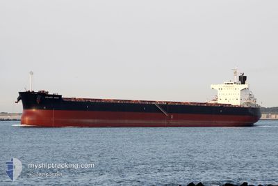
STAR MONA
Cargo
Current Trip
| Trip Time | 6 days |
|---|---|
| Trip Distance | 744.42 nm |
| AVG Speed | 9.5 Knots |
| MAX Speed | 9.5 Knots |
| Draught | 7.6 m |
| AVG Wind | 10.8 knots |
| MAX Wind | 20 knots |
| MIN Temp | 23.8°C / 74.84°F |
| MAX Temp | 29.1°C / 84.38°F |
| Position Received | 2 d ago |
Current Position
| Longitude | 49.45533° |
|---|---|
| Latitude | 27.70949° |
| Status | At anchor |
| Speed | 0.5 Knots |
| Course | 147° |
| Area | Persian Gulf |
| Station | T-AIS |
| Position Received | 2 d ago |
Info
Information
The current position of STAR MONA is in Persian Gulf with coordinates 27.70949° / 49.45533° as reported on 2024-04-22 06:58 by AIS to our vessel tracker app. The vessel's current speed is 0.5 Knots and is currently inside the port of RAS AL KHAIR.
The vessel STAR MONA (IMO: 9518062, MMSI: 319125100) is a Cargo It's sailing under the flag of [KY] Cayman Is.
In this page you can find informations about the vessels current position, last detected port calls, and current voyage information. If the vessels is not in coverage by AIS you will find the latest position.
The current position of STAR MONA is detected by our AIS receivers and we are not responsible for the reliability of the data. The last position was recorded while the vessel was in Coverage by the Ais receivers of our vessel tracking app.
The current draught of STAR MONA as reported by AIS is 7.6 meters
Weather
| Temperature | 26.7°C / 80.06°F |
|---|---|
| Wind Speed | 4 knots |
| Direction | 18° NNE |
| Pressure | 1007.4 hPa |
| Humidity | 47.7 % |
| Cloud Coverage | --- |
Featured Company
Last Port Calls
| Port | Arrival | Departure | Time In Port |
|---|---|---|---|
| 2024-04-23 13:22 | |||
| 2024-04-06 09:08 | 2024-04-17 12:10 | 11 d | |
| 2024-03-29 13:38 | 2024-04-06 09:05 | 7 d |
Most Visited Ports (Last year)
| Port | Arrivals | |
|---|---|---|
| 2 | ||
| 1 | ||
| 1 | ||
| 1 | ||
| 1 | ||
| 1 |
Last Trips
| Origin | Departure | Destination | Arrival | Distance | |
|---|---|---|---|---|---|
| 2024-04-17 16:40 | 2024-04-23 16:22 | 744.42 nm | |||
| 2024-04-06 13:35 | 2024-04-06 13:38 | 0.68 nm |
Events
| Time | Event | Details | Position / Dest | Info |
|---|---|---|---|---|
| 2024-04-23 13:56 | STOP Moving |
27.55333 / 49.19667
[SA] RAS AL KHAIR
|
Speed: Course: -1° |
|
| 2024-04-23 13:22 | PORT ARRIVAL |
|
27.57158 / 49.21024
[SA] RAS AL KHAIR
|
Speed: 8.5 kn Course: 233° |
| 2024-04-23 11:44 | START Moving | 15.98 nm, North East of RAS AL KHAIR |
27.71102 / 49.45483
SA RAZ
|
Speed: 7.1 kn Course: 310° |
| 2024-04-22 09:34 | STOP Moving | 15.93 nm, North East of RAS AL KHAIR |
27.70915 / 49.45503
SA RAZ
|
Speed: 0.3 kn Course: 108° |
| 2024-04-22 09:26 | START Moving | 15.78 nm, North East of RAS AL KHAIR |
27.70667 / 49.45334
SA RAZ
|
Speed: 15 kn Course: 209° |
| 2024-04-22 07:02 | Status Changed | Default At anchor |
27.70833 / 49.45334
SA RAZ
|
Speed: 0.5 kn Course: 147° |
| 2024-04-22 06:58 | Status Changed | At anchor Default |
27.70949 / 49.45533
SA RAZ
|
Speed: 0.4 kn Course: 127° |
| 2024-04-22 06:58 | IN Coverage |
27.70949 / 49.45533
Persian Gulf
|
Speed: 0.5 kn Course: 199.7° |
|
| 2024-04-22 06:58 | OUT of Coverage |
27.70949 / 49.45533
Persian Gulf
|
Speed: 0.5 kn Course: 199.7° |
|
| 2024-04-22 00:24 | STOP Moving | 15.95 nm, North East of RAS AL KHAIR |
27.70958 / 49.45523
SA RAZ
|
Speed: 0.3 kn Course: 145° |