
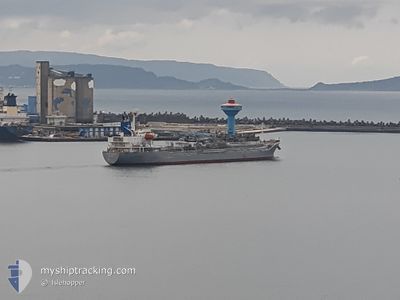
SOUTHERN HAWK
Tanker
Current Trip
JP IHA
| Time Travelled | 4 days |
|---|---|
| Remaining Time | --- |
| Distance Travelled | 834.23 nm |
| Remaining Distance | --- |
| AVG Speed | 12.1 Knots |
| MAX Speed | 14 Knots |
| AVG Wind | 6.8 knots |
| MAX Wind | 19 knots |
| MIN Temp | 27.3°C / 81.14°F |
| MAX Temp | 30.5°C / 86.9°F |
| Draught | 5.1 m |
| Position Received | 23 d ago |
Current Position
| Longitude | 134.20717° |
|---|---|
| Latitude | 34.41583° |
| Status | Under way using engine |
| Speed | 10.2 Knots |
| Course | 293° |
| Area | Inland Sea |
| Station | T-AIS |
| Position Received | 23 d ago |
Info
Information
The current position of SOUTHERN HAWK is in Inland Sea with coordinates 34.41583° / 134.20717° as reported on 2024-03-30 17:47 by AIS to our vessel tracker app. The vessel's current speed is 10.2 Knots
The vessel SOUTHERN HAWK (IMO: 9534901, MMSI: 357794000) is a Tanker It's sailing under the flag of [PA] Panama.
In this page you can find informations about the vessels current position, last detected port calls, and current voyage information. If the vessels is not in coverage by AIS you will find the latest position.
The current position of SOUTHERN HAWK is detected by our AIS receivers and we are not responsible for the reliability of the data. The last position was recorded while the vessel was in Coverage by the Ais receivers of our vessel tracking app.
The current draught of SOUTHERN HAWK as reported by AIS is 5.1 meters
Weather
| Temperature | 29.8°C / 85.64°F |
|---|---|
| Wind Speed | 5 knots |
| Direction | 17° NNE |
| Pressure | 1010.7 hPa |
| Humidity | 74.5 % |
| Cloud Coverage | 55 % |
Featured Company
Last Port Calls
| Port | Arrival | Departure | Time In Port |
|---|---|---|---|
| 2024-04-18 10:39 | 2024-04-19 14:03 | 1 d | |
| 2024-04-15 00:28 | |||
| 2024-04-02 22:57 | 2024-04-03 21:05 | 22 h | |
| 2024-04-02 22:12 | 2024-04-02 22:21 | 9 m | |
| 2024-03-28 23:08 | 2024-03-29 11:16 | 12 h | |
| 2024-03-26 22:51 | 2024-03-27 22:27 | 23 h | |
| 2024-03-18 06:16 | 2024-03-19 14:08 | 1 d | |
| 2024-03-02 02:56 | |||
| 2024-02-10 03:10 | 2024-02-10 22:10 | 19 h | |
| 2024-02-09 20:46 | 2024-02-10 02:14 | 5 h |
Last Trips
| Origin | Departure | Destination | Arrival | Distance | |
|---|---|---|---|---|---|
| 2024-04-15 08:28 | 2024-04-18 18:39 | 554.18 nm | |||
| 2024-04-03 07:21 | 2024-04-03 07:57 | 4.33 nm | |||
| 2024-03-29 20:16 | 2024-04-03 07:12 | 416.92 nm | |||
| 2024-03-28 07:27 | 2024-03-29 08:08 | 291.51 nm | |||
| 2024-03-19 22:08 | 2024-03-27 07:51 | 2143.23 nm | |||
| 2024-02-11 07:10 | 2024-03-02 11:56 | 4019.81 nm | |||
| 2024-02-10 11:14 | 2024-02-10 12:10 | 3.67 nm | |||
| 2024-02-09 17:49 | 2024-02-10 05:46 | 0.62 nm | |||
| 2024-02-08 18:58 | 2024-02-08 22:10 | 0.19 nm | |||
| 2024-02-04 11:58 | 2024-02-08 07:25 | 1018.06 nm |
Events
| Time | Event | Details | Position / Dest | Info |
|---|---|---|---|---|
| 2024-04-19 14:03 | PORT DEPARTURE |
|
5.94335 / 118.20758
JP IHA
|
Speed: Course: 57° |
| 2024-04-18 10:39 | PORT ARRIVAL |
|
5.80393 / 118.07719
[MY] SANDAKAN
|
Speed: 0.1 kn Course: 34° |
| 2024-04-16 23:42 | STOP Moving | 3.09 nm, East of SANDAKAN |
5.82565 / 118.13220
JP IHA
|
Speed: 0.1 kn Course: 225° |
| 2024-04-15 00:28 | PORT DEPARTURE |
|
9.76135 / 125.69859
JP IHA
|
Speed: 2.2 kn Course: 326° |