
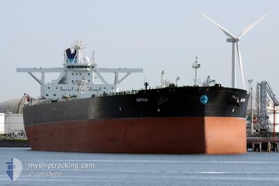
SOPHIA
Tanker
Current Trip
RONO FOR ORDERS
| Time Travelled | 23 days |
|---|---|
| Remaining Time | --- |
| Distance Travelled | 4422.12 nm |
| Remaining Distance | --- |
| AVG Speed | 11.2 Knots |
| MAX Speed | 14 Knots |
| AVG Wind | 7.1 knots |
| MAX Wind | 19 knots |
| MIN Temp | 22.2°C / 71.96°F |
| MAX Temp | 30.8°C / 87.44°F |
| Draught | 11.3 m |
| Position Received | 1 d ago |
Current Position
| Longitude | 100.22357° |
|---|---|
| Latitude | 3.67242° |
| Status | Under way using engine |
| Speed | 11.2 Knots |
| Course | 314.6° |
| Area | Malacca Strait |
| Station | T-AIS |
| Position Received | 1 d ago |
Info
Information
The current position of SOPHIA is in Malacca Strait with coordinates 3.67242° / 100.22357° as reported on 2024-04-24 02:51 by AIS to our vessel tracker app. The vessel's current speed is 11.2 Knots
The vessel SOPHIA (IMO: 9776559, MMSI: 241436000) is a Tanker It's sailing under the flag of [GR] Greece.
In this page you can find informations about the vessels current position, last detected port calls, and current voyage information. If the vessels is not in coverage by AIS you will find the latest position.
The current position of SOPHIA is detected by our AIS receivers and we are not responsible for the reliability of the data. The last position was recorded while the vessel was in Coverage by the Ais receivers of our vessel tracking app.
The current draught of SOPHIA as reported by AIS is 11.3 meters
Weather
| Temperature | 29.9°C / 85.82°F |
|---|---|
| Wind Speed | 4 knots |
| Direction | 48° NE |
| Pressure | 1007.2 hPa |
| Humidity | 73.6 % |
| Cloud Coverage | 99 % |
Featured Company
Last Port Calls
| Port | Arrival | Departure | Time In Port |
|---|---|---|---|
| 2024-03-31 10:23 | 2024-04-02 09:42 | 1 d |
Most Visited Ports (Last year)
| Port | Arrivals | |
|---|---|---|
| 2 | ||
| 2 | ||
| 2 | ||
| 1 | ||
| 1 | ||
| 1 |
Last Trips
| Origin | Departure | Destination | Arrival | Distance | |
|---|---|---|---|---|---|
| 2024-01-07 11:24 | 2024-03-31 13:23 | 14635.59 nm |
Events
| Time | Event | Details | Position / Dest | Info |
|---|---|---|---|---|
| 2024-04-24 02:55 | Status Changed | Default Under way using engine |
3.68176 / 100.21426
RONO FOR ORDERS
|
Speed: 11.2 kn Course: 314.6° |
| 2024-04-24 02:51 | OUT of Coverage |
3.67242 / 100.22357
Malacca Strait
RONO FOR ORDERS
|
Speed: 11.2 kn Course: 314.6° |
|
| 2024-04-24 02:38 | Status Changed | Under way using engine Default |
3.64439 / 100.25116
RONO FOR ORDERS
|
Speed: 11.3 kn Course: 323° |
| 2024-04-24 02:24 | Status Changed | Default Under way using engine |
3.61048 / 100.27758
RONO FOR ORDERS
|
Speed: 11.3 kn Course: 316.8° |
| 2024-04-24 01:16 | Status Changed | Under way using engine Default |
3.45745 / 100.42807
RONO FOR ORDERS
|
Speed: 11.3 kn Course: 324° |
| 2024-04-24 01:03 | Status Changed | Default Under way using engine |
3.42477 / 100.45133
RONO FOR ORDERS
|
Speed: 11.4 kn Course: 323.2° |
| 2024-04-24 00:36 | Status Changed | Under way using engine Default |
3.36064 / 100.51496
RONO FOR ORDERS
|
Speed: 12.1 kn Course: 317° |
| 2024-04-24 00:28 | Status Changed | Default Under way using engine |
3.34103 / 100.53347
RONO FOR ORDERS
|
Speed: 12.1 kn Course: 317.4° |
| 2024-04-24 00:22 | Status Changed | Under way using engine Default |
3.32660 / 100.54694
RONO FOR ORDERS
|
Speed: 12.2 kn Course: 316° |
| 2024-04-24 00:18 | Status Changed | Default Under way using engine |
3.31721 / 100.55594
RONO FOR ORDERS
|
Speed: 12.2 kn Course: 315.6° |