
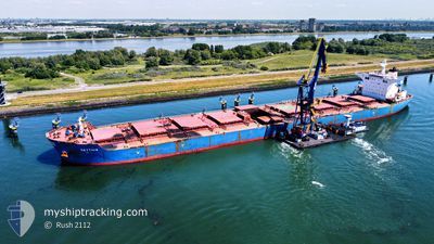
SKYTHIA
Bulk Carrier
Current Trip
| Time Travelled | 10 days |
|---|---|
| Remaining Time | --- |
| Distance Travelled | 2333.66 nm |
| Remaining Distance | --- |
| AVG Speed | 9.5 Knots |
| MAX Speed | 12.6 Knots |
| AVG Wind | 9.3 knots |
| MAX Wind | 20 knots |
| MIN Temp | 27.1°C / 80.78°F |
| MAX Temp | 30.6°C / 87.08°F |
| Draught | 18.3 m |
| Position Received | 9 d ago |
Current Position
| Longitude | 118.35455° |
|---|---|
| Latitude | -19.51378° |
| Status | Under way using engine |
| Speed | 4.9 Knots |
| Course | 348° |
| Area | Indian Ocean |
| Station | T-AIS |
| Position Received | 9 d ago |
Info
Information
The current position of SKYTHIA is in Indian Ocean with coordinates -19.51378° / 118.35455° as reported on 2024-04-14 12:02 by AIS to our vessel tracker app. The vessel's current speed is 4.9 Knots and is heading at the port of QINGDAO. The estimated time of arrival as calculated by MyShipTracking vessel tracking app is 2024-04-27 05:30 LT
The vessel SKYTHIA (IMO: 9423920, MMSI: 248087000) is a Bulk Carrier that was built in 2010 ( 14 years old ). It's sailing under the flag of [MT] Malta.
In this page you can find informations about the vessels current position, last detected port calls, and current voyage information. If the vessels is not in coverage by AIS you will find the latest position.
The current position of SKYTHIA is detected by our AIS receivers and we are not responsible for the reliability of the data. The last position was recorded while the vessel was in Coverage by the Ais receivers of our vessel tracking app.
The current draught of SKYTHIA as reported by AIS is 18.3 meters
Weather
| Temperature | 29.8°C / 85.64°F |
|---|---|
| Wind Speed | 5 knots |
| Direction | 127° SE |
| Pressure | 1007.6 hPa |
| Humidity | 72.7 % |
| Cloud Coverage | 6 % |
Featured Company
Last Port Calls
| Port | Arrival | Departure | Time In Port |
|---|---|---|---|
| 2024-04-13 06:20 | 2024-04-14 06:18 | 23 h | |
| 2024-03-26 10:36 | 2024-03-28 21:07 | 2 d |
Last Trips
| Origin | Departure | Destination | Arrival | Distance | |
|---|---|---|---|---|---|
| 2024-03-29 05:07 | 2024-04-13 14:20 | 3591.43 nm |
Events
| Time | Event | Details | Position / Dest | Info |
|---|---|---|---|---|
| 2024-04-14 12:05 | Status Changed | Default Under way using engine |
-19.50884 / 118.35327
QINGDAO
|
Speed: 4.9 kn Course: 348° |
| 2024-04-14 12:02 | Status Changed | Under way using engine Default |
-19.51378 / 118.35455
QINGDAO
|
Speed: 3 kn Course: -1° |
| 2024-04-14 12:02 | OUT of Coverage |
-19.51378 / 118.35455
Indian Ocean
QINGDAO
|
Speed: 4.9 kn Course: 346.1° |
|
| 2024-04-14 12:00 | Status Changed | Default Under way using engine |
-19.51667 / 118.35500
QINGDAO
|
Speed: 2.4 kn Course: 344° |
| 2024-04-14 11:52 | Status Changed | Under way using engine Default |
-19.52264 / 118.35729
QINGDAO
|
Speed: 2.9 kn Course: 5° |
| 2024-04-14 11:36 | Status Changed | Default Under way using engine |
-19.53686 / 118.35922
QINGDAO
|
Speed: 3.8 kn Course: 347° |
| 2024-04-14 11:17 | Status Changed | Under way using engine Default |
-19.56219 / 118.36659
QINGDAO
|
Speed: 10.3 kn Course: 345° |
| 2024-04-14 11:00 | Status Changed | Default Under way using engine |
-19.59879 / 118.37645
QINGDAO
|
Speed: 10.3 kn Course: 345.9° |
| 2024-04-14 10:37 | Status Changed | Under way using engine Default |
-19.66324 / 118.39387
QINGDAO
|
Speed: 10 kn Course: 344° |
| 2024-04-14 10:24 | IN Coverage |
-19.65709 / 118.39214
Indian Ocean
QINGDAO
|
Speed: 10.4 kn Course: 344.5° |