
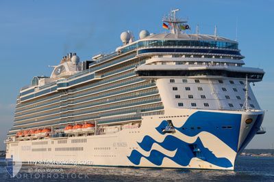
SKY PRINCESS
Passenger
Current Trip
| Trip Time | 1 day |
|---|---|
| Trip Distance | 722.99 nm |
| AVG Speed | 16.9 Knots |
| MAX Speed | 22.3 Knots |
| Draught | 8.6 m |
| AVG Wind | 14 knots |
| MAX Wind | 21.9 knots |
| MIN Temp | 12.5°C / 54.5°F |
| MAX Temp | 18.8°C / 65.84°F |
| Position Received | Now |
Current Position
| Longitude | -8.72723° |
|---|---|
| Latitude | 42.24272° |
| Status | Under way using engine |
| Speed | |
| Course | 54° |
| Area | North Atlantic Ocean |
| Station | T-AIS |
| Position Received | Now |
Info
Information
The current position of SKY PRINCESS is in North Atlantic Ocean with coordinates 42.24272° / -8.72723° as reported on 2024-04-25 15:10 by AIS to our vessel tracker app. The vessel's current speed is 0 Knots and is currently inside the port of VIGO.
The vessel SKY PRINCESS (IMO: 9802396, MMSI: 310780000) is a Passenger It's sailing under the flag of [BM] Bermuda.
In this page you can find informations about the vessels current position, last detected port calls, and current voyage information. If the vessels is not in coverage by AIS you will find the latest position.
The current position of SKY PRINCESS is detected by our AIS receivers and we are not responsible for the reliability of the data. The last position was recorded while the vessel was in Coverage by the Ais receivers of our vessel tracking app.
The current draught of SKY PRINCESS as reported by AIS is 8.6 meters
Weather
| Temperature | 13.4°C / 56.12°F |
|---|---|
| Wind Speed | 9 knots |
| Direction | 290° WNW |
| Pressure | 1012 hPa |
| Humidity | 76.7 % |
| Cloud Coverage | 39 % |
Featured Company
Last Port Calls
| Port | Arrival | Departure | Time In Port |
|---|---|---|---|
| 2024-04-25 12:30 | |||
| 2024-04-23 07:02 | 2024-04-23 18:29 | 11 h | |
| 2024-04-22 04:16 | 2024-04-22 16:17 | 12 h | |
| 2024-04-21 06:03 | 2024-04-21 21:18 | 15 h | |
| 2024-04-20 05:54 | 2024-04-20 20:54 | 15 h | |
| 2024-04-18 06:06 | 2024-04-18 16:35 | 10 h | |
| 2024-04-15 04:29 | 2024-04-15 15:28 | 10 h | |
| 2024-04-14 05:08 | 2024-04-14 16:00 | 10 h | |
| 2024-04-11 04:40 | 2024-04-11 16:07 | 11 h | |
| 2024-04-10 04:40 | 2024-04-10 14:21 | 9 h |
Most Visited Ports (Last year)
| Port | Arrivals | |
|---|---|---|
| 20 | ||
| 16 | ||
| 9 | ||
| 8 | ||
| 6 | ||
| 6 |
Last Trips
| Origin | Departure | Destination | Arrival | Distance | |
|---|---|---|---|---|---|
| 2024-04-23 19:29 | 2024-04-25 14:30 | 722.99 nm | |||
| 2024-04-22 17:17 | 2024-04-23 08:02 | 293.53 nm | |||
| 2024-04-21 22:18 | 2024-04-22 05:16 | 125.67 nm | |||
| 2024-04-20 21:54 | 2024-04-21 07:03 | 119.76 nm | |||
| 2024-04-18 17:35 | 2024-04-20 06:54 | 636.33 nm | |||
| 2024-04-15 16:28 | 2024-04-18 07:06 | 956.66 nm | |||
| 2024-04-14 18:00 | 2024-04-15 05:29 | 122.95 nm | |||
| 2024-04-11 18:07 | 2024-04-14 07:08 | 628.90 nm | |||
| 2024-04-10 16:21 | 2024-04-11 06:40 | 261.81 nm | |||
| 2024-04-08 16:30 | 2024-04-10 06:40 | 594.50 nm |
Events
| Time | Event | Details | Position / Dest | Info |
|---|---|---|---|---|
| 2024-04-25 12:39 | STOP Moving |
42.24282 / -8.72744
[ES] VIGO
|
Speed: 0.3 kn Course: 56° |
|
| 2024-04-25 12:39 | Destination Changed | GB SOU ES VGO |
42.24283 / -8.72750
[ES] VIGO
|
Speed: 0.4 kn Course: 57° |
| 2024-04-25 12:39 | ETA Changed | 2024/04/27 02:15 2024/04/25 12:15 |
42.24283 / -8.72750
[ES] VIGO
|
Speed: 0.4 kn Course: 57° |
| 2024-04-25 12:30 | PORT ARRIVAL |
|
42.24254 / -8.73360
[ES] VIGO
|
Speed: 4.1 kn Course: 82° |
| 2024-04-25 11:55 | Destination Changed | ES VGO GB SOU |
42.17531 / -8.86722
ES VGO
|
Speed: 21.4 kn Course: 43° |
| 2024-04-25 11:55 | ETA Changed | 2024/04/25 12:15 2024/04/27 02:15 |
42.17531 / -8.86722
ES VGO
|
Speed: 21.4 kn Course: 43° |
| 2024-04-25 11:20 | Change Sea Area | Spanish part of the North Atlantic Ocean Portuguese part of the North Atlantic Ocean |
42.03721 / -9.06426
North Atlantic Ocean
GB SOU
|
Speed: 21.4 kn Course: 37.7° |
| 2024-04-25 11:20 | Status Changed | Under way using engine Default |
42.03721 / -9.06426
GB SOU
|
Speed: 21.4 kn Course: 38° |
| 2024-04-25 11:10 | IN Coverage |
42.03721 / -9.06426
North Atlantic Ocean
GB SOU
|
Speed: 21.4 kn Course: 37.7° |
|
| 2024-04-25 02:59 | OUT of Coverage |
40.15194 / -11.53436
North Atlantic Ocean
GB SOU
|
Speed: 16.4 kn Course: 26.3° |