
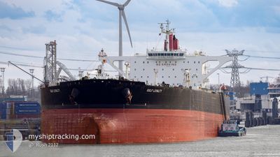
GULF LOYALTY
Crude Oil Tanker
Current Trip
FOR ORDERS
| Time Travelled | 17 days |
|---|---|
| Remaining Time | --- |
| Distance Travelled | 353.34 nm |
| Remaining Distance | --- |
| AVG Speed | 6.1 Knots |
| MAX Speed | 17.6 Knots |
| AVG Wind | 18.1 knots |
| MAX Wind | 43.6 knots |
| MIN Temp | 7.5°C / 45.5°F |
| MAX Temp | 13.2°C / 55.76°F |
| Draught | 11 m |
| Position Received | 1 m ago |
Current Position
| Longitude | -4.98865° |
|---|---|
| Latitude | 49.91067° |
| Status | Under way using engine |
| Speed | 10.5 Knots |
| Course | 198.6° |
| Area | English Channel |
| Station | T-AIS |
| Position Received | 1 m ago |
Info
Information
The current position of GULF LOYALTY is in English Channel with coordinates 49.91067° / -4.98865° as reported on 2024-04-25 20:33 by AIS to our vessel tracker app. The vessel's current speed is 10.5 Knots
The vessel GULF LOYALTY (IMO: 9441245, MMSI: 538004634) is a Crude Oil Tanker that was built in 2011 ( 13 years old ). It's sailing under the flag of [MH] Marshall Is.
In this page you can find informations about the vessels current position, last detected port calls, and current voyage information. If the vessels is not in coverage by AIS you will find the latest position.
The current position of GULF LOYALTY is detected by our AIS receivers and we are not responsible for the reliability of the data. The last position was recorded while the vessel was in Coverage by the Ais receivers of our vessel tracking app.
The current draught of GULF LOYALTY as reported by AIS is 11 meters
Weather
| Temperature | 9.6°C / 49.28°F |
|---|---|
| Wind Speed | 6 knots |
| Direction | 306° NW |
| Pressure | 1003.1 hPa |
| Humidity | 80 % |
| Cloud Coverage | 100 % |
Featured Company
Last Port Calls
| Port | Arrival | Departure | Time In Port |
|---|---|---|---|
| 2024-04-03 06:48 | 2024-04-08 08:45 | 5 d | |
| 2024-03-31 13:56 | 2024-04-03 06:12 | 2 d | |
| 2024-03-28 14:05 | 2024-03-30 04:06 | 1 d | |
| 2024-03-27 05:50 | 2024-03-28 13:37 | 1 d | |
| 2024-03-25 17:19 | 2024-03-27 05:22 | 1 d | |
| 2024-02-27 17:09 | 2024-02-29 15:11 | 1 d |
Most Visited Ports (Last year)
| Port | Arrivals | |
|---|---|---|
| 2 | ||
| 2 | ||
| 1 | ||
| 1 | ||
| 1 | ||
| 1 |
Last Trips
| Origin | Departure | Destination | Arrival | Distance | |
|---|---|---|---|---|---|
| 2024-04-03 07:12 | 2024-04-03 07:48 | 3.04 nm | |||
| 2024-03-30 05:06 | 2024-03-31 14:56 | 269.93 nm | |||
| 2024-03-28 14:37 | 2024-03-28 15:05 | 1.82 nm | |||
| 2024-03-27 06:22 | 2024-03-27 06:50 | 1.68 nm | |||
| 2024-02-29 09:11 | 2024-03-25 18:19 | 5441.21 nm |
Events
| Time | Event | Details | Position / Dest | Info |
|---|---|---|---|---|
| 2024-04-25 18:58 | START Moving | 2.19 nm, South of FALMOUTH |
50.12183 / -5.05954
FOR ORDERS
|
Speed: 3.8 kn Course: 39° |
| 2024-04-25 18:51 | Status Changed | Under way using engine At anchor |
50.11850 / -5.05734
FOR ORDERS
|
Speed: 0.6 kn Course: 315° |
| 2024-04-25 18:46 | Destination Changed | FOR ORDERS GB FAL |
50.11930 / -5.05838
FOR ORDERS
|
Speed: 0.1 kn Course: 298° |
| 2024-04-25 18:46 | ETA Changed | 2024/04/25 07:07 2024/04/09 07:07 |
50.11930 / -5.05838
FOR ORDERS
|
Speed: 0.1 kn Course: 298° |
| 2024-04-25 16:47 | Status Changed | At anchor Default |
50.11875 / -5.05616
GB FAL
|
Speed: Course: 283° |
| 2024-04-25 16:38 | Status Changed | Default At anchor |
50.11873 / -5.05602
GB FAL
|
Speed: 0.1 kn Course: 283° |
| 2024-04-25 16:29 | Status Changed | At anchor Default |
50.11876 / -5.05610
GB FAL
|
Speed: 0.1 kn Course: 279° |
| 2024-04-25 16:08 | Status Changed | Default At anchor |
50.11833 / -5.05667
GB FAL
|
Speed: 0.1 kn Course: 281° |
| 2024-04-25 15:35 | Status Changed | At anchor Default |
50.11864 / -5.05599
GB FAL
|
Speed: 0.1 kn Course: 287° |
| 2024-04-25 15:32 | Status Changed | Default At anchor |
50.11860 / -5.05598
GB FAL
|
Speed: 0.1 kn Course: 288° |