
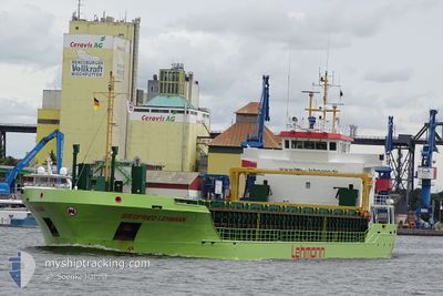
SIEGFRIED LEHMANN
General Cargo
Current Trip
| Time Travelled | 4 days |
|---|---|
| Remaining Time | 1 day |
| Distance Travelled | 900.24 nm |
| Remaining Distance | 282.25 nm |
| AVG Speed | 9.5 Knots |
| MAX Speed | 13 Knots |
| AVG Wind | 16.2 knots |
| MAX Wind | 27.9 knots |
| MIN Temp | 1.4°C / 34.52°F |
| MAX Temp | 12.5°C / 54.5°F |
| Draught | 5.4 m |
| Position Received | 1 m ago |
Current Position
| Longitude | 16.20974° |
|---|---|
| Latitude | 55.97320° |
| Status | Under way using engine |
| Speed | 10.4 Knots |
| Course | 242.1° |
| Area | Baltic Sea |
| Station | T-AIS |
| Position Received | 1 m ago |
Info
Information
The current position of SIEGFRIED LEHMANN is in Baltic Sea with coordinates 55.97320° / 16.20974° as reported on 2024-04-18 05:05 by AIS to our vessel tracker app. The vessel's current speed is 10.4 Knots and is heading at the port of RANDERS. The estimated time of arrival as calculated by MyShipTracking vessel tracking app is 2024-04-19 08:08 LT
The vessel SIEGFRIED LEHMANN (IMO: 9325142, MMSI: 305982000) is a General Cargo that was built in 2005 ( 19 years old ). It's sailing under the flag of [AG] Antigua Barbuda.
In this page you can find informations about the vessels current position, last detected port calls, and current voyage information. If the vessels is not in coverage by AIS you will find the latest position.
The current position of SIEGFRIED LEHMANN is detected by our AIS receivers and we are not responsible for the reliability of the data. The last position was recorded while the vessel was in Coverage by the Ais receivers of our vessel tracking app.
The current draught of SIEGFRIED LEHMANN as reported by AIS is 5.4 meters
Weather
| Temperature | 3.1°C / 37.58°F |
|---|---|
| Wind Speed | 5 knots |
| Direction | 35° NE |
| Pressure | 1013 hPa |
| Humidity | 79.5 % |
| Cloud Coverage | 12 % |
Featured Company
Last Port Calls
| Port | Arrival | Departure | Time In Port |
|---|---|---|---|
| 2024-04-10 19:47 | 2024-04-13 17:14 | 2 d | |
| 2024-03-31 00:55 | 2024-04-05 08:35 | 5 d | |
| 2024-03-26 05:01 | 2024-03-27 14:02 | 1 d | |
| 2024-03-24 00:27 | 2024-03-25 00:16 | 23 h | |
| 2024-03-17 01:33 | 2024-03-19 13:46 | 2 d | |
| 2024-03-14 22:05 | 2024-03-15 21:54 | 23 h | |
| 2024-03-07 22:24 | 2024-03-08 22:03 | 23 h | |
| 2024-03-04 22:22 | 2024-03-04 23:00 | 38 m | |
| 2024-03-02 15:48 | 2024-03-04 17:13 | 2 d | |
| 2024-03-02 10:28 | 2024-03-02 10:48 | 19 m |
Last Trips
| Origin | Departure | Destination | Arrival | Distance | |
|---|---|---|---|---|---|
| 2024-04-05 10:35 | 2024-04-10 21:47 | 1090.15 nm | |||
| 2024-03-27 16:02 | 2024-03-31 01:55 | 563.39 nm | |||
| 2024-03-25 01:16 | 2024-03-26 07:01 | 263.63 nm | |||
| 2024-03-19 13:46 | 2024-03-24 01:27 | 899.77 nm | |||
| 2024-03-15 22:54 | 2024-03-17 01:33 | 169.00 nm | |||
| 2024-03-09 00:03 | 2024-03-14 23:05 | 1017.29 nm | |||
| 2024-03-05 00:00 | 2024-03-08 00:24 | 523.56 nm | |||
| 2024-03-04 18:13 | 2024-03-04 23:22 | 34.98 nm | |||
| 2024-03-02 11:48 | 2024-03-02 16:48 | 48.44 nm | |||
| 2024-02-23 16:13 | 2024-03-02 11:28 | 1329.09 nm |
Events
| Time | Event | Details | Position / Dest | Info |
|---|---|---|---|---|
| 2024-04-18 04:01 | Draught Changed | 5.4 3.9 |
56.06077 / 16.50474
RANDERS
|
Speed: 10.4 kn Course: 243.1° |
| 2024-04-18 04:01 | Destination Changed | RANDERS RIGA |
56.06077 / 16.50474
RANDERS
|
Speed: 10.4 kn Course: 243.1° |
| 2024-04-18 04:01 | ETA Changed | 2024/04/19 08:00 2024/04/16 01:00 |
56.06077 / 16.50474
RANDERS
|
Speed: 10.4 kn Course: 243.1° |
| 2024-04-18 03:39 | Status Changed | Under way using engine Default |
56.09469 / 16.59728
RIGA
|
Speed: 10.4 kn Course: 233° |
| 2024-04-18 03:37 | IN Coverage |
56.09171 / 16.59047
Baltic Sea
|
Speed: 10.4 kn Course: 232.1° |
|
| 2024-04-16 22:48 | START Moving | 5.11 nm, North of RIGA |
57.03281 / 24.08004
RIGA
|
Speed: 9.7 kn Course: 330° |
| 2024-04-16 01:35 | STOP Moving | 4.6 nm, North of RIGA |
57.02446 / 24.08428
RIGA
|
Speed: Course: 343° |
| 2024-04-14 22:06 | Status Changed | Default Under way using engine |
56.08036 / 16.79505
RIGA
|
Speed: 10.4 kn Course: 50.7° |
| 2024-04-14 22:00 | OUT of Coverage |
56.06908 / 16.76769
Baltic Sea
RIGA
|
Speed: 10.4 kn Course: 50.7° |
|
| 2024-04-14 17:01 | Change Sea Area | Swedish part of the Baltic Sea Danish part of the Kattegat |
55.61209 / 15.40897
Baltic Sea
RIGA
|
Speed: 10.9 kn Course: 58.8° |