
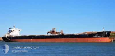
SG EXPRESS
Bulk Carrier
Current Trip
| Time Travelled | 10 days |
|---|---|
| Remaining Time | --- |
| Distance Travelled | 1252.30 nm |
| Remaining Distance | --- |
| AVG Speed | 9.3 Knots |
| MAX Speed | 12.3 Knots |
| AVG Wind | 17.6 knots |
| MAX Wind | 29 knots |
| MIN Temp | 12°C / 53.6°F |
| MAX Temp | 24.9°C / 76.82°F |
| Draught | 17.7 m |
| Position Received | 2024-11-11 14:26 |
Current Position
| Longitude | --- |
|---|---|
| Latitude | --- |
| Status | Under way using engine |
| Speed | 11.2 Knots |
| Course | 349.6° |
| Area | Indian Ocean |
| Station | T-AIS |
| Position Received | 2024-11-11 14:26 |
Info
Information
The current position of SG EXPRESS is in Indian Ocean with coordinates -15.00103° / 116.60798° as reported on 2024-11-11 14:26 by AIS to our vessel tracker app. The vessel's current speed is 11.2 Knots
The vessel SG EXPRESS (IMO: 9483310, MMSI: 351772000) is a Bulk Carrier that was built in 2009 ( 15 years old ). It's sailing under the flag of [PA] Panama.
In this page you can find informations about the vessels current position, last detected port calls, and current voyage information. If the vessels is not in coverage by AIS you will find the latest position.
The current position of SG EXPRESS is detected by our AIS receivers and we are not responsible for the reliability of the data. The last position was recorded while the vessel was in Coverage by the Ais receivers of our vessel tracking app.
The current draught of SG EXPRESS as reported by AIS is 17.7 meters
Weather
| Temperature | 11.3°C / 52.34°F |
|---|---|
| Wind Speed | 16 knots |
| Direction | 27° NNE |
| Pressure | 1025.5 hPa |
| Humidity | 63 % |
| Cloud Coverage | 100 % |
Featured Company
Last Port Calls
| Port | Arrival | Departure | Time In Port |
|---|---|---|---|
| 2024-11-30 12:02 | 2024-12-03 03:04 | 2 d | |
| 2024-11-08 07:29 | 2024-11-10 06:45 | 1 d | |
| 2024-10-18 09:37 | 2024-10-22 07:18 | 3 d | |
| 2024-10-02 04:00 | 2024-10-04 02:20 | 1 d |
Most Visited Ports (Last year)
| Port | Arrivals | |
|---|---|---|
| 4 | ||
| 2 | ||
| 1 | ||
| 1 | ||
| 1 | ||
| 1 |
Last Trips
| Origin | Departure | Destination | Arrival | Distance | |
|---|---|---|---|---|---|
| 2024-11-10 14:45 | 2024-11-30 18:02 | 2842.74 nm | |||
| 2024-10-22 15:18 | 2024-11-08 15:29 | 3622.25 nm | |||
| 2024-10-04 10:20 | 2024-10-18 17:37 | 3604.87 nm | |||
| 2024-09-17 16:40 | 2024-10-02 12:00 | 3429.45 nm |
Events
| Time | Event | Details | Position / Dest | Info |
|---|---|---|---|---|
| 2024-12-10 06:33 | STOP Moving | 9.28 nm, West of JINHAI HEAVY INDUSTR |
30.28490 / 122.07440
QINGDAO CN
|
Speed: Course: 290° |
| 2024-12-09 23:53 | START Moving |
29.92706 / 122.78763
QINGDAO CN
|
Speed: 3.6 kn Course: 290° |
|
| 2024-12-08 10:10 | STOP Moving |
29.92132 / 122.79288
QINGDAO CN
|
Speed: 0.2 kn Course: 357° |