
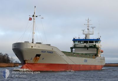
SCOT PIONEER
General Cargo
Current Trip
| Time Travelled | 2 days |
|---|---|
| Remaining Time | 12 h, 57 mins |
| Distance Travelled | 783.98 nm |
| Remaining Distance | 149.66 nm |
| AVG Speed | 11.9 Knots |
| MAX Speed | 16 Knots |
| AVG Wind | 10.3 knots |
| MAX Wind | 20.1 knots |
| MIN Temp | 4.1°C / 39.38°F |
| MAX Temp | 13.9°C / 57.02°F |
| Draught | 4.7 m |
| Position Received | 1 m ago |
Current Position
| Longitude | 11.37911° |
|---|---|
| Latitude | 57.49540° |
| Status | Under way using engine |
| Speed | 11.1 Knots |
| Course | 138.7° |
| Area | Kattegat |
| Station | T-AIS |
| Position Received | 1 m ago |
Info
Information
The current position of SCOT PIONEER is in Kattegat with coordinates 57.49540° / 11.37911° as reported on 2024-04-23 10:55 by AIS to our vessel tracker app. The vessel's current speed is 11.1 Knots and is heading at the port of KOEGE. The estimated time of arrival as calculated by MyShipTracking vessel tracking app is 2024-04-23 23:53 LT
The vessel SCOT PIONEER (IMO: 9331347, MMSI: 235060914) is a General Cargo that was built in 2006 ( 18 years old ). It's sailing under the flag of [GB] United Kingdom.
In this page you can find informations about the vessels current position, last detected port calls, and current voyage information. If the vessels is not in coverage by AIS you will find the latest position.
The current position of SCOT PIONEER is detected by our AIS receivers and we are not responsible for the reliability of the data. The last position was recorded while the vessel was in Coverage by the Ais receivers of our vessel tracking app.
The current draught of SCOT PIONEER as reported by AIS is 4.7 meters
Weather
| Temperature | 5.1°C / 41.18°F |
|---|---|
| Wind Speed | 15 knots |
| Direction | 196° SSW |
| Pressure | 1013 hPa |
| Humidity | 83 % |
| Cloud Coverage | 100 % |
Featured Company
Last Port Calls
| Port | Arrival | Departure | Time In Port |
|---|---|---|---|
| 2024-04-18 21:17 | 2024-04-20 15:54 | 1 d | |
| 2024-04-17 02:26 | 2024-04-17 17:22 | 14 h | |
| 2024-04-16 10:49 | 2024-04-16 19:49 | 9 h | |
| 2024-04-09 13:26 | 2024-04-12 14:36 | 3 d | |
| 2024-04-01 09:25 | 2024-04-03 15:46 | 2 d | |
| 2024-03-29 09:07 | 2024-03-30 10:52 | 1 d | |
| 2024-03-25 12:11 | 2024-03-29 00:43 | 3 d | |
| 2024-03-23 05:52 | 2024-03-23 14:01 | 8 h | |
| 2024-03-21 08:50 | 2024-03-22 21:27 | 1 d | |
| 2024-03-14 13:42 | 2024-03-15 12:06 | 22 h |
Last Trips
| Origin | Departure | Destination | Arrival | Distance | |
|---|---|---|---|---|---|
| 2024-04-17 18:22 | 2024-04-18 22:17 | 106.11 nm | |||
| 2024-04-16 20:49 | 2024-04-17 03:26 | 77.43 nm | |||
| 2024-04-12 16:36 | 2024-04-16 11:49 | 940.50 nm | |||
| 2024-04-03 17:46 | 2024-04-09 15:26 | 1225.95 nm | |||
| 2024-03-30 10:52 | 2024-04-01 11:25 | 530.84 nm | |||
| 2024-03-29 00:43 | 2024-03-29 09:07 | 100.89 nm | |||
| 2024-03-23 14:01 | 2024-03-25 12:11 | 432.81 nm | |||
| 2024-03-22 21:27 | 2024-03-23 05:52 | 76.69 nm | |||
| 2024-03-15 13:06 | 2024-03-21 08:50 | 1573.94 nm | |||
| 2024-03-11 14:53 | 2024-03-14 14:42 | 799.66 nm |
Events
| Time | Event | Details | Position / Dest | Info |
|---|---|---|---|---|
| 2024-04-23 10:43 | Detected in Sea | Swedish part of the Kattegat |
57.52240 / 11.33177
Kattegat
KOGE
|
Speed: 11.2 kn Course: 136.8° |
| 2024-04-23 08:52 | Change Sea Area | Danish part of the Kattegat Danish part of the Skaggerak |
57.78013 / 10.87401
Kattegat
KOGE
|
Speed: 12.2 kn Course: 126.4° |
| 2024-04-23 05:24 | ETA Changed | 2024/04/24 02:00 2024/04/24 03:00 |
57.76843 / 9.55995
KOGE
|
Speed: 12.1 kn Course: 86.3° |
| 2024-04-23 03:47 | Change Sea Area | Danish part of the Skaggerak Norwegian part of the Skaggerak |
57.72554 / 8.94370
Skaggerak
KOGE
|
Speed: 12.5 kn Course: 83.1° |
| 2024-04-22 23:53 | Change Sea Area | Norwegian part of the Skaggerak Norwegian part of the North Sea |
57.69285 / 7.55796
Skaggerak
KOGE
|
Speed: 11.4 kn Course: 94.2° |
| 2024-04-22 18:38 | ETA Changed | 2024/04/24 03:00 2024/04/24 06:00 |
57.85484 / 5.72990
KOGE
|
Speed: 12.7 kn Course: 104.7° |
| 2024-04-22 11:24 | Status Changed | Under way using engine Default |
58.18542 / 2.97932
KOGE
|
Speed: 12 kn Course: 102° |
| 2024-04-22 11:13 | Status Changed | Default Under way using engine |
58.19333 / 2.90667
KOGE
|
Speed: 12.1 kn Course: 103.5° |
| 2024-04-22 11:05 | Detected in Sea | Norwegian part of the North Sea |
58.19983 / 2.85982
North Sea
KOGE
|
Speed: 12.1 kn Course: 103.5° |
| 2024-04-22 11:05 | Status Changed | Under way using engine Default |
58.19983 / 2.85982
KOGE
|
Speed: 12 kn Course: 103° |