
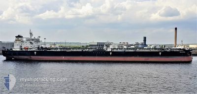
SALAMINA
Crude Oil Tanker
Current Trip
| Time Travelled | 2 days |
|---|---|
| Remaining Time | --- |
| Distance Travelled | 736.01 nm |
| Remaining Distance | --- |
| AVG Speed | 13.8 Knots |
| MAX Speed | 15.6 Knots |
| AVG Wind | 9.9 knots |
| MAX Wind | 16.3 knots |
| MIN Temp | 14.2°C / 57.56°F |
| MAX Temp | 18.4°C / 65.12°F |
| Draught | 8 m |
| Position Received | 1 d ago |
Current Position
| Longitude | -117.62910° |
|---|---|
| Latitude | 32.10309° |
| Status | Under way using engine |
| Speed | 15.1 Knots |
| Course | 162.5° |
| Area | North Pacific Ocean |
| Station | T-AIS |
| Position Received | 1 d ago |
Info
Information
The current position of SALAMINA is in North Pacific Ocean with coordinates 32.10309° / -117.62910° as reported on 2024-04-23 01:04 by AIS to our vessel tracker app. The vessel's current speed is 15.1 Knots and is heading at the port of SALINA CRUZ. The estimated time of arrival as calculated by MyShipTracking vessel tracking app is 2024-04-27 23:00 LT
The vessel SALAMINA (IMO: 9382968, MMSI: 636014128) is a Crude Oil Tanker that was built in 2009 ( 15 years old ). It's sailing under the flag of [LR] Liberia.
In this page you can find informations about the vessels current position, last detected port calls, and current voyage information. If the vessels is not in coverage by AIS you will find the latest position.
The current position of SALAMINA is detected by our AIS receivers and we are not responsible for the reliability of the data. The last position was recorded while the vessel was in Coverage by the Ais receivers of our vessel tracking app.
The current draught of SALAMINA as reported by AIS is 8 meters
Weather
| Temperature | 18.4°C / 65.12°F |
|---|---|
| Wind Speed | 14 knots |
| Direction | 336° NNW |
| Pressure | 1016.9 hPa |
| Humidity | 82.5 % |
| Cloud Coverage | 62 % |
Featured Company
Last Port Calls
| Port | Arrival | Departure | Time In Port |
|---|---|---|---|
| 2024-04-22 04:14 | 2024-04-22 16:59 | 12 h | |
| 2024-03-30 13:52 | 2024-04-04 11:34 | 4 d | |
| 2024-03-28 05:27 | 2024-03-29 12:51 | 1 d | |
| 2024-03-22 14:31 | 2024-03-24 01:44 | 1 d | |
| 2024-03-10 22:15 | |||
| 2024-02-02 16:14 | 2024-03-01 20:27 | 28 d |
Most Visited Ports (Last year)
| Port | Arrivals | |
|---|---|---|
| 2 | ||
| 2 | ||
| 2 | ||
| 2 | ||
| 2 | ||
| 1 |
Last Trips
| Origin | Departure | Destination | Arrival | Distance | |
|---|---|---|---|---|---|
| 2024-04-04 05:34 | 2024-04-21 21:14 | 2423.15 nm | |||
| 2024-03-29 06:51 | 2024-03-30 07:52 | 190.16 nm | |||
| 2024-03-23 20:44 | 2024-03-27 23:27 | 1317.08 nm | |||
| 2024-03-01 15:27 | 2024-03-22 09:31 | 3241.53 nm | |||
| 2024-03-01 15:27 | 2024-03-10 16:15 | 1477.09 nm | |||
| 2023-11-14 18:08 | 2024-02-02 11:14 | 1477.31 nm |
Events
| Time | Event | Details | Position / Dest | Info |
|---|---|---|---|---|
| 2024-04-23 01:10 | Status Changed | Default Under way using engine |
32.07935 / -117.62041
US LGB > MX SCX
|
Speed: 15.1 kn Course: 162.5° |
| 2024-04-23 01:04 | OUT of Coverage |
32.10309 / -117.62910
North Pacific Ocean
US LGB > MX SCX
|
Speed: 15.1 kn Course: 162.5° |
|
| 2024-04-22 22:32 | Change Sea Area | Mexican part of the North Pacific Ocean United States part of the North Pacific Ocean |
32.62365 / -117.82053
North Pacific Ocean
US LGB > MX SCX
|
Speed: 14.5 kn Course: 162.6° |
| 2024-04-22 17:58 | ETA Changed | 2024/04/27 23:00 2024/04/28 06:00 |
33.54799 / -118.20336
US LGB > MX SCX
|
Speed: 11.7 kn Course: 161.7° |
| 2024-04-22 17:51 | ETA Changed | 2024/04/28 06:00 2024/04/27 23:00 |
33.56940 / -118.21226
US LGB > MX SCX
|
Speed: 11.8 kn Course: 161.1° |
| 2024-04-22 16:59 | PORT DEPARTURE |
|
33.71946 / -118.18603
US LGB > MX SCX
|
Speed: 8.7 kn Course: 195° |
| 2024-04-22 16:58 | ETA Changed | 2024/04/27 23:00 2024/04/28 01:00 |
33.72177 / -118.18515
[US] LOS ANGELES
|
Speed: 8.3 kn Course: 195° |
| 2024-04-22 16:51 | ETA Changed | 2024/04/28 01:00 2024/04/22 04:00 |
33.72905 / -118.20006
[US] LOS ANGELES
|
Speed: 9.2 kn Course: 79° |
| 2024-04-22 16:45 | Destination Changed | US LGB > MX SCX USWC PAL > US LGB |
33.72799 / -118.21939
[US] LOS ANGELES
|
Speed: 9 kn Course: 83° |
| 2024-04-22 16:39 | START Moving |
33.72136 / -118.22976
[US] LOS ANGELES
|
Speed: 3.1 kn Course: 49° |