
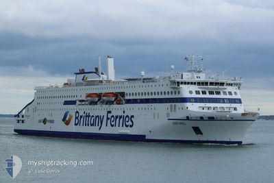
SAINT-MALO
Passenger
Current Trip
| Trip Time | 10 h, 33 mins |
|---|---|
| Trip Distance | 164.18 nm |
| AVG Speed | 15.2 Knots |
| MAX Speed | 21.7 Knots |
| Draught | 6 m |
| AVG Wind | 23.9 knots |
| MAX Wind | 30 knots |
| MIN Temp | 12.2°C / 53.96°F |
| MAX Temp | 13.6°C / 56.48°F |
| Position Received | 1 m ago |
Current Position
| Longitude | --- |
|---|---|
| Latitude | --- |
| Status | Under way using engine |
| Speed | 1.5 Knots |
| Course | 147° |
| Area | English Channel |
| Station | T-AIS |
| Position Received | 1 m ago |
Info
Information
The current position of SAINT-MALO is in English Channel with coordinates 48.64046° / -2.03211° as reported on 2025-12-09 07:06 by AIS to our vessel tracker app. The vessel's current speed is 1.5 Knots and is currently inside the port of SAINT MALO.
The vessel SAINT-MALO (IMO: 9946336, MMSI: 228457700) is a Passenger It's sailing under the flag of [FR] France.
In this page you can find informations about the vessels current position, last detected port calls, and current voyage information. If the vessels is not in coverage by AIS you will find the latest position.
The current position of SAINT-MALO is detected by our AIS receivers and we are not responsible for the reliability of the data. The last position was recorded while the vessel was in Coverage by the Ais receivers of our vessel tracking app.
The current draught of SAINT-MALO as reported by AIS is 6 meters
Weather
| Temperature | 13.1°C / 55.58°F |
|---|---|
| Wind Speed | 23 knots |
| Direction | 180° S |
| Pressure | 1005.6 hPa |
| Humidity | 79.7 % |
| Cloud Coverage | 90 % |
Featured Company
Last Port Calls
| Port | Arrival | Departure | Time In Port |
|---|---|---|---|
| 2025-12-09 08:05 | |||
| 2025-12-08 18:20 | 2025-12-08 20:32 | 2 h | |
| 2025-12-08 08:04 | 2025-12-08 10:36 | 2 h | |
| 2025-12-07 18:14 | 2025-12-07 20:18 | 2 h | |
| 2025-12-07 08:49 | 2025-12-07 11:43 | 2 h | |
| 2025-12-06 07:52 | 2025-12-06 20:26 | 12 h | |
| 2025-12-05 07:29 | 2025-12-05 20:41 | 13 h | |
| 2025-12-04 07:59 | 2025-12-04 20:41 | 12 h | |
| 2025-12-03 07:26 | 2025-12-03 20:22 | 12 h | |
| 2025-12-02 18:12 | 2025-12-02 20:39 | 2 h |
Most Visited Ports (Last year)
| Port | Arrivals | |
|---|---|---|
| 243 | ||
| 242 | ||
| 8 | ||
| 8 | ||
| 7 | ||
| 2 |
Last Trips
| Origin | Departure | Destination | Arrival | Distance | |
|---|---|---|---|---|---|
| 2025-12-08 20:32 | 2025-12-09 08:05 | 164.18 nm | |||
| 2025-12-08 10:36 | 2025-12-08 18:20 | 152.04 nm | |||
| 2025-12-07 20:18 | 2025-12-08 08:04 | 154.23 nm | |||
| 2025-12-07 11:43 | 2025-12-07 18:14 | 70.57 nm | |||
| 2025-12-06 20:26 | 2025-12-07 08:49 | 160.19 nm | |||
| 2025-12-05 20:41 | 2025-12-06 07:52 | 158.40 nm | |||
| 2025-12-04 20:41 | 2025-12-05 07:29 | 156.89 nm | |||
| 2025-12-03 20:22 | 2025-12-04 07:59 | 158.67 nm | |||
| 2025-12-02 20:39 | 2025-12-03 07:26 | 151.82 nm | |||
| 2025-12-02 13:21 | 2025-12-02 18:12 | 91.92 nm |
Events
| Time | Event | Details | Position / Dest | Info |
|---|---|---|---|---|
| 2025-12-09 07:05 | PORT ARRIVAL |
|
48.64051 / -2.03218
[FR] SAINT MALO
|
Speed: 1.8 kn Course: 144° |
| 2025-12-09 06:17 | Change Sea Area | French part of the English Channel Jersey part of the English Channel |
48.77602 / -2.17409
English Channel
FR SML
|
Speed: 20.2 kn Course: 144.1° |
| 2025-12-09 04:42 | Change Sea Area | Jersey part of the English Channel Guernsey part of the English Channel |
49.25616 / -2.49385
English Channel
FR SML
|
Speed: 20 kn Course: 163.6° |
| 2025-12-09 04:34 | Status Changed | Under way using engine Default |
49.30260 / -2.51409
FR SML
|
Speed: 20.7 kn Course: 165° |
| 2025-12-09 04:31 | Status Changed | Default Under way using engine |
49.31789 / -2.52068
FR SML
|
Speed: 20.4 kn Course: 164.1° |
| 2025-12-09 03:01 | Status Changed | Under way using engine Default |
49.62380 / -2.14176
FR SML
|
Speed: 17.9 kn Course: 204° |
| 2025-12-09 02:59 | Status Changed | Default Under way using engine |
49.63322 / -2.13510
FR SML
|
Speed: 18.7 kn Course: 203.1° |
| 2025-12-09 02:48 | Change Sea Area | Guernsey part of the English Channel United Kingdom part of the English Channel |
49.68341 / -2.10061
English Channel
FR SML
|
Speed: 19.1 kn Course: 203.2° |
| 2025-12-09 02:48 | Status Changed | Under way using engine Default |
49.68341 / -2.10061
FR SML
|
Speed: 19.2 kn Course: 203° |
| 2025-12-09 02:35 | IN Coverage |
49.68341 / -2.10061
English Channel
FR SML
|
Speed: 19.1 kn Course: 203.2° |