
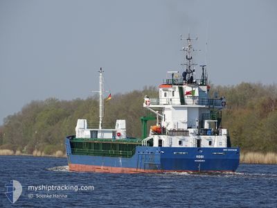
ROSI
General Cargo
Current Trip
| Time Travelled | 5 days |
|---|---|
| Remaining Time | --- |
| Distance Travelled | 1202.02 nm |
| Remaining Distance | --- |
| AVG Speed | 10.1 Knots |
| MAX Speed | 17 Knots |
| AVG Wind | 13.7 knots |
| MAX Wind | 28.4 knots |
| MIN Temp | 0.5°C / 32.9°F |
| MAX Temp | 8.4°C / 47.12°F |
| Draught | 5.3 m |
| Position Received | Now |
Current Position
| Longitude | -6.49836° |
|---|---|
| Latitude | 55.47627° |
| Status | Under way using engine |
| Speed | 12.3 Knots |
| Course | 128.2° |
| Area | Inner Seas off the West Coast of Scotland |
| Station | T-AIS |
| Position Received | Now |
Info
Information
The current position of ROSI is in Inner Seas off the West Coast of Scotland with coordinates 55.47627° / -6.49836° as reported on 2024-04-25 19:58 by AIS to our vessel tracker app. The vessel's current speed is 12.3 Knots and is heading at the port of AYR. The estimated time of arrival as calculated by MyShipTracking vessel tracking app is 2024-04-26 05:00 LT
The vessel ROSI (IMO: 9517238, MMSI: 255805952) is a General Cargo that was built in 2010 ( 14 years old ). It's sailing under the flag of [PT] Portugal.
In this page you can find informations about the vessels current position, last detected port calls, and current voyage information. If the vessels is not in coverage by AIS you will find the latest position.
The current position of ROSI is detected by our AIS receivers and we are not responsible for the reliability of the data. The last position was recorded while the vessel was in Coverage by the Ais receivers of our vessel tracking app.
The current draught of ROSI as reported by AIS is 5.3 meters
Weather
| Temperature | 8.4°C / 47.12°F |
|---|---|
| Wind Speed | 15 knots |
| Direction | 4° N |
| Pressure | 1004.2 hPa |
| Humidity | 68.1 % |
| Cloud Coverage | 13 % |
Featured Company
Last Port Calls
| Port | Arrival | Departure | Time In Port |
|---|---|---|---|
| 2024-04-19 07:10 | 2024-04-20 16:00 | 1 d | |
| 2024-04-18 04:01 | 2024-04-18 05:51 | 1 h | |
| 2024-04-17 01:34 | 2024-04-17 21:41 | 20 h | |
| 2024-04-16 18:28 | 2024-04-16 18:48 | 20 m | |
| 2024-04-13 12:24 | 2024-04-13 12:28 | 4 m | |
| 2024-03-27 05:44 | 2024-03-29 21:13 | 2 d | |
| 2024-02-22 10:32 | 2024-03-21 19:34 | 28 d | |
| 2024-02-14 10:32 | 2024-02-16 14:24 | 2 d |
Most Visited Ports (Last year)
| Port | Arrivals | |
|---|---|---|
| 3 | ||
| 2 | ||
| 2 | ||
| 2 | ||
| 2 | ||
| 2 |
Last Trips
| Origin | Departure | Destination | Arrival | Distance | |
|---|---|---|---|---|---|
| 2024-04-18 07:51 | 2024-04-19 10:10 | 254.34 nm | |||
| 2024-04-17 23:41 | 2024-04-18 06:01 | 65.61 nm | |||
| 2024-04-16 20:48 | 2024-04-17 03:34 | 65.63 nm | |||
| 2024-04-13 14:28 | 2024-04-16 20:28 | 468.55 nm | |||
| 2024-03-29 22:13 | 2024-04-13 14:24 | 3376.39 nm | |||
| 2024-03-21 22:34 | 2024-03-27 06:44 | 1160.30 nm | |||
| 2024-02-16 16:24 | 2024-02-22 13:32 | 684.31 nm | |||
| 2024-01-30 05:37 | 2024-02-14 12:32 | 3381.91 nm |
Events
| Time | Event | Details | Position / Dest | Info |
|---|---|---|---|---|
| 2024-04-25 17:54 | ETA Changed | 2024/04/26 05:00 2024/04/26 07:00 |
55.76423 / -6.87641
GB AYR
|
Speed: 9.1 kn Course: 159.2° |
| 2024-04-25 17:04 | Change Sea Area | United Kingdom part of the Inner Seas off the West Coast of Scotland United Kingdom part of the North Atlantic Ocean |
55.87850 / -6.96242
Inner Seas off the West Coast of Scotland
GB AYR
|
Speed: 9.1 kn Course: 159.6° |
| 2024-04-25 17:04 | Status Changed | Under way using engine Default |
55.87850 / -6.96242
GB AYR
|
Speed: 9 kn Course: 160° |
| 2024-04-25 16:46 | IN Coverage |
55.87850 / -6.96242
Inner Seas off the West Coast of Scotland
GB AYR
|
Speed: 9.1 kn Course: 159.6° |
|
| 2024-04-24 19:27 | Status Changed | Default Under way using engine |
58.69167 / -4.45167
GB AYR
|
Speed: 8.8 kn Course: 267.2° |
| 2024-04-24 19:26 | Status Changed | Under way using engine Default |
58.69268 / -4.44699
GB AYR
|
Speed: 8 kn Course: 268° |
| 2024-04-24 19:26 | OUT of Coverage |
58.69268 / -4.44699
North Atlantic Ocean
GB AYR
|
Speed: 8.8 kn Course: 267.2° |
|
| 2024-04-24 19:18 | Status Changed | Default Under way using engine |
58.69346 / -4.41332
GB AYR
|
Speed: 8.8 kn Course: 269.7° |
| 2024-04-24 16:08 | Change Sea Area | United Kingdom part of the North Atlantic Ocean United Kingdom part of the North Sea |
58.72819 / -3.42863
North Atlantic Ocean
GB AYR
|
Speed: 12 kn Course: 268° |
| 2024-04-24 14:38 | ETA Changed | 2024/04/26 07:00 2024/04/26 02:00 |
58.71281 / -2.74643
GB AYR
|
Speed: 10.5 kn Course: 274.3° |