
ROCKET
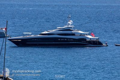
Yacht
Current Trip
MARS AL ARAB MARINA
| Time Travelled | 26 days |
|---|---|
| Remaining Time | --- |
| Distance Travelled | 25.77 nm |
| Remaining Distance | --- |
| AVG Speed | 7.6 Knots |
| MAX Speed | 14.5 Knots |
| AVG Wind | 10.5 knots |
| MAX Wind | 12 knots |
| MIN Temp | 20.4°C / 68.72°F |
| MAX Temp | 28.1°C / 82.58°F |
| Draught | 2.6 m |
| Position Received | 19 h, 33 m ago |
Current Position
| Longitude | --- |
|---|---|
| Latitude | --- |
| Status | Under way sailing |
| Speed | 2.6 Knots |
| Course | 167° |
| Area | Persian Gulf |
| Station | T-AIS |
| Position Received | 19 h, 33 m ago |
Info
Information
The current position of ROCKET is in Persian Gulf with coordinates 25.14854° / 55.19142° as reported on 2024-12-12 17:26 by AIS to our vessel tracker app. The vessel's current speed is 2.6 Knots
The vessel ROCKET (IMO: 9630236, MMSI: 319152100) is a Yacht that was built in 2011 ( 13 years old ). It's sailing under the flag of [KY] Cayman Is.
In this page you can find informations about the vessels current position, last detected port calls, and current voyage information. If the vessels is not in coverage by AIS you will find the latest position.
The current position of ROCKET is detected by our AIS receivers and we are not responsible for the reliability of the data. The last position was recorded while the vessel was in Coverage by the Ais receivers of our vessel tracking app.
The current draught of ROCKET as reported by AIS is 2.6 meters
Weather
| Temperature | 23.8°C / 74.84°F |
|---|---|
| Wind Speed | 10 knots |
| Direction | 23° NNE |
| Pressure | 1017.3 hPa |
| Humidity | 58.1 % |
| Cloud Coverage | --- |
Featured Company
Most Visited Ports (Last year)
| Port | Arrivals | |
|---|---|---|
| 3 | ||
| 3 | ||
| 1 | ||
| 1 | ||
| 1 | ||
| 1 |
Events
| Time | Event | Details | Position / Dest | Info |
|---|---|---|---|---|
| 2024-12-12 17:26 | OUT of Coverage |
25.14854 / 55.19142
Persian Gulf
|
Speed: 2.6 kn Course: 157.4° |
|
| 2024-12-12 16:34 | START Moving | 0.91 nm, North West of DUBAI MARINA |
25.08683 / 55.12532
MARS AL ARAB MARINA
|
Speed: 6.4 kn Course: 299.8° |
| 2024-12-12 16:24 | Status Changed | Under way sailing At anchor |
25.08548 / 55.12609
MARS AL ARAB MARINA
|
Speed: 0.5 kn Course: 358° |
| 2024-12-12 15:40 | Status Changed | At anchor Under way sailing |
25.08544 / 55.12608
MARS AL ARAB MARINA
|
Speed: 0.3 kn Course: 20° |
| 2024-12-12 15:06 | STOP Moving | 0.82 nm, North West of DUBAI MARINA |
25.08511 / 55.12608
MARS AL ARAB MARINA
|
Speed: 0.3 kn Course: 47° |
| 2024-12-12 14:28 | Status Changed | Under way sailing Moored |
25.14485 / 55.12387
MARS AL ARAB MARINA
|
Speed: 8.4 kn Course: 238.8° |
| 2024-12-12 14:17 | ETA Changed | 2025/11/17 17:30 2024/11/17 17:30 |
25.14588 / 55.15008
MARS AL ARAB MARINA
|
Speed: 7.7 kn Course: 321.5° |
| 2024-12-12 13:54 | IN Coverage |
25.15002 / 55.18879
Persian Gulf
|
Speed: 5.1 kn Course: 280.5° |
|
| 2024-12-08 03:35 | OUT of Coverage |
25.14719 / 55.18943
Persian Gulf
|
Speed: Course: 39.2° |
|
| 2024-12-08 03:35 | IN Coverage |
25.14719 / 55.18943
Persian Gulf
|
Speed: Course: 39.2° |