
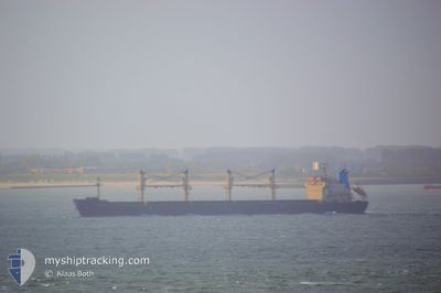
RIZIK BEY
Bulk Carrier
Current Trip
| Time Travelled | 1 day |
|---|---|
| Remaining Time | --- |
| Distance Travelled | 219.52 nm |
| Remaining Distance | --- |
| AVG Speed | 8.4 Knots |
| MAX Speed | 10.6 Knots |
| AVG Wind | 16.4 knots |
| MAX Wind | 25 knots |
| MIN Temp | 1.6°C / 34.88°F |
| MAX Temp | 4.3°C / 39.74°F |
| Draught | 10.9 m |
| Position Received | 1 m ago |
Current Position
| Longitude | 23.11396° |
|---|---|
| Latitude | 59.59292° |
| Status | Under way using engine |
| Speed | 10.3 Knots |
| Course | 253.9° |
| Area | Gulf of Finland |
| Station | T-AIS |
| Position Received | 1 m ago |
Info
Information
The current position of RIZIK BEY is in Gulf of Finland with coordinates 59.59292° / 23.11396° as reported on 2024-04-25 12:29 by AIS to our vessel tracker app. The vessel's current speed is 10.3 Knots and is heading at the port of ABU QIR. The estimated time of arrival as calculated by MyShipTracking vessel tracking app is 2024-05-10 12:00 LT
The vessel RIZIK BEY (IMO: 9285419, MMSI: 620862000) is a Bulk Carrier that was built in 2004 ( 20 years old ). It's sailing under the flag of [KM] Comoros.
In this page you can find informations about the vessels current position, last detected port calls, and current voyage information. If the vessels is not in coverage by AIS you will find the latest position.
The current position of RIZIK BEY is detected by our AIS receivers and we are not responsible for the reliability of the data. The last position was recorded while the vessel was in Coverage by the Ais receivers of our vessel tracking app.
The current draught of RIZIK BEY as reported by AIS is 10.9 meters
Weather
| Temperature | 2.1°C / 35.78°F |
|---|---|
| Wind Speed | 21 knots |
| Direction | 61° ENE |
| Pressure | 1003.8 hPa |
| Humidity | 97.3 % |
| Cloud Coverage | 100 % |
Featured Company
Last Port Calls
| Port | Arrival | Departure | Time In Port |
|---|---|---|---|
| 2024-04-21 04:16 | 2024-04-24 10:28 | 3 d | |
| 2024-02-27 18:07 | 2024-02-29 01:07 | 1 d | |
| 2024-02-05 17:14 | 2024-02-14 11:55 | 8 d |
Most Visited Ports (Last year)
| Port | Arrivals | |
|---|---|---|
| 4 | ||
| 2 | ||
| 2 | ||
| 2 | ||
| 2 | ||
| 1 |
Last Trips
| Origin | Departure | Destination | Arrival | Distance | |
|---|---|---|---|---|---|
| 2024-02-29 04:07 | 2024-04-21 07:16 | 6123.27 nm | |||
| 2024-02-14 14:55 | 2024-02-27 21:07 | 687.89 nm | |||
| 2024-01-18 15:07 | 2024-02-05 20:14 | 3581.20 nm |
Events
| Time | Event | Details | Position / Dest | Info |
|---|---|---|---|---|
| 2024-04-25 10:45 | Status Changed | Under way using engine Default |
59.67627 / 23.67622
EG AKI
|
Speed: 10.3 kn Course: 256° |
| 2024-04-25 10:28 | IN Coverage |
59.67522 / 23.66993
Gulf of Finland
EG AKI
|
Speed: 10.3 kn Course: 251.2° |
|
| 2024-04-25 09:16 | Status Changed | Default Under way using engine |
59.74861 / 24.15981
EG AKI
|
Speed: 10.3 kn Course: 254.7° |
| 2024-04-25 09:11 | OUT of Coverage |
59.75239 / 24.18623
Gulf of Finland
EG AKI
|
Speed: 10.3 kn Course: 254.7° |
|
| 2024-04-25 07:29 | Detected in Sea | Finnish part of the Gulf of Finland |
59.82671 / 24.75659
Gulf of Finland
EG AKI
|
Speed: 10.3 kn Course: 257.6° |
| 2024-04-25 05:35 | Detected in Sea | Estonian part of the Gulf of Finland |
59.88230 / 25.31640
Gulf of Finland
EG AKI
|
Speed: 8.3 kn Course: 263° |
| 2024-04-25 03:58 | Status Changed | Under way using engine Default |
59.91445 / 25.75763
EG AKI
|
Speed: 8.2 kn Course: 257° |
| 2024-04-25 03:56 | Status Changed | Default Under way using engine |
59.91511 / 25.76347
EG AKI
|
Speed: 8.2 kn Course: 258.4° |
| 2024-04-25 02:55 | Detected in Sea | Finnish part of the Gulf of Finland |
59.94963 / 26.03841
Gulf of Finland
EG AKI
|
Speed: 8.3 kn Course: 252.2° |
| 2024-04-25 02:55 | Status Changed | Under way using engine Default |
59.94977 / 26.03929
EG AKI
|
Speed: 8.3 kn Course: 254° |